קובץ:ירוּשׁלם בימי החורבן השניElijah Saphir, מפת ארץ ישראל (פלשתינה) (FL199992287 2369250) (cropped).jpg

גודל התצוגה המקדימה הזאת: 550 × 600 פיקסלים. רזולוציות אחרות: 220 × 240 פיקסלים | 440 × 480 פיקסלים | 704 × 768 פיקסלים | 939 × 1,024 פיקסלים | 1,878 × 2,048 פיקסלים | 4,152 × 4,528 פיקסלים.
לקובץ המקורי (4,152 × 4,528 פיקסלים, גודל הקובץ: 28.33 מ"ב, סוג MIME: image/jpeg)
| זהו קובץ שמקורו במיזם ויקישיתוף. תיאורו בדף תיאור הקובץ המקורי (בעברית) מוצג למטה. |
תקציר
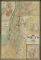
| מַפַּת אֶרֶץ יִשְׂרָאֵל
|
|||||||||||||||||||||||||||||||||||||||||||||||||||||||||
|---|---|---|---|---|---|---|---|---|---|---|---|---|---|---|---|---|---|---|---|---|---|---|---|---|---|---|---|---|---|---|---|---|---|---|---|---|---|---|---|---|---|---|---|---|---|---|---|---|---|---|---|---|---|---|---|---|---|
| אומן |
|
_(FL199992287_2369250).jpg) | |||||||||||||||||||||||||||||||||||||||||||||||||||||||
| כותרת |
ירוּשׁלם בימי החורבן השני |
||||||||||||||||||||||||||||||||||||||||||||||||||||||||
| מפרסם | |||||||||||||||||||||||||||||||||||||||||||||||||||||||||
| סוג אובייקט |
מפה טופוגרפית |
||||||||||||||||||||||||||||||||||||||||||||||||||||||||
| סוגה |
מפה |
||||||||||||||||||||||||||||||||||||||||||||||||||||||||
| תיאור |
מפת ארץ ישראל (פלשתינה). עפי מפת קיפרט ערוכה עי א. ספיר והמהנדס א. קרוזה.. |
||||||||||||||||||||||||||||||||||||||||||||||||||||||||
| שפה |
עברית |
||||||||||||||||||||||||||||||||||||||||||||||||||||||||
| תאריך הוצאה לאור |
בין 1912 ו- 1913 |
||||||||||||||||||||||||||||||||||||||||||||||||||||||||
| ממדים |
גובה: 1,920 מ"מ |
||||||||||||||||||||||||||||||||||||||||||||||||||||||||
| אוסף |
|
||||||||||||||||||||||||||||||||||||||||||||||||||||||||
| מיקום נוכחי |
|
||||||||||||||||||||||||||||||||||||||||||||||||||||||||
| מיקום הוצאה |
ברלין |
||||||||||||||||||||||||||||||||||||||||||||||||||||||||
| הערות |
Gezeichnet v. Paul Krause & Sandor Kästner; Lithographie & Druck v. Dietrich Reimer (E.Vohsen) | ||||||||||||||||||||||||||||||||||||||||||||||||||||||||
| קנה מידה | 1:6,000 m. | ||||||||||||||||||||||||||||||||||||||||||||||||||||||||
| IE PID | IE199992285 | ||||||||||||||||||||||||||||||||||||||||||||||||||||||||
| רוזטה שם קובץ | FL199992287 | ||||||||||||||||||||||||||||||||||||||||||||||||||||||||
| מזהה רשומה בספרייה הלאומית (P3959) | 990023692500205171 | ||||||||||||||||||||||||||||||||||||||||||||||||||||||||
| חיפוש בקטלוג מרחב | עברית, אליהו ספיר, ברלין | ||||||||||||||||||||||||||||||||||||||||||||||||||||||||
| חיפוש בקטלוג מרחב | Twelve tribes of IsraelMapsהוצאת הועד הפועל הציוני (ברלין) | ||||||||||||||||||||||||||||||||||||||||||||||||||||||||
| מקור/צלם |
|
||||||||||||||||||||||||||||||||||||||||||||||||||||||||
| גרסאות אחרות | |||||||||||||||||||||||||||||||||||||||||||||||||||||||||
| Jpg / Tif version |
|
||||||||||||||||||||||||||||||||||||||||||||||||||||||||

Loescher_%26_btv1b8453164n_(cropped).jpg)


_(FL199992287_2369250)_(cropped).jpg)
_(FL199992287_2369250)_(cropped).jpg?uselang=he)
רישיון
The copyright situation of this work is theoretically uncertain, because in the country of origin copyright lasts 70 years after the death of the author, and the date of the author's death is unknown. However, the date of creation of the work was over 120 years ago, and it is thus a reasonable assumption that the copyright has expired (see here for the community discussion). Do not use this template if the date of death of the author is known.
| |
| הקובץ הזה זוהה כקובץ חופשי מכל מגבלה ידועה תחת חוק זכויות היוצרים, כולל כל הזכויות הקשורות והסמוכות. | |
היסטוריית הקובץ
ניתן ללחוץ על תאריך/שעה כדי לראות את הקובץ כפי שנראה באותו זמן.
| תאריך/שעה | תמונה ממוזערת | ממדים | משתמש | הערה | |
|---|---|---|---|---|---|
| נוכחית | 01:24, 28 ביולי 2023 | | 4,528 × 4,152 (28.33 מ"ב) | Geagea | File:Elijah Saphir, מפת ארץ ישראל (פלשתינה) (FL199992287 2369250).jpg cropped 69 % horizontally, 77 % vertically using CropTool with precise mode. |
_(FL199992287_2369250).jpg)
שימוש בקובץ
הדף הבא משתמש בקובץ הזה:
_(FL199992287_2369250)_(cropped).jpg)