קובץ:C74112s5 Ant.Map Martin Peninsula.jpg

גודל התצוגה המקדימה הזאת: 581 × 599 פיקסלים. רזולוציות אחרות: 233 × 240 פיקסלים | 465 × 480 פיקסלים | 745 × 768 פיקסלים | 993 × 1,024 פיקסלים | 1,985 × 2,048 פיקסלים | 3,621 × 3,735 פיקסלים.
לקובץ המקורי (3,621 × 3,735 פיקסלים, גודל הקובץ: 1.52 מ"ב, סוג MIME: image/jpeg)
| זהו קובץ שמקורו במיזם ויקישיתוף. תיאורו בדף תיאור הקובץ המקורי (בעברית) מוצג למטה. |
תקציר
| תיאור |
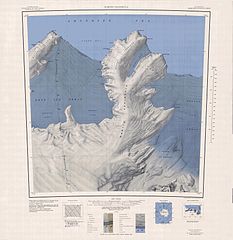
English: 1:250,000-scale topographic reconnaissance map of the Martin Peninsula area from 112°30'-117°W to 73°45'-75°S in Antarctica, including the eastern parts of the Getz Ice Shelf and the western parts of Dotson Ice Shelf. Mapped, edited and published by the U.S. Geological Survey in cooperation with the National Science Foundation. |
|||
| תאריך יצירה | ||||
| מקור | http://usarc.usgs.gov/drg_dload.shtml | |||
| יוצר | United States Geological Survey | |||
| אישורים והיתרים (שימוש חוזר בקובץ זה) |
|
היסטוריית הקובץ
ניתן ללחוץ על תאריך/שעה כדי לראות את הקובץ כפי שנראה באותו זמן.
| תאריך/שעה | תמונה ממוזערת | ממדים | משתמש | הערה | |
|---|---|---|---|---|---|
| נוכחית | 09:31, 4 באפריל 2005 | | 3,735 × 3,621 (1.52 מ"ב) | Achim Raschka | Map of Antarctica by the United States Antarctic Ressource Center of the US Geological Society. {{PD-US}} Copyrights and Trademarks USGS-authored or produced data and information are in the public domain. While the content of most USGS web pages is in th |
שימוש בקובץ
הדף הבא משתמש בקובץ הזה:
שימוש גלובלי בקובץ
אתרי הוויקי השונים הבאים משתמשים בקובץ זה:
- שימוש באתר ceb.wikipedia.org
- שימוש באתר de.wikipedia.org
- Martin-Halbinsel
- Kap Felt
- Kap Herlacher
- Binder Rocks
- Siglin Rocks
- Schneider Rock
- Klimov Bluff
- Jenkins Heights
- McClinton-Gletscher
- Spaulding-Halbinsel
- Coyer Point
- Jacobsen Head
- Slichter Foreland
- Dorchuck-Gletscher
- Klinger Ridge
- Ellis Ridge
- Keys-Gletscher
- Furman Bluffs
- Philbin Inlet
- Murray Foreland
- Hadley Point
- Maumee-Piedmont-Gletscher
- Rydelek-Eisfälle
- Smythe Shoulder
- Singer-Gletscher
- Tucker Point
- Nowicki Foreland
- שימוש באתר en.wikipedia.org
- שימוש באתר fr.wikipedia.org
- שימוש באתר hi.wikipedia.org
- שימוש באתר it.wikipedia.org