קובץ:C78192s1 Ant.Map Mount Discovery.jpg

גודל התצוגה המקדימה הזאת: 602 × 600 פיקסלים. רזולוציות אחרות: 241 × 240 פיקסלים | 482 × 480 פיקסלים | 771 × 768 פיקסלים | 1,028 × 1,024 פיקסלים | 2,055 × 2,048 פיקסלים | 3,080 × 3,069 פיקסלים.
לקובץ המקורי (3,080 × 3,069 פיקסלים, גודל הקובץ: 2.34 מ"ב, סוג MIME: image/jpeg)
| זהו קובץ שמקורו במיזם ויקישיתוף. תיאורו בדף תיאור הקובץ המקורי (בעברית) מוצג למטה. |
| תיאור |
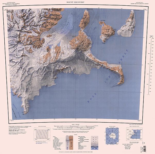
English: Map of Antarctica by the United States Antarctic Resource Center of the US Geological Society. |
| מקור | USGS |
| יוצר | USGS |
This image is in the public domain in the United States because it only contains materials that originally came from the United States Geological Survey, an agency of the United States Department of the Interior. For more information, see the official USGS copyright policy.
|
היסטוריית הקובץ
ניתן ללחוץ על תאריך/שעה כדי לראות את הקובץ כפי שנראה באותו זמן.
| תאריך/שעה | תמונה ממוזערת | ממדים | משתמש | הערה | |
|---|---|---|---|---|---|
| נוכחית | 21:12, 23 בנובמבר 2015 | | 3,069 × 3,080 (2.34 מ"ב) | ValeriySh | Обрізка зайвого поля |
| 12:51, 4 באפריל 2005 |  | 3,253 × 4,358 (1.44 מ"ב) | Achim Raschka | Map of Antarctica by the United States Antarctic Ressource Center of the US Geological Society. {{PD-US}} Copyrights and Trademarks USGS-authored or produced data and information are in the public domain. While the content of most USGS web pages is in th |
שימוש בקובץ
הדף הבא משתמש בקובץ הזה:
שימוש גלובלי בקובץ
אתרי הוויקי השונים הבאים משתמשים בקובץ זה:
- שימוש באתר bg.wikipedia.org
- שימוש באתר ceb.wikipedia.org
- שימוש באתר de.wikipedia.org
- Antarktische Trockentäler
- Royal Society Range
- Minna Bluff
- White Island (Ross-Archipel)
- Black Island (Ross-Archipel)
- Mount Rucker
- Koettlitz-Gletscher
- Skelton-Gletscher
- Rutgers-Gletscher
- Johns Hopkins Ridge
- Mount Henderson (White Island)
- Isolation Point
- Marshall Valley
- Denton Hills
- Heald-Insel
- Ward Lake
- The Bulwark
- Shults-Halbinsel
- Brown-Halbinsel
- Mount Aurora
- Kap Beck
- Hahn Island
- Bishop Peak
- Diskussion:Borg Bastion
- Bowden-Gletscher
- Salient Ridge
- Bratina Island
- Bratina-Lagune
- Mount Nesos
- Lake Cole
- Mount Melania
- Mount Vision
- Dreary Isthmus
- Eastface-Nunatak
- Rainbow Ridge
- Scallop Hill
- Cape Spirit
- Mount Hayward
- Mount Heine
- Kap Hodgson
- Rucker Ridge
- Minna Hook
- Minna Saddle
- Moraine Bluff