קובץ:Czechoslovakia I.png
גודל התצוגה המקדימה הזאת: 800 × 364 פיקסלים. רזולוציות אחרות: 320 × 146 פיקסלים | 640 × 291 פיקסלים | 1,128 × 513 פיקסלים.
לקובץ המקורי (1,128 × 513 פיקסלים, גודל הקובץ: 66 ק"ב, סוג MIME: image/png)
| זהו קובץ שמקורו במיזם ויקישיתוף. תיאורו בדף תיאור הקובץ המקורי (בעברית) מוצג למטה. |
| תיאור |
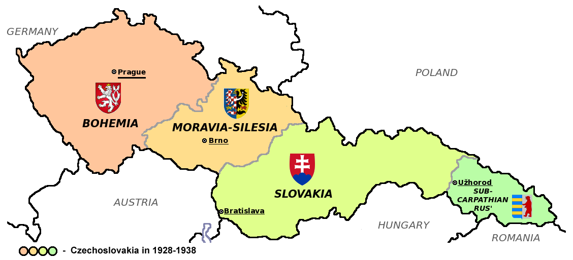
Čeština: Zemská mapa Československa v letech 1928 až 1938 s vyznačenými zemskými hlavními městy a znaky jednotlivých zemí English: Maps of Czechoslovakia in 1928-1938 with marked borders of all four Czechoslovak countries and their coats of arms and regional capital cities
Based on Image:Czechoslovakia_COA_medium.svg. * |
| תאריך יצירה | (UTC) |
| מקור | |
| יוצר | |
| גרסאות אחרות |
Derivative works of this file: |
| זוהי תמונה מרוטשת, זאת אומרת שהתמונה שונתה בצורה דיגיטלית מהמקור. Modifications: Simplified map. את התמונה המקורית ניתן לראות ב: CarpathianRutheniaCoA.svg. השינוי בוצע על ידי Millenium187.
|
הקובץ הזה מתפרסם לפי תנאי רישיון קריאייטיב קומונז ייחוס-שיתוף זהה 3.0 לא מותאם.
- הנכם רשאים:
- לשתף – להעתיק, להפיץ ולהעביר את העבודה
- לערבב בין עבודות – להתאים את העבודה
- תחת התנאים הבאים:
- ייחוס – יש לתת ייחוס הולם, לתת קישור לרישיון, ולציין אם נעשו שינויים. אפשר לעשות את זה בכל צורה סבירה, אבל לא בשום צורה שמשתמע ממנה שמעניק הרישיון תומך בך או בשימוש שלך.
- שיתוף זהה – אם תיצרו רמיקס, תשנו, או תבנו על החומר, חובה עליכם להפיץ את התרומות שלך לפי תנאי רישיון זהה או תואם למקור.
יומן העלאה מקורי
This image is a derivative work of the following images:
- File:Czechoslovakia01.png licensed with PD-self
- 2011-05-19T10:54:48Z PANONIAN 1128x513 (64020 Bytes) minor change, marked provincial capitals
- 2011-05-17T09:53:27Z PANONIAN 1128x513 (63994 Bytes) Reverted to version as of 10:38, 24 April 2011 - because this is map of Czechoslovakia and it was capital of Czechoslovakia
- 2011-05-17T05:07:38Z Millenium187 1128x513 (56086 Bytes) Why was Prague underlined and Vienna, Brno, Bratislava and other capital cities were not? -- corrected
- 2011-04-24T10:38:30Z PANONIAN 1128x513 (63994 Bytes) few corrections
- 2011-04-23T11:31:49Z PANONIAN 1128x509 (62348 Bytes) improved version
- 2008-12-20T20:58:14Z Kirk 1100x497 (80038 Bytes) {{Information |Description= |Source= |Date= |Author= |Permission= |other_versions= }}
- 2006-12-28T16:11:35Z Electionworld 1100x497 (92110 Bytes) {{ew|en|PANONIAN}} Map of {{link|Czechoslovakia}} (self made) Note: The provinces shown on the map were introduced by Act No. 125/1927 Zb. and became effective in 1928. {{PD-self}} [[Category:Maps of Czechoslovakia]] [[Cat
- File:Small_coat_of_arms_of_the_Czech_Republic2.png licensed with PD-self
- 2006-07-18T15:34:18Z Poznaniak 486x594 (126651 Bytes) {{Information |Description=Godło Czech |Source=własna praca |Date=18.07.2006 |Author=[[:user:Poznaniak|Poznaniak]] |Permission= }}
- File:Moravia-Silesia.png licensed with PD-self
- 2010-07-25T21:44:29Z RgC 490x600 (65918 Bytes) {{Information |Description={{en|1=Joint of coat of arms of Moravia and Silesia.}} |Source={{own}} |Author=[[User:RgC|RgC]] |Date=2010-07-25 |Permission= |other_versions= }} [[Category:User page images]]
- File:Coat_of_arms_of_Slovakia.svg licensed with Cc-by-sa-3.0-migrated, GFDL
- 2006-06-06T21:41:47Z Tlusťa 400x500 (4623 Bytes) ==Summary== {{Information |Description={{en|Coat of arms of the [[Slovakia]].}} {{cs|Znak [[:cs:Slovensko|Slovenska]].}} |Source= |Date= |Author=[[User:Tlusťa|Tlusťa]] |Permission= |other_versions= }} ==Licensing == {{GFDL
- File:CarpathianRutheniaCoA.svg licensed with Cc-pd-mark-footer, PD-old
- 2007-06-01T16:53:20Z DDima 325x394 (27235 Bytes) fix colors
- 2006-11-08T06:35:05Z Happenstance 325x394 (27214 Bytes) created
Uploaded with derivativeFX
| Annotations | This image is annotated: View the annotations at Commons |
היסטוריית הקובץ
ניתן ללחוץ על תאריך/שעה כדי לראות את הקובץ כפי שנראה באותו זמן.
| תאריך/שעה | תמונה ממוזערת | ממדים | משתמש | הערה | |
|---|---|---|---|---|---|
| נוכחית | 21:40, 12 באוגוסט 2011 | | 513 × 1,128 (66 ק"ב) | Millenium187 | {{Information |Description={{cs|Zemská mapa Československa v letech 1928 až 1938 s vyznačenými zemskými hlavními městy a znaky jednotlivých zemí}} {{en|Maps of Czechoslovakia in 1928-1938 with marked borders of all four Czechoslovak countries a |
שימוש בקובץ
הדף הבא משתמש בקובץ הזה:
שימוש גלובלי בקובץ
אתרי הוויקי השונים הבאים משתמשים בקובץ זה:
- שימוש באתר azb.wikipedia.org
- שימוש באתר az.wikipedia.org
- שימוש באתר bn.wikipedia.org
- שימוש באתר da.wikipedia.org
- שימוש באתר de.wikipedia.org
- שימוש באתר el.wikipedia.org
- שימוש באתר en.wikipedia.org
- שימוש באתר es.wikipedia.org
- שימוש באתר io.wikipedia.org
- שימוש באתר mk.wikipedia.org
- שימוש באתר sq.wikipedia.org
- שימוש באתר te.wikipedia.org
- שימוש באתר th.wikipedia.org
- שימוש באתר tr.wikipedia.org
- שימוש באתר uk.wikipedia.org