קובץ:Halley compass variations 1702.jpg
גודל התצוגה המקדימה הזאת: 481 × 599 פיקסלים. רזולוציות אחרות: 193 × 240 פיקסלים | 385 × 480 פיקסלים | 642 × 800 פיקסלים.
לקובץ המקורי (642 × 800 פיקסלים, גודל הקובץ: 150 ק"ב, סוג MIME: image/jpeg)
| זהו קובץ שמקורו במיזם ויקישיתוף. תיאורו בדף תיאור הקובץ המקורי (בעברית) מוצג למטה. |
תקציר
| תיאור |
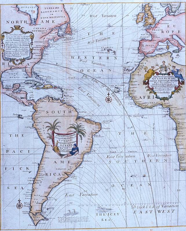
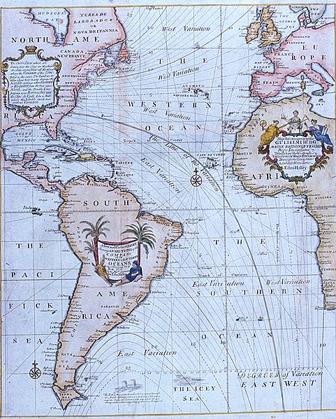
Edmond Halley's New and Correct Chart Shewing the Variations of the Compass (1701), the first chart to show lines of equal magnetic variation. See also exhibit G201:1/1 at the UK National Maritime Museum. The NMM scan may however be protected by copyright in the UK. |
| תאריך יצירה | |
| מקור |
Plate 22 from Mount & Page's 1702 "Atlas Maritimus Novus, or the New Sea-Atlas." This image was found at [1], in the online map database of the Louisiana State Museum, accession number 1982.077.020 |
| יוצר | Edmond Halley |
| גרסאות אחרות | Halley compass variations 1720.jpg |
![[1]](http://lsm.crt.state.la.us/lsmmaps/jpegs/1982.077.020.jpg)
רישיון
|
יצירה זו נמצאת בנחלת הכלל במדינת המקור ובמדינות אחרות בהם תקופת זכויות היוצרים היא משך חיי היוצר ו-100 שנה (או פחות) מפטירתו.
| |
| הקובץ הזה זוהה כקובץ חופשי מכל מגבלה ידועה תחת חוק זכויות היוצרים, כולל כל הזכויות הקשורות והסמוכות. | |
היסטוריית הקובץ
ניתן ללחוץ על תאריך/שעה כדי לראות את הקובץ כפי שנראה באותו זמן.
| תאריך/שעה | תמונה ממוזערת | ממדים | משתמש | הערה | |
|---|---|---|---|---|---|
| נוכחית | 16:44, 2 במאי 2008 | | 800 × 642 (150 ק"ב) | Jheald | {{Information |Description=Edmond Halley's ''New and Correct Chart Shewing the Variations of the Compass'' (1701), the first chart to show lines of equal magnetic variation. <p>See also exhibit [http://www.n |
שימוש בקובץ
הדף הבא משתמש בקובץ הזה:
שימוש גלובלי בקובץ
אתרי הוויקי השונים הבאים משתמשים בקובץ זה:
- שימוש באתר bn.wikipedia.org
- שימוש באתר ca.wikipedia.org
- שימוש באתר en.wikipedia.org
- שימוש באתר eo.wikipedia.org
- שימוש באתר es.wikipedia.org
- שימוש באתר fi.wikipedia.org
- שימוש באתר fr.wikipedia.org
- שימוש באתר it.wikipedia.org
- שימוש באתר nds.wikipedia.org
- שימוש באתר nn.wikipedia.org
- שימוש באתר no.wikipedia.org
- שימוש באתר pt.wikipedia.org
- שימוש באתר ru.wikipedia.org
- שימוש באתר sl.wikipedia.org
- שימוש באתר sv.wikipedia.org
- שימוש באתר th.wikipedia.org
- שימוש באתר uk.wikipedia.org
- שימוש באתר vi.wikipedia.org