לקובץ המקורי(3,600 × 2,800 פיקסלים, גודל הקובץ: 1.16 מ"ב, סוג MIME‏: image/jpeg)

ויקישיתוף זהו קובץ שמקורו במיזם ויקישיתוף. תיאורו בדף תיאור הקובץ המקורי (בעברית) מוצג למטה.

תקציר

תיאור
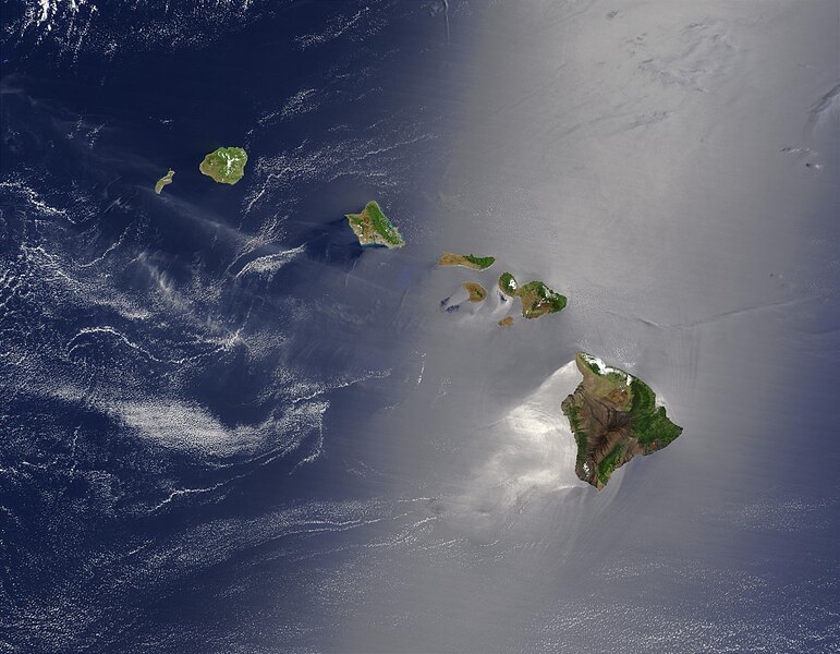
English: Satellite view of Hawaii archipellago (USA).

Original description from NASA:

"A silver swath of sunglint surrounds half of the Hawaiian islands in this true-color Terra MODIS image acquired on May 27, 2003. Sunglint reveals turbulence in the surface waters of the Pacific Ocean. If the surface of the water was as smooth as a perfect mirror, we would see the circle of the Sun as a perfect reflection. But because the surface of the water is ruffled with waves, each wave acts like a mirror and the Sun’s reflection gets softened into a broader silver swath, called the sunglint region.

"In this scene, the winds ruffling the water surface around the Hawaiian Islands create varying patterns, leaving some areas calmer than others. Southwest of Hawaii and Maui, on their leeward sides, calmer waters are indicated by brighter silver coloration. Conversely, notice how most of the vegetation on the Hawaiian Islands grows on their northeastern, or windward, sides.

"From lower right to upper left, the “Big Island” (Hawaii), Maui, Kahoolawe, Lanai, Molokai, Oahu, Kauai, and Niihau islands all make up the state of Hawaii, which lies more than 2,000 miles from any other part of the United States. The small red dot on the Big Island’s southeastern side marks a hot spot on Kilauea Volcano’s southern flank. Kilauea has been erupting almost continuously since January 1983, and is one of the world’s best studied volcanoes."
Français : Vue satellite de l'archipel d'Hawaï (États-Unis).
תאריך יצירה
מקור NASA. Image courtesy Jacques Descloitres, MODIS Land Rapid Response Team at NASA GSFC. (IotD Date: 2003-06-03. IotD ID: 15304)
יוצר Jacques Descloitres
גרסאות אחרות
Modified version
זוהי תמונה מרוטשת, זאת אומרת שהתמונה שונתה בצורה דיגיטלית מהמקור. Modifications: cloned out and healed little red line on the big island. את התמונה המקורית ניתן לראות ב: Hawaje.jpg. השינוי בוצע על ידי IdLoveOne.

Derivative works

Derivative works of this file:  Hawaje-NoRedLine.jpg

רישיון

Public domain קובץ זה נמצא ברשות הציבור מכיוון שהוא נוצר על ידי נאס"א. מדיניות זכויות היוצרים של נאס"א קובעת ש"חומרים של NASA אינם מוגנים בזכויות יוצרים אלא אם צוין אחרת". (דף מדיניות זכויות היוצרים ב-NASA או מדיניות שימוש בתמונות ב-JPL).
אזהרות:
  • שימוש בלוגואים, סמלים וטלאים של נאס"א כפוף להגבלה של החוק בארצות הברית 14 CFR 1221.
  • אתר האינטרנט של נאס"א מכיל תמונות רבות שמקורן מתוכנית החלל הסובייטית/סוכנות החלל הרוסית, וחומרים נוספים של סוכנויות חלל אחרות. קבצים אלו אינם בהכרח תחת רשות הציבור.
  • חומרים מטלסקופ החלל האבל עשויים להיות מוגנים בזכויות יוצרים אם לא מצוין במפורש שהגיעו מSTScI. [1]
  • כל החומרים שנוצרו על ידי חללית SOHO מוגנים בזכויות יוצרים ודורשים הרשאה עבור שימוש מסחרי לא חינוכי. [2]
  • תמונות המוצגות באתר Astronomy Picture of the Day (APOD) עשויים להיות מוגנים בזכויות יוצרים. [3]

כיתובים

נא להוסיף משפט שמסביר מה הקובץ מייצג

פריטים שמוצגים בקובץ הזה

מוצג

היסטוריית הקובץ

ניתן ללחוץ על תאריך/שעה כדי לראות את הקובץ כפי שנראה באותו זמן.

תאריך/שעהתמונה ממוזערתממדיםמשתמשהערה
נוכחית21:19, 26 באוקטובר 2005תמונה ממוזערת לגרסה מ־21:19, 26 באוקטובר 2005‪2,800 × 3,600‬ (1.16 מ"ב)PalladinusHawaii Islands

אין בוויקיפדיה דפים המשתמשים בקובץ זה.

שימוש גלובלי בקובץ

אתרי הוויקי השונים הבאים משתמשים בקובץ זה:

מטא־נתונים