קובץ:Kunyu Wanguo Quantu (坤輿萬國全圖).jpg

גודל התצוגה המקדימה הזאת: 800 × 359 פיקסלים. רזולוציות אחרות: 320 × 144 פיקסלים | 640 × 287 פיקסלים | 1,024 × 460 פיקסלים | 1,280 × 575 פיקסלים | 2,560 × 1,150 פיקסלים | 11,726 × 5,266 פיקסלים.
לקובץ המקורי (11,726 × 5,266 פיקסלים, גודל הקובץ: 16.75 מ"ב, סוג MIME: image/jpeg)
| זהו קובץ שמקורו במיזם ויקישיתוף. תיאורו בדף תיאור הקובץ המקורי (בעברית) מוצג למטה. |
| Warning | The original file is very high-resolution. It might not load properly or could cause your browser to freeze when opened at full size. |
|---|
|

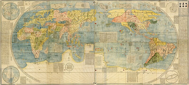
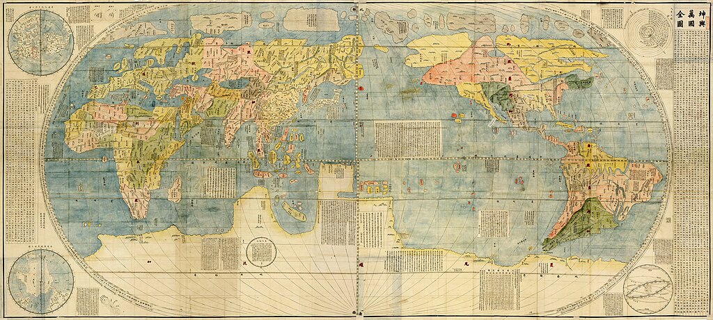
תמונה זו נבחרה כתמונת היום בתאריך 13 ביוני 2010. כותרתה: English: Copy of the 1602 map Kunyu Wanguo Quantu, created by Matteo Ricci at the request of the Wanli Emperor. שפות אחרות:
Čeština: Kchun-jü wan-kuo čchüan-tchu (Mapa nesčetných zemí světa), první čínská mapa světa v evropském stylu, kterou vytvořil jezuitský misionář Matteo Ricci z podnětu císaře Wan-li v roce 1602. Vyobrazený anonymní výtisk, doplněný katakanou psanými poznámkami, byl určen pro japonský trh a pochází z doby kolem roku 1604. Dansk: Kopi af kortet Kunyu Wanguo Quantu fra 1602, fremstillet af Matteo Ricci på ordre fra den kinesiske kejser Wanli. English: Copy of the 1602 map Kunyu Wanguo Quantu, created by Matteo Ricci at the request of the Wanli Emperor. Italiano: Una stampa (1604?) della carta geografica completa di tutti i regni del mondo (pinyin: Kūnyú Wànguó Quántú), il più antico mappamondo cinese sullo stile delle mappe europee. Realizzata, nel 1602, dal gesuita Matteo Ricci su richiesta dell'imperatore Wanli, la mappa contribuì, significativamente, ad ampliare le conoscenze geografiche cinesi sul mondo Magyar: A Kunyu Wanguo Quantu, az első európai stílusú kínai világtérkép, amelyet Matteo Ricci készített 1602-ben a Wanli császár utasítására Nederlands: De Kunyu Wanguo Quantu ("een kaart van de talloze landen van de Wereld") van de jezuïet Matteo Ricci uit 1602, gemaakt in opdracht van de Chinese keizer Wanli. De kaart, die een vertaling was van Europese kaarten, zorgde voor een sterke groei van de Chinese kennis over de wereld. Português: Cópia do mapa de 1602 Kunyu Wanguo Quantu, criado por Matteo Ricci a pedido do Imperador Wanli. Tiếng Việt: Bản sao của tấm Khôn Dư Vạn Quốc Toàn Đồ do Matteo Ricci vẽ năm 1602 theo yêu cầu của Hoàng đế Trung Quốc Minh Thần Tông. Беларуская (тарашкевіца): Мапа Куньюй Ваньго Цюаньту, выдадзеная ўпершыню ў 1602 годзе Матэа Рыччы, італьянскім каталіцкім місыянэрам, па замове імпэратара Ваньлі. Гэта першая вядомая кітайская мапа, створаная ў эўрапейскім стылі Македонски: Примерок на картата на светот „Кунји Вангуо Чиенту“ (1602) од Матео Ричи по барање на кинескиот цар Ванли. Русский: Куньюй Ваньго Цюаньту, впервые данная географическая карта была напечатана в Китае в 1602 году по просьбе императора Ваньли католическим миссионером Маттео Риччи и его китайскими сотрудниками. বাংলা : ১৬০২ সালে চিত্রিত মানচিত্রের একটি কপি। ওয়ানিল সম্রাটের অনুরোধে মাতেও রিসির মানচিত্রটি এঁকেছিলেন। |
תקציר
| תיאור |
Deutsch: Kunyu Wanguo Quantu ist die früheste bekannte chinesische Weltkarte im Stil der europäischen Karten, es wurde zum ersten Mal in China in 1602 von Matteo Ricci.
English: Unattributed, very detailed, two page colored edition (1604?), copy of the 1602 map Kunyu Wanguo Quantu by Matteo Ricci at the request of the Wanli Emperor. This digitalization of the map is of a Japanese export copy of the original Chinese version, with phonetic annotations in Katakana for foreign place names outside of the Sinic world, predominantly around Europe, Russia and the Near East. Note that 金島 [Kinshima, Island of Gold] in its entirety and the label 銀島 [Ginshima, Island of Silver] have been added to Ricci's original.
Español: Kunyu Wanguo Quantu, primer mapamundi chino hecho al estilo europeo y primero en mostrar el continente americano. Hecho originalmente en 1602 por Matteo Ricci.
Français : Kunyu Wanguo Quantu, imprimée en 1602 par Matteo Ricci, est la première carte du monde de style européen connue en chinois.
中文(简体):《坤舆万国全图》。
中文(繁體):《坤輿萬國全圖》。
日本語: 『坤輿万国全図』。 Tiếng Việt: Khôn Dư Vạn Quốc Toàn Đồ. 한국어: 「곤여만국전도」.
Italiano: Un'edizione anonima a colori (1604?) della carta geografica completa di tutti i regni del mondo (pinyin: Kūnyú Wànguó Quántú), il più antico mappamondo cinese sullo stile delle mappe europee, realizzato da Matteo Ricci su richiesta dell'imperatore Wanli.
Türkçe: Konyo Bankoku Zenzu, Japonya'ya ihraç edilen dünya haritası Kunyu Wanguo Quantu 'nun renksiz versiyonuna dayanılarak Kanō ressamları tarafından renkli olarak çizilip basılan katakana ilaveli haritadır. Sağ üst köşesinde Kanō'nun mühürü görülmektedir.
Русский: Куньюй Ваньго Цюаньту самая ранняя известная китайская карта мира в стиле европейских географических карт. |
| תאריך יצירה | המאה ה-17 |
| מקור |
日本語: 東北大学附属図書館狩野文庫画像DB[1] English: Image Database of the Kano Collection, Tohoku University Library[2] File:坤輿萬國全圖(左).jpg,File:坤輿萬國全圖(右).jpg |
| יוצר |
Matteo Ricci |
| Georeferencing | If inappropriate please set warp_status = skip to hide. |
| גרסאות אחרות |
Derivative works of this file:
https://www.lib.umn.edu/bell/riccimap#viewer
|


.jpg)
.jpg?uselang=he)
.jpg)
.jpg)
.jpg)
.Black_Sea.jpg)
.Caspian_Sea.jpg)
.Caucasus.jpg)
_Middle_East.jpg)
רישיון
|
עבודת אמנות דו-מימדית זו המוצגת בתמונה שוחררה לרשות הציבור בכל העולם בעקבות תאריך מותו של היוצר, או תאריך פרסום היצירה. לפיכך, תצלום היצירה גם הוא ברשות הציבור.
הודעה זו תקפה לגבי התצלומים שנוצרו בארצות הברית, בגרמניה ובמדינות רבות נוספות.
| ||||
| Annotations | This image is annotated: View the annotations at Commons |
היסטוריית הקובץ
ניתן ללחוץ על תאריך/שעה כדי לראות את הקובץ כפי שנראה באותו זמן.
| תאריך/שעה | תמונה ממוזערת | ממדים | משתמש | הערה | |
|---|---|---|---|---|---|
| נוכחית | 12:19, 15 בינואר 2010 | | 5,266 × 11,726 (16.75 מ"ב) | PhiLiP | Reverted to version as of 16:13, 13 January 2010 |
| 12:19, 15 בינואר 2010 |  | 5,266 × 11,726 (15.71 מ"ב) | PhiLiP | Reverted to version as of 14:44, 13 January 2010 | |
| 19:13, 13 בינואר 2010 |  | 5,266 × 11,726 (16.75 מ"ב) | PhiLiP | light up | |
| 17:44, 13 בינואר 2010 |  | 5,266 × 11,726 (15.71 מ"ב) | PhiLiP | {{Information |Description={{en|''Impossible Black Tulip''.}} {{zh-hans|《坤舆万国全图》。}} {{zh-hant|《坤輿萬國全圖》。}} |Source= File:坤輿萬國全圖(左).jpg, [[:File:坤輿萬國全圖(� |
שימוש בקובץ
הדפים הבאים משתמשים בקובץ הזה:
שימוש גלובלי בקובץ
אתרי הוויקי השונים הבאים משתמשים בקובץ זה:
- שימוש באתר ar.wikipedia.org
- שימוש באתר ba.wikipedia.org
- שימוש באתר ba.wikibooks.org
- שימוש באתר bn.wikipedia.org
- שימוש באתר ca.wikipedia.org
- שימוש באתר crh.wikipedia.org
- שימוש באתר cs.wikipedia.org
- שימוש באתר cv.wikipedia.org
- שימוש באתר da.wikipedia.org
- שימוש באתר de.wikipedia.org
- שימוש באתר en.wikipedia.org
- World map
- Matthijs Quast
- Early world maps
- Matteo Ricci
- User:Daniel Mietchen/Science communication gallery
- Kunyu Wanguo Quantu
- Talk:Kunyu Wanguo Quantu
- Wikipedia:ITN archives/2010/January
- Wikipedia:Picture peer review/Archives/Apr-Jun 2010
- Wikipedia:Picture peer review/Kunyu Wanguo Quantu
- List of countries by population in 1600
- שימוש באתר es.wikipedia.org
- Usuario:Manuel González Olaechea y Franco/Galería de mapamundi
- Wikipedia:Imágenes destacadas/Diagramas, dibujos y mapas
- Wikipedia:Recurso del día/401 - 500
- Kunyu Wanguo Quantu
- Wikipedia:Candidatos a recursos destacados/坤輿萬國全圖.jpg
- Wikipedia:Candidatos a recursos destacados/Enero-2010
- Plantilla:RDD/448
- Wikiproyecto:Revisores/Revisiones en curso/ArchivoCID
- Wikipedia:Recurso del día/marzo de 2011
- Wikipedia:Recurso del día/octubre de 2012
- Wikipedia:Recurso del día/noviembre de 2014
- Wikipedia:Recurso del día/marzo de 2017
- Wikipedia:Recurso del día/junio de 2019
- Wikipedia:Recurso del día/diciembre de 2021
- שימוש באתר fa.wikipedia.org
- שימוש באתר fr.wikipedia.org
- שימוש באתר ha.wikipedia.org
- שימוש באתר hu.wikipedia.org
- שימוש באתר id.wikipedia.org
.jpg)
.jpg)