קובץ:Map for the Silesian and Seven Years Wars.jpg

גודל התצוגה המקדימה הזאת: 800 × 592 פיקסלים. רזולוציות אחרות: 320 × 237 פיקסלים | 640 × 474 פיקסלים | 1,024 × 758 פיקסלים | 1,280 × 948 פיקסלים | 1,672 × 1,238 פיקסלים.
לקובץ המקורי (1,672 × 1,238 פיקסלים, גודל הקובץ: 438 ק"ב, סוג MIME: image/jpeg)
| זהו קובץ שמקורו במיזם ויקישיתוף. תיאורו בדף תיאור הקובץ המקורי (בעברית) מוצג למטה. |
תקציר
| תיאור |
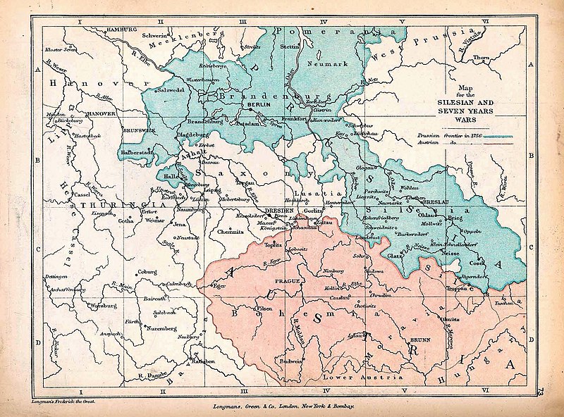
English: A map of Central Europe depicting the principal regions of conflict in the Silesian Wars of the 1740s–60s. The blue and red regions highlight Prussian and Austrian territory (respectively) as of 1756. |
| תאריך יצירה | |
| מקור | The map is taken from "The Public Schools Historical Atlas" by Charles Colbeck. Longmans, Green, & Co.: New York; London; Bombay. 1905. It was accessed through the University of Texas at Austin's Perry-Castañeda Library Map Collection. The original map comes from "Frederick the Great and the Seven Years' War" by Frederick William Longman (1881). |
| יוצר |
Frederick William Longman Charles Colbeck (editor) |
רישיון
|
היוצר נפטר בשנת 1908, לכן יצירה זו נמצאת בנחלת הכלל במדינת המקור ובמדינות אחרות בהם תקופת זכויות היוצרים היא משך חיי היוצר ו-100 שנה (או פחות) מפטירתו.
This work is in the public domain in the United States because it was published (or registered with the U.S. Copyright Office) before January 1, 1929. | |
| הקובץ הזה זוהה כקובץ חופשי מכל מגבלה ידועה תחת חוק זכויות היוצרים, כולל כל הזכויות הקשורות והסמוכות. | |
היסטוריית הקובץ
ניתן ללחוץ על תאריך/שעה כדי לראות את הקובץ כפי שנראה באותו זמן.
| תאריך/שעה | תמונה ממוזערת | ממדים | משתמש | הערה | |
|---|---|---|---|---|---|
| נוכחית | 15:25, 7 באוקטובר 2019 | | 1,238 × 1,672 (438 ק"ב) | Soerfm | Contrast |
| 20:42, 7 בינואר 2019 |  | 1,238 × 1,672 (338 ק"ב) | Bryanrutherford0 | User created page with UploadWizard |
שימוש בקובץ
הדף הבא משתמש בקובץ הזה:
שימוש גלובלי בקובץ
אתרי הוויקי השונים הבאים משתמשים בקובץ זה:
- שימוש באתר cs.wikipedia.org
- שימוש באתר en.wikipedia.org
- Silesian Wars
- Second Silesian War
- Wikipedia:Featured topics
- First Silesian War
- Third Silesian War
- Wikipedia:Featured and good topic candidates/Silesian Wars/archive1
- Wikipedia:Featured and good topic candidates/Featured log/June 2019
- Wikipedia:Featured and good topic candidates/Good log/June 2019
- Wikipedia:Featured topics/Silesian Wars
- Wikipedia:Today's featured article/requests/Silesian Wars
- שימוש באתר es.wikipedia.org
- שימוש באתר fr.wikipedia.org
- שימוש באתר id.wikipedia.org
- שימוש באתר ja.wikipedia.org
- שימוש באתר ka.wikipedia.org
- שימוש באתר pt.wikipedia.org
- שימוש באתר ru.wikipedia.org
- שימוש באתר sr.wikipedia.org
- שימוש באתר vi.wikipedia.org
- שימוש באתר zh.wikipedia.org