קובץ:Redlakeriver-map.png
אין גרסה ברזולוציה גבוהה יותר.
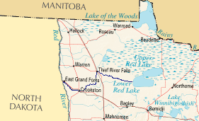
Redlakeriver-map.png (281 × 171 פיקסלים, גודל הקובץ: 15 ק"ב, סוג MIME: image/png)
| זהו קובץ שמקורו במיזם ויקישיתוף. תיאורו בדף תיאור הקובץ המקורי (בעברית) מוצג למטה. |
תקציר
| תיאור | National Atlas image with en:Red Lake River highlighted. |
| תאריך יצירה | 17 במרץ 2006 (תאריך העלאה מקורי) |
| מקור | הועבר מ- en.wikipedia לוויקישיתוף. |
| יוצר |
מעלה היצירה המקורי היה Subsurd מוויקיפדיה האנגלית |
רישיון
This map was obtained from an edition of the National Atlas of the United States. Like almost all works of the U.S. federal government, works from the National Atlas are in the public domain in the United States.
Online access: NationalAtlas.gov | 1970 print edition: Library of Congress, Perry-Castañeda Library
|
יומן העלאה מקורי
תיאור הקובץ המקורי נמצא כאן. כל שמות המשתמשים הבאים מתייחסים ל-en.wikipedia.
- 2006-03-17 19:49 Subsurd 281×171×8 (15238 bytes) [http://www.nationalatlas.gov/printable/images/preview/reference/pagegen_mn.gif National Atlas image] with [[Red Lake River]] highlighted.
היסטוריית הקובץ
ניתן ללחוץ על תאריך/שעה כדי לראות את הקובץ כפי שנראה באותו זמן.
| תאריך/שעה | תמונה ממוזערת | ממדים | משתמש | הערה | |
|---|---|---|---|---|---|
| נוכחית | 23:15, 7 בינואר 2007 | | 171 × 281 (15 ק"ב) | MECU | {{Information |Description=[http://www.nationalatlas.gov/printable/images/preview/reference/pagegen_mn.gif National Atlas image] with en:Red Lake River highlighted. |Source=Originally from [http://en.wikipedia.org en.wikipedia]; description page is/w |
שימוש בקובץ
הדף הבא משתמש בקובץ הזה:
שימוש גלובלי בקובץ
אתרי הוויקי השונים הבאים משתמשים בקובץ זה:
- שימוש באתר de.wikipedia.org
- שימוש באתר en.wikipedia.org
- שימוש באתר www.wikidata.org