קובץ:River valley filled in by pyroclastic flows, Mt. Pinatubo.jpg

River_valley_filled_in_by_pyroclastic_flows,_Mt._Pinatubo.jpg (350 × 454 פיקסלים, גודל הקובץ: 23 ק"ב, סוג MIME: image/jpeg)
| זהו קובץ שמקורו במיזם ויקישיתוף. תיאורו בדף תיאור הקובץ המקורי (בעברית) מוצג למטה. |
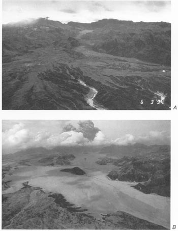
River valley filled in by pyroclastic flows from 1991 eruption of Mt. Pinatubo. Aerial views of Maloma and Marella River valleys comparing preeruption terrain (A) and posteruption terrain with fill of pyroclastic-flow deposits (B). Orientation of both views is northeast toward Mount Pinatubo, but B was taken from a position slightly east of and at higher altitude than that of A. Note hill surrounded by pyroclastic-flow deposits near center of B and compare with A. Main (east fork) channel of Marella River to east (right) of knob has been filled to a depth of about 200 m.
Both photographs by R.P. Hoblitt; A, June 3, 1991; B, June 23, 1991.)
This image is in the public domain in the United States because it only contains materials that originally came from the United States Geological Survey, an agency of the United States Department of the Interior. For more information, see the official USGS copyright policy.
|
היסטוריית הקובץ
ניתן ללחוץ על תאריך/שעה כדי לראות את הקובץ כפי שנראה באותו זמן.
| תאריך/שעה | תמונה ממוזערת | ממדים | משתמש | הערה | |
|---|---|---|---|---|---|
| נוכחית | 13:08, 8 במרץ 2006 | | 454 × 350 (23 ק"ב) | Magalhães | River valley filled in by pyroclastic flows from 1991 eruption of Mt. Pinatubo. Source: [http://pubs.usgs.gov/pinatubo/wescott/fig2.jpg Fig.2] on [http://pubs.usgs.gov/pinatubo/wescott] {{PD-USGov-Interior-USGS}} Mount Pinatubo |
שימוש בקובץ
הדף הבא משתמש בקובץ הזה:
שימוש גלובלי בקובץ
אתרי הוויקי השונים הבאים משתמשים בקובץ זה:
- שימוש באתר bg.wikipedia.org
- שימוש באתר bn.wikipedia.org
- שימוש באתר el.wikipedia.org
- שימוש באתר en.wikipedia.org
- שימוש באתר en.wikibooks.org
- שימוש באתר es.wikipedia.org
- שימוש באתר fi.wikipedia.org
- שימוש באתר fr.wikipedia.org
- שימוש באתר it.wikipedia.org
- שימוש באתר nl.wikipedia.org
- שימוש באתר ru.wikipedia.org
- שימוש באתר sk.wikipedia.org
- שימוש באתר sl.wikipedia.org
- שימוש באתר tl.wikipedia.org
- שימוש באתר tr.wikipedia.org
- שימוש באתר uk.wikipedia.org