קובץ:Wpdms usgs photo sacramento delta 2.jpg
אין גרסה ברזולוציה גבוהה יותר.
Wpdms_usgs_photo_sacramento_delta_2.jpg (700 × 520 פיקסלים, גודל הקובץ: 81 ק"ב, סוג MIME: image/jpeg)
| זהו קובץ שמקורו במיזם ויקישיתוף. תיאורו בדף תיאור הקובץ המקורי (בעברית) מוצג למטה. |
| תיאור |
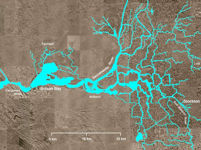
The Sacramento-San Joaquin River Delta of California - covering the right half of the map.
|
||||||||
| תאריך יצירה | |||||||||
| מקור | http://en.wikipedia.org/wiki/Image:Wpdms_usgs_photo_sacramento_delta_2.jpg | ||||||||
| יוצר | Matthew Trump | ||||||||
| אישורים והיתרים (שימוש חוזר בקובץ זה) |
English Wikipedia user Decumanus, בעל זכויות היוצרים על היצירה הזאת, מפרסם אותה בזאת תחת הרישיון הבא:
|
||||||||
| גרסאות אחרות | Derivative works of this file: California Grizzly Bear walking in the Delta Region.jpg |

en:Sacramento-San Joaquin River Delta
היסטוריית הקובץ
ניתן ללחוץ על תאריך/שעה כדי לראות את הקובץ כפי שנראה באותו זמן.
| תאריך/שעה | תמונה ממוזערת | ממדים | משתמש | הערה | |
|---|---|---|---|---|---|
| נוכחית | 06:21, 8 באוגוסט 2008 | | 520 × 700 (81 ק"ב) | Captndelta | {{Information |Description=The Sacramento-San Joaquin River Delta covers the right half of this image. The Sacramento River flows into the delta from the north and the San Joaquin River from the south. The Mokelumne River |
שימוש בקובץ
![]() אין בוויקיפדיה דפים המשתמשים בקובץ זה.
אין בוויקיפדיה דפים המשתמשים בקובץ זה.
שימוש גלובלי בקובץ
אתרי הוויקי השונים הבאים משתמשים בקובץ זה:
- שימוש באתר azb.wikipedia.org
- שימוש באתר de.wikipedia.org
- שימוש באתר en.wikipedia.org
- שימוש באתר es.wikipedia.org
- שימוש באתר eu.wikipedia.org
- שימוש באתר it.wikipedia.org
- שימוש באתר ml.wikipedia.org
- שימוש באתר nl.wikipedia.org
- שימוש באתר www.wikidata.org