קובץ:A Nearly Ice-Free Northwest Passage vir 2016222 lrg.jpg

לקובץ המקורי (6,136 × 4,272 פיקסלים, גודל הקובץ: 4.09 מ"ב, סוג MIME: image/jpeg)
| זהו קובץ שמקורו במיזם ויקישיתוף. תיאורו בדף תיאור הקובץ המקורי (בעברית) מוצג למטה. |
תקציר
| תיאור |
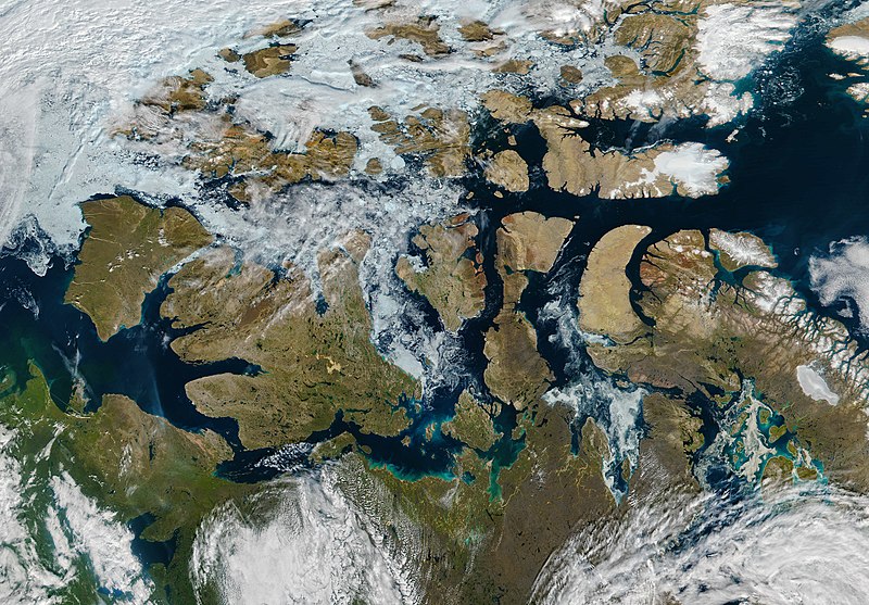
English: The Northwest Passage is a famed high-latitude sea route in the Arctic. The route meanders through the Canadian Arctic Archipelago, connecting the North Atlantic and Pacific Oceans. For most of the year, its waters are choked with sea ice. But by mid-August 2016, the passage was nearly ice-free.
The Visible Infrared Imaging Radiometer Suite (VIIRS) on the Suomi NPP satellite captured this image of the Northwest Passage on August 9, 2016. A path of open water can be traced almost the entire distance from the Amundsen Gulf to Baffin Bay, encountering a scattering of broken ice just east of Victoria Island. This is not the first Arctic summer with so much open water. According to NOAA, the more frequent opening of the Northwest Passage means that it is becoming an increasingly viable route for shipping.Deutsch: Die Nordwestpassage ist eine berühmte Schifffahrtsroute in den hohen Breiten der Arktis; sie schlängelt sich durch den Kanadisch-arktischen Archipel und verbindet den Nordatlantik mit dem Pazifischen Ozean. Den größten Teil des Jahres sind diese Gewässer eisbedeckt, doch Mitte August 2016 war die Passage fast durchgehend eisfrei.
Die Visible Infrared Imaging Radiometer Suite (VIIRS) auf dem Suomi NPP Satellite zeichnete am 9. August 2016 dieses Bid auf. Ein Pfad mit offenem Fahrwasser reichte dabei fast die gesamte Strecke vom Amundsengolf bis zur Baffininsel, nur direkt östlich von Victoria Island sind Eisreste vorhanden. 2016 ist nicht der erste arktische Sommer mit derart ausgedehnten offenen Wasserflächen. Nach Ansicht der NOAA bedeutet die häufigere Öffnung des Wasserweges, dass die Nordwestpassage zunehmend zu einer verlässlichen Schifffahrtsverbindung wird. |
| תאריך יצירה | |
| מקור | http://earthobservatory.nasa.gov/NaturalHazards/view.php?id=88597 |
| יוצר | NASA image by Jeff Schmaltz, LANCE/EOSDIS Rapid Response, using VIIRS data from the Suomi National Polar-orbiting Partnership satellite. Suomi NPP is the result of a partnership between NASA, the National Oceanic and Atmospheric Administration, and the Department of Defense. Caption by Kathryn Hansen. |
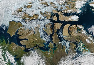
| גרסאות אחרות | File:A Nearly Ice-Free Northwest Passage vir 2016222 (annotated).jpg |
.jpg)
References and Related Reading
- NASA Earth Observatory (2015, September 13) Partial Opening of the Northwest Passage.
- National Snow & Ice Data Center (2016, August 16) Late summer in the Arctic, sea ice melt continues. Accessed August 18, 2016.
- NOAA Environmental Visualization Laboratory (2016, August 11) Suomi NPP sees the Northwest Passage. Accessed August 18, 2016.
רישיון
| קובץ זה נמצא ברשות הציבור מכיוון שהוא נוצר על ידי נאס"א. מדיניות זכויות היוצרים של נאס"א קובעת ש"חומרים של NASA אינם מוגנים בזכויות יוצרים אלא אם צוין אחרת". (דף מדיניות זכויות היוצרים ב-NASA או מדיניות שימוש בתמונות ב-JPL). | ||
 |
אזהרות:
|
היסטוריית הקובץ
ניתן ללחוץ על תאריך/שעה כדי לראות את הקובץ כפי שנראה באותו זמן.
| תאריך/שעה | תמונה ממוזערת | ממדים | משתמש | הערה | |
|---|---|---|---|---|---|
| נוכחית | 01:57, 20 באוגוסט 2016 | | 4,272 × 6,136 (4.09 מ"ב) | Matthiasb | {{Information |Description ={{en|1=The Northwest Passage is a famed high-latitude sea route in the Arctic. The route meanders through the Canadian Arctic Archipelago, connecting the North Atlantic and Pacific Oceans. For most of the year, its waters... |
שימוש בקובץ
הדפים הבאים משתמשים בקובץ הזה:
שימוש גלובלי בקובץ
אתרי הוויקי השונים הבאים משתמשים בקובץ זה:
- שימוש באתר en.wikipedia.org
- שימוש באתר fi.wikipedia.org
- שימוש באתר id.wikipedia.org
- שימוש באתר ky.wikipedia.org