קובץ:Alemannic-Dialects-Map-English.png
גודל התצוגה המקדימה הזאת: 800 × 571 פיקסלים. רזולוציות אחרות: 320 × 229 פיקסלים | 640 × 457 פיקסלים | 1,024 × 731 פיקסלים | 1,400 × 1,000 פיקסלים.
לקובץ המקורי (1,400 × 1,000 פיקסלים, גודל הקובץ: 838 ק"ב, סוג MIME: image/png)
| זהו קובץ שמקורו במיזם ויקישיתוף. תיאורו בדף תיאור הקובץ המקורי (בעברית) מוצג למטה. |
| תיאור |
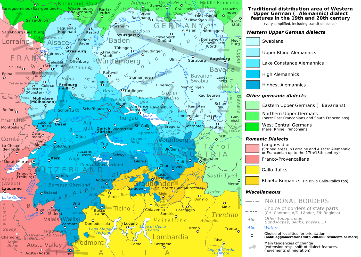
English: The traditional distribution area of the western upper German (=alemannic) dialects in the 19th and 20th century. Source: Mainly these articles in the German wikipedia: * Alemannische Dialekte * Grenzorte des alemannischen Dialektraums * Traditionell rätoromanischsprachiges Gebiet Graubündens and * Sprachen und Dialekte in der Region Elsass, plus the (newer) literature, which is mentioned there. This area, having been quite stable for at least some 300 years up to the 19th century, saw consecutively more or less strong changes by industrialisation, population growth, migrations and political developments. Deutsch: Das traditionelle Verbreitungsgebiet der westoberdeutschen (=alemannischen) Dialekte im 19. und 20. Jahrhundert. Grundlage: vor allem diese Artikel der deutschsprachigen Wikipedia: * Alemannische Dialekte * Grenzorte des alemannischen Dialektraums * Traditionell rätoromanischsprachiges Gebiet Graubündens und * Sprachen und Dialekte in der Region Elsass, sowie die dort jeweils genannte (jüngere) Literatur. Das bis ins 19. Jahrhundert für mindestens etwa 300 Jahre stabile Gebiet erfuhr nachfolgend durch Industrialisierung, Bevölkerungszuwächse und -bewegungen sowie politische Entwicklungen mehr oder weniger starke Änderungen. Français : Le secteur de distribution traditionnel des dialectes allemands supérieurs occidentaux (=alémannique) au 19e et 20e siècle. Source : Principalement ces articles dans le wikipedia allemand : * Alemannische Dialekte * Grenzorte des alemannischen Dialektraums * Traditionell rätoromanischsprachiges Gebiet Graubündens et * Sprachen und Dialekte in der Region Elsass, plus la littérature (plus jeune), qui est mentionnée là. Ce secteur, après avoir été stable jusqu'au 19e siècle pour au moins environ 300 années, scie consécutivement des changements plus ou moins forts par industrialisation, croissance démographique, migrations et développements politiques. Italiano: Area di distribuzione storica delle varianti linguistiche alto-tedesche occidentali(alemanniche) nel diciannovesimo e ventesimo secolo. Fonti: questa mappa si basa prevalentemente sui seguenti articoli in Wikipedia di lingua tedesca: * Alemannische Dialekte * Grenzorte des alemannischen Dialektraums * Traditionell rätoromanischsprachiges Gebiet Graubündens and * Sprachen und Dialekte in der Region Elsass, in aggiunta alla letteratura più recente menzionata in quegli articoli. Questa area, dopo essere rimasta piuttosto stabile per circa trecento anni fino all'inizio del diciannovesimo secolo, ha poi visto trasformazioni di diversa intensità causate dall'industrializzazione, dalla crescita demografica, dai processi migratori e dagli sviluppi politici. |
| תאריך יצירה | (UTC) |
| מקור | |
| יוצר |
|
| גרסאות אחרות |
PNG:
PNG:
SVG:
SVG: SVG:
|


| זוהי תמונה מרוטשת, זאת אומרת שהתמונה שונתה בצורה דיגיטלית מהמקור. Modifications: PNG-Version. את התמונה המקורית ניתן לראות ב: Alemannic-Dialects-Map-English.svg. השינוי בוצע על ידי Testtube.
|
אני, בעל זכויות היוצרים על היצירה הזאת, מפרסם אותה בזאת תחת הרישיונות הבאים:
הקובץ הזה מתפרסם לפי תנאי רישיונות קריאייטיב קומונז ייחוס-שיתוף זהה 3.0 לא מותאם, 2.5 כללי, 2.0 כללי ו־1.0 כללי.
- הנכם רשאים:
- לשתף – להעתיק, להפיץ ולהעביר את העבודה
- לערבב בין עבודות – להתאים את העבודה
- תחת התנאים הבאים:
- ייחוס – יש לתת ייחוס הולם, לתת קישור לרישיון, ולציין אם נעשו שינויים. אפשר לעשות את זה בכל צורה סבירה, אבל לא בשום צורה שמשתמע ממנה שמעניק הרישיון תומך בך או בשימוש שלך.
- שיתוף זהה – אם תיצרו רמיקס, תשנו, או תבנו על החומר, חובה עליכם להפיץ את התרומות שלך לפי תנאי רישיון זהה או תואם למקור.

|
מוענקת בכך הרשות להעתיק, להפיץ או לשנות את המסמך הזה, לפי תנאי הרישיון לשימוש חופשי במסמכים של גנו, גרסה 1.2 או כל גרסה מאוחרת יותר שתפורסם על־ידי המוסד לתוכנה חופשית; ללא פרקים קבועים, ללא טקסט עטיפה קדמית וללא טקסט עטיפה אחורית. עותק של הרישיון כלול בפרק שכותרתו הרישיון לשימוש חופשי במסמכים של גנו. |
הנכם מוזמנים לבחור את הרישיון הרצוי בעיניכם.
יומן העלאה מקורי
This image is a derivative work of the following images:
- File:Alemannic-Dialects-Map-English.svg licensed with Cc-by-sa-3.0,2.5,2.0,1.0, GFDL
- 2010-08-11T20:11:45Z Testtube 1400x1000 (482460 Bytes) Bugfix
- 2010-08-11T19:44:48Z Testtube 1400x1000 (482811 Bytes) Bugfix
- 2010-08-11T15:14:04Z Testtube 1400x1000 (482540 Bytes) {{Information |Description={{en|1=The traditional distribution area of the western upper german (=alemannic) dialects in the 19th and 20th century. Source: Mainly these articles in the german wikipedia: * [http://de.wikipedi
Uploaded with derivativeFX
היסטוריית הקובץ
ניתן ללחוץ על תאריך/שעה כדי לראות את הקובץ כפי שנראה באותו זמן.
| תאריך/שעה | תמונה ממוזערת | ממדים | משתמש | הערה | |
|---|---|---|---|---|---|
| נוכחית | 20:01, 19 באוגוסט 2010 | | 1,000 × 1,400 (838 ק"ב) | Testtube~commonswiki | Bugfix. |
| 23:10, 18 באוגוסט 2010 |  | 1,000 × 1,400 (837 ק"ב) | Testtube~commonswiki | {{Information |Description={{en|1=The traditional distribution area of the western upper german (=alemannic) dialects in the 19th and 20th century. Source: Mainly these articles in the german wikipedia: * [http://de.wikipedia.org/wiki/Alemannische_Diale |
שימוש בקובץ
הדף הבא משתמש בקובץ הזה:
שימוש גלובלי בקובץ
אתרי הוויקי השונים הבאים משתמשים בקובץ זה:
- שימוש באתר am.wikipedia.org
- שימוש באתר ar.wikipedia.org
- שימוש באתר azb.wikipedia.org
- שימוש באתר be.wikipedia.org
- שימוש באתר bg.wikipedia.org
- שימוש באתר br.wikipedia.org
- שימוש באתר bs.wikipedia.org
- שימוש באתר cdo.wikipedia.org
- שימוש באתר cs.wikipedia.org
- שימוש באתר da.wikipedia.org
- שימוש באתר de.wikipedia.org
- שימוש באתר el.wikipedia.org
- שימוש באתר en.wikipedia.org
- שימוש באתר et.wikipedia.org
- שימוש באתר fa.wikipedia.org
- שימוש באתר fi.wikipedia.org
- שימוש באתר gl.wikipedia.org
- שימוש באתר hr.wikipedia.org
- שימוש באתר hu.wikipedia.org
- שימוש באתר id.wikipedia.org
- שימוש באתר it.wikipedia.org
- שימוש באתר ja.wikipedia.org
- שימוש באתר ku.wikipedia.org
- שימוש באתר lij.wikipedia.org
- שימוש באתר lt.wikipedia.org
- שימוש באתר lv.wikipedia.org
- שימוש באתר mk.wikipedia.org
- שימוש באתר nl.wikipedia.org
- שימוש באתר no.wikipedia.org
- שימוש באתר pl.wikipedia.org
- שימוש באתר ru.wikipedia.org
- שימוש באתר sat.wikipedia.org
- שימוש באתר sh.wikipedia.org
- שימוש באתר simple.wikipedia.org
- שימוש באתר sl.wikipedia.org
- שימוש באתר sq.wikipedia.org
- שימוש באתר sv.wikipedia.org