קובץ:Arabian Peninsula (orthographic projection).png

גודל התצוגה המקדימה הזאת: 600 × 600 פיקסלים. רזולוציות אחרות: 240 × 240 פיקסלים | 480 × 480 פיקסלים | 768 × 768 פיקסלים | 1,024 × 1,024 פיקסלים | 2,000 × 2,000 פיקסלים.
לקובץ המקורי (2,000 × 2,000 פיקסלים, גודל הקובץ: 666 ק"ב, סוג MIME: image/png)
| זהו קובץ שמקורו במיזם ויקישיתוף. תיאורו בדף תיאור הקובץ המקורי (בעברית) מוצג למטה. |
.png)
.png?uselang=he)
תקציר
| תיאור |
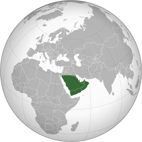
English: The Arabian Peninsula العربية: شبه الجزيرة العربية |
| תאריך יצירה | |
| מקור | נוצר על־ידי מעלה היצירה |
| יוצר | Afrogindahood |
רישיון
| This map is ineligible for copyright and therefore in the public domain, because it consists entirely of information that is common property and contains no original authorship. For more information, see Commons:Threshold of originality § Maps.
|
היסטוריית הקובץ
ניתן ללחוץ על תאריך/שעה כדי לראות את הקובץ כפי שנראה באותו זמן.
| תאריך/שעה | תמונה ממוזערת | ממדים | משתמש | הערה | |
|---|---|---|---|---|---|
| נוכחית | 17:14, 7 במרץ 2023 | | 2,000 × 2,000 (666 ק"ב) | Treetoes023 | Reverted to version as of 23:11, 6 January 2020 (UTC): This version shows the geographic Arabian Peninsula. |
| 00:24, 25 בינואר 2020 |  | 2,000 × 2,000 (399 ק"ב) | Ham105 | Reverted to version as of 03:49, 7 March 2015 (UTC) | |
| 02:11, 7 בינואר 2020 |  | 2,000 × 2,000 (666 ק"ב) | Sariyr | Reverted to version as of 22:23, 4 January 2020 (UTC): Northern border line between the Gulf of Aqaba and the Kuwait Bay. | |
| 07:06, 5 בינואר 2020 |  | 2,000 × 2,000 (399 ק"ב) | Ham105 | Reverted to version as of 03:49, 7 March 2015 (UTC) unsourced - take it to the discussion page | |
| 01:23, 5 בינואר 2020 |  | 2,000 × 2,000 (666 ק"ב) | Sariyr | Reverted to version as of 02:46, 4 January 2020 (UTC): Northern border line between the Gulf of Akaba an the Kuwait Bay. | |
| 18:37, 4 בינואר 2020 |  | 2,000 × 2,000 (399 ק"ב) | Ham105 | Reverted to version as of 03:49, 7 March 2015 (UTC) | |
| 05:46, 4 בינואר 2020 |  | 2,000 × 2,000 (666 ק"ב) | Sariyr | Northern border line between the Gulf of Akaba an the Kuwait Bay. | |
| 06:49, 7 במרץ 2015 |  | 2,000 × 2,000 (399 ק"ב) | Afrogindahood | User created page with UploadWizard |
שימוש בקובץ
הדף הבא משתמש בקובץ הזה:
שימוש גלובלי בקובץ
אתרי הוויקי השונים הבאים משתמשים בקובץ זה:
- שימוש באתר ar.wikipedia.org
- שימוש באתר arz.wikipedia.org
- שימוש באתר azb.wikipedia.org
- שימוש באתר bn.wikipedia.org
- שימוש באתר ckb.wikipedia.org
- שימוש באתר cs.wikipedia.org
- שימוש באתר el.wikiversity.org
- שימוש באתר en.wikipedia.org
- שימוש באתר fa.wikipedia.org
- שימוש באתר hy.wikipedia.org
- שימוש באתר hyw.wikipedia.org
- שימוש באתר id.wikipedia.org
- שימוש באתר it.wikivoyage.org
- שימוש באתר kn.wikipedia.org
- שימוש באתר mrj.wikipedia.org
- שימוש באתר pnb.wikipedia.org
- שימוש באתר ps.wikipedia.org
- שימוש באתר pt.wikipedia.org
- שימוש באתר sc.wikipedia.org
- שימוש באתר si.wikipedia.org
- שימוש באתר sl.wikipedia.org
- שימוש באתר sr.wikipedia.org
- שימוש באתר th.wikipedia.org
- שימוש באתר ur.wikipedia.org
- שימוש באתר uz.wikipedia.org
- שימוש באתר vi.wikipedia.org
.png)