לקובץ המקורי(1,545 × 1,242 פיקסלים, גודל הקובץ: 187 ק"ב, סוג MIME‏: image/gif, בלולאה, 14 תמונות, 44 שניות)

ויקישיתוף זהו קובץ שמקורו במיזם ויקישיתוף. תיאורו בדף תיאור הקובץ המקורי (בעברית) מוצג למטה.
This image could be re-created using vector graphics as an SVG file. This has several advantages; see Commons:Media for cleanup for more information. If an SVG form of this image is available, please upload it and afterwards replace this template with {{vector version available|new image name}}. It is recommended to name the SVG file "Breakup of Yugoslavia.svg" - then the template Vector version available (or Vva) does not need the new image name parameter.

תקציר

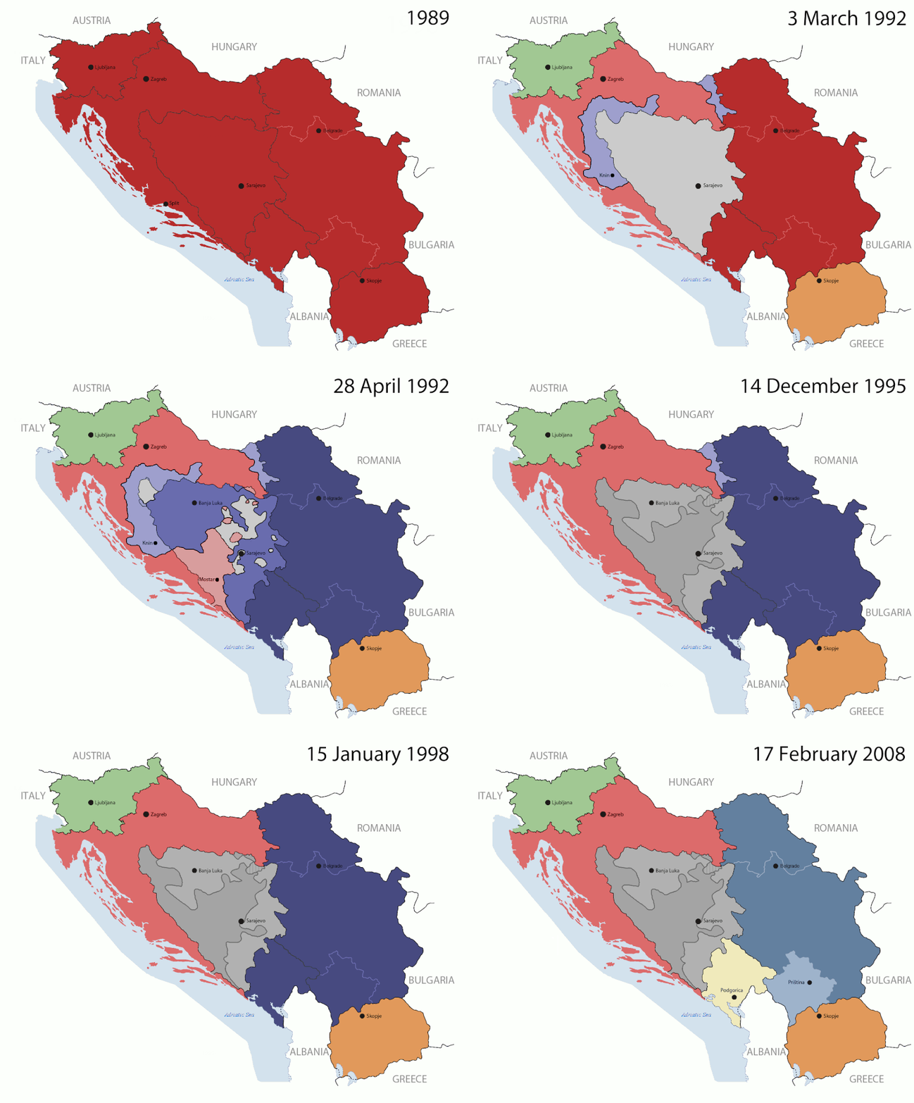
Key:

Yugoslavia (1943–1992) SFR Yugoslavia
Croatia (1991–present) Croatia
Herzeg-Bosnia (1992–1994)
UNTAES (1996–1998)
Federal Republic of Yugoslavia / Serbia and Montenegro (1992–2006) Serbia and Montenegro
Republika Srpska (1992–present) Republika Srpska
Serbian Krajina (1991–1995/96)
Republic of Bosnia and Herzegovina (1992–1995)
Bosnia and Herzegovina (1998–present) Bosnia and Herzegovina
Western Bosnia (1993–1995)
Serbia (2006–present) Serbia
Kosovo (under UNMIK control 1999–present; declaration of independence 2008) Kosovo
Montenegro (2006–present) Montenegro
Macedonia (1991–present) Macedonia
Slovenia (1991–present) Slovenia


תיאור

This is an animated GIF that shows the stages of the breakup of the SFR Yugoslavia in the 90's and 2000's. The map based off Morwen's map of the divisions of the SFRY, Which is licensed by the GFDL. The source for the dates of independence is the CIA World Factbook. These maps do not now show the Inter-Entity Boundary Line (IEBL) and/or the entities that are separated by it. The IEBL has been drawn based on this CIA map; the Brčko District has been drawn based on Image:BH municipality location.gif, by user:Ante Perkovic. I might add them in the future.

Since the original map was GFDL, this image is as well.

A map depicting Kosovo's final status is ready once it takes effect.


Changelog for versions 2/3:

Here are some changes in this new build of the map:

  • The Kosovo boundary has been given a shade of red instead of the previous UN blue since they are a province of Serbia under UNIMIK control.
  • Montenegro's color has been changed to a golden shade close to what's on the flag.
  • The IEBL and the Brčko District has been redrawn because I deleted the original map; the color for the Republika Srpska is lighter.
  • The dates are at the top left hand corner of the map instead of the bottom.
  • I have taken a new approach as to the boundaries. Each part of Yugoslavia now shows the boundary on the maps starting the year they broke away. I feel this change helps readers understand the breakup better.
  • The SFRY and the FRY are in different shades since the FRY was never accepted as the successor to the former by the UN.
  • The colors for the entities of BiH have been removed as to not confuse people into thinking that they are independent states. What remains is the IEBL with both entities in green.
  • The Kosovo boundary is finally in hash marks!
  • The Brčko District has been removed. The sale is too small to show accurately.

Changelog for version 4:

  • The map is larger!
  • The image has been rebuilt to include the eastern part of FYR Macedonia.
  • The image has been updated to take in Kosovo's new status.
  • The IEBL is now a darker line.
  • Montenegro, Kosovo, and FRY/SCG/Serbia have new colors!

Changelog for version 5:

  • Rebuilt
  • Larger map: size of base image
  • Accurate Inter-Entity Boundary Line
תאריך יצירה 24 July 2006 (orginal upload date)
מקור Made by Hoshie; see above for more details on sources.
יוצר Hoshie
גרסאות אחרות

רישיון

GNU head מוענקת בכך הרשות להעתיק, להפיץ או לשנות את המסמך הזה, לפי תנאי הרישיון לשימוש חופשי במסמכים של גנו, גרסה 1.2 או כל גרסה מאוחרת יותר שתפורסם על־ידי המוסד לתוכנה חופשית; ללא פרקים קבועים, ללא טקסט עטיפה קדמית וללא טקסט עטיפה אחורית. עותק של הרישיון כלול בפרק שכותרתו הרישיון לשימוש חופשי במסמכים של גנו.
w:he:Creative Commons
ייחוס שיתוף זהה
הקובץ הזה מתפרסם לפי תנאי רישיון קריאייטיב קומונז ייחוס-שיתוף זהה 3.0 לא מותאם.
הנכם רשאים:
  • לשתף – להעתיק, להפיץ ולהעביר את העבודה
  • לערבב בין עבודות – להתאים את העבודה
תחת התנאים הבאים:
  • ייחוס – יש לתת ייחוס הולם, לתת קישור לרישיון, ולציין אם נעשו שינויים. אפשר לעשות את זה בכל צורה סבירה, אבל לא בשום צורה שמשתמע ממנה שמעניק הרישיון תומך בך או בשימוש שלך.
  • שיתוף זהה – אם תיצרו רמיקס, תשנו, או תבנו על החומר, חובה עליכם להפיץ את התרומות שלך לפי תנאי רישיון זהה או תואם למקור.
תבנית רישוי זו הוספה לקובץ כחלק מעדכון רישיון GFDL.

כיתובים

נא להוסיף משפט שמסביר מה הקובץ מייצג

פריטים שמוצגים בקובץ הזה

מוצג

checksum אנגלית

05ca2aefea8406b809968643552d5095c847a42f

הוגדר לפי: SHA-1 אנגלית

191,625 בית

44 שנייה

1,242 פיקסל

1,545 פיקסל

היסטוריית הקובץ

ניתן ללחוץ על תאריך/שעה כדי לראות את הקובץ כפי שנראה באותו זמן.

(החדשות ביותר | הישנות ביותר) צפייה ב: (10 הבאות | ) (10 | 20 | 50 | 100 | 250 | 500)
תאריך/שעהתמונה ממוזערתממדיםמשתמשהערה
נוכחית10:40, 17 ביולי 2016תמונה ממוזערת לגרסה מ־10:40, 17 ביולי 2016‪1,242 × 1,545‬ (187 ק"ב)מפתח-רשימהReverted to version as of 17:22, 21 August 2015 (UTC)
20:22, 21 באוגוסט 2015תמונה ממוזערת לגרסה מ־20:22, 21 באוגוסט 2015‪1,158 × 1,463‬ (1.81 מ"ב)BraganzaReverted to version as of 03:57, 19 January 2010
20:22, 21 באוגוסט 2015תמונה ממוזערת לגרסה מ־20:22, 21 באוגוסט 2015‪1,242 × 1,545‬ (187 ק"ב)BraganzaReverted to version as of 01:02, 19 December 2011
20:15, 21 באוגוסט 2015תמונה ממוזערת לגרסה מ־20:15, 21 באוגוסט 2015‪95 × 120‬ (3 ק"ב)Braganza03:57, 19. Jan. 2010
04:02, 19 בדצמבר 2011תמונה ממוזערת לגרסה מ־04:02, 19 בדצמבר 2011‪1,242 × 1,545‬ (187 ק"ב)DIREKTORAdded details
21:09, 27 ביולי 2011תמונה ממוזערת לגרסה מ־21:09, 27 ביולי 2011‪1,242 × 1,545‬ (170 ק"ב)DIREKTORSmall fixes
20:28, 27 ביולי 2011תמונה ממוזערת לגרסה מ־20:28, 27 ביולי 2011‪1,242 × 1,545‬ (171 ק"ב)DIREKTORAdded UNMIK
19:38, 27 ביולי 2011תמונה ממוזערת לגרסה מ־19:38, 27 ביולי 2011‪1,242 × 1,545‬ (165 ק"ב)DIREKTORDates for the last two frames.
15:10, 27 ביולי 2011תמונה ממוזערת לגרסה מ־15:10, 27 ביולי 2011‪1,242 × 1,545‬ (149 ק"ב)DIREKTORLighter shade for country names
19:59, 26 ביולי 2011תמונה ממוזערת לגרסה מ־19:59, 26 ביולי 2011‪1,242 × 1,545‬ (170 ק"ב)DIREKTORHigher res plus details
(החדשות ביותר | הישנות ביותר) צפייה ב: (10 הבאות | ) (10 | 20 | 50 | 100 | 250 | 500)

הדפים הבאים משתמשים בקובץ הזה:

שימוש גלובלי בקובץ

אתרי הוויקי השונים הבאים משתמשים בקובץ זה:

צפו בשימושים בקובץ זה במיזמי ויקימדיה נוספים.

מטא־נתונים