קובץ:Capt John Smith's map of Virginia 1624.jpg

גודל התצוגה המקדימה הזאת: 777 × 599 פיקסלים. רזולוציות אחרות: 311 × 240 פיקסלים | 622 × 480 פיקסלים | 996 × 768 פיקסלים | 1,280 × 987 פיקסלים | 2,520 × 1,944 פיקסלים.
לקובץ המקורי (2,520 × 1,944 פיקסלים, גודל הקובץ: 1.02 מ"ב, סוג MIME: image/jpeg)
| זהו קובץ שמקורו במיזם ויקישיתוף. תיאורו בדף תיאור הקובץ המקורי (בעברית) מוצג למטה. |
תקציר
| כותר |
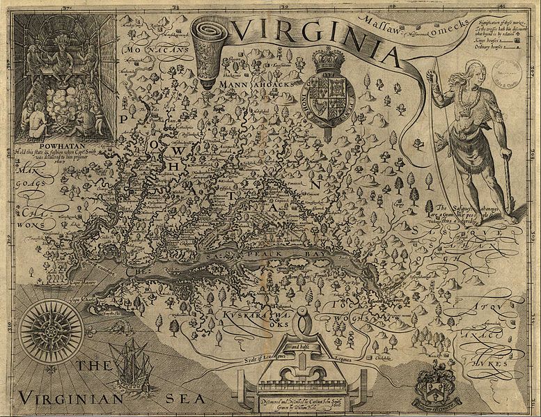
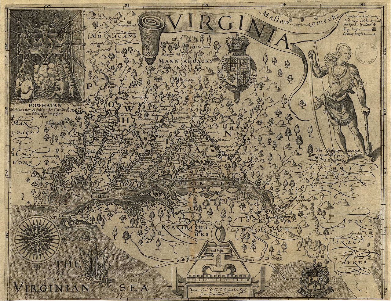
A Map of Virginia: With a Description of the Countrey, the Commodities, People, Government and Religion |
|||||||||
| Map legend |
Discovered and discribed by Captaijn John Smith 1606. Graven by William Hole. |
|||||||||
| תאריך יצירה |
|
|||||||||
| מקור | ||||||||||
| יוצר |
William Hole (engraver, d. 1624) |
|||||||||
| אישורים והיתרים (שימוש חוזר בקובץ זה) |
|
|||||||||
| Geotemporal data | ||||||||||
| תאריך מתואר |
|
|||||||||
| Map location |
Virginia, United States |
|||||||||
| Map type |
Historical map |
|||||||||
| Bounding box |
|
|||||||||
| Georeferencing | ||||||||||
| Bibliographic data | ||||||||||
| פרסום |
A Map of Virginia: With a Description of the Countrey, the Commodities, People, Government and Religion |
|||||||||
| יוצר |
Captain John Smith |
|||||||||
| שפה |
English |
|||||||||
| מיקום הוצאה |
Oxford |
|||||||||
| מפרסם |
Joseph Barnes |
|||||||||
| Archival data | ||||||||||
| ממדים | גובה: 32 ס"מ; רוחב: 41 ס"מ | |||||||||
| טכניקה | תחריט על נייר | |||||||||
רישיון
|
יצירה זו נמצאת בנחלת הכלל במדינת המקור ובמדינות אחרות בהם תקופת זכויות היוצרים היא משך חיי היוצר ו-100 שנה (או פחות) מפטירתו.
| |
| הקובץ הזה זוהה כקובץ חופשי מכל מגבלה ידועה תחת חוק זכויות היוצרים, כולל כל הזכויות הקשורות והסמוכות. | |
היסטוריית הקובץ
ניתן ללחוץ על תאריך/שעה כדי לראות את הקובץ כפי שנראה באותו זמן.
| תאריך/שעה | תמונה ממוזערת | ממדים | משתמש | הערה | |
|---|---|---|---|---|---|
| נוכחית | 03:24, 20 ביוני 2011 | | 1,944 × 2,520 (1.02 מ"ב) | Frank Schulenburg | Source: http://www.virtualjamestown.org/maps1.html |
| 23:03, 16 ביוני 2010 |  | 849 × 1,000 (242 ק"ב) | MarmadukePercy | {{Information |Description={{en|1=John Smith's map of Virginia from "The Generall Historie of Virginia, New-England, and the Summer Isles," published in London, 1624. Courtesy of University of North Carolina Libraries.}} |Source=http://www.learnnc.org/lp/ |
שימוש בקובץ
הדפים הבאים משתמשים בקובץ הזה:
שימוש גלובלי בקובץ
אתרי הוויקי השונים הבאים משתמשים בקובץ זה:
- שימוש באתר en.wikipedia.org
- שימוש באתר fr.wikipedia.org
- שימוש באתר fy.wikipedia.org
- שימוש באתר hy.wikipedia.org
- שימוש באתר incubator.wikimedia.org
- שימוש באתר it.wikipedia.org
- שימוש באתר la.wikipedia.org