קובץ:Circum-Arctic Map of Permafrost and Ground Ice Conditions.png
גודל התצוגה המקדימה הזאת: 534 × 599 פיקסלים. רזולוציות אחרות: 214 × 240 פיקסלים | 428 × 480 פיקסלים | 683 × 766 פיקסלים.
לקובץ המקורי (683 × 766 פיקסלים, גודל הקובץ: 29 ק"ב, סוג MIME: image/png)
| זהו קובץ שמקורו במיזם ויקישיתוף. תיאורו בדף תיאור הקובץ המקורי (בעברית) מוצג למטה. |

|
יש ליצור מחדש את התמונה map הזו באמצעות גרפיקה וקטורית כדוגמת קובץ SVG. לפעולה זו מספר יתרונות, כפי שניתן לקרוא (באנגלית) בדף Commons:Media for cleanup. אם ברשותכם קובץ SVG, אנא העלו אותו. לאחר מכן, החליפו תבנית זו בתבנית
{{vector version available|שם הקובץ.svg}} |
תקציר
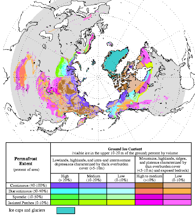
| תיאור | Circum-Arctic Map of Permafrost and Ground Ice Conditions |
| תאריך יצירה | 1998, revised February 2001 |
| מקור | http://nsidc.org/data/docs/fgdc/ggd318_map_circumarctic/index.html |
| יוצר | Brown, J., O.J. Ferrians, Jr., J.A. Heginbottom, and E.S. Melnikov. 1998, revised February 2001. Circum-arctic map of permafrost and ground ice conditions. Boulder, CO: National Snow and Ice Data Center/World Data Center for Glaciology |
רישיון
This work is in the public domain in the United States because it is a work prepared by an officer or employee of the United States Government as part of that person’s official duties under the terms of Title 17, Chapter 1, Section 105 of the US Code.
Note: This only applies to original works of the Federal Government and not to the work of any individual U.S. state, territory, commonwealth, county, municipality, or any other subdivision. This template also does not apply to postage stamp designs published by the United States Postal Service since 1978. (See § 313.6(C)(1) of Compendium of U.S. Copyright Office Practices). It also does not apply to certain US coins; see The US Mint Terms of Use.
|
 | |
| הקובץ הזה זוהה כקובץ חופשי מכל מגבלה ידועה תחת חוק זכויות היוצרים, כולל כל הזכויות הקשורות והסמוכות. | ||
היסטוריית הקובץ
ניתן ללחוץ על תאריך/שעה כדי לראות את הקובץ כפי שנראה באותו זמן.
| תאריך/שעה | תמונה ממוזערת | ממדים | משתמש | הערה | |
|---|---|---|---|---|---|
| נוכחית | 16:21, 23 במרץ 2015 | | 766 × 683 (29 ק"ב) | RokerHRO | optipng -o7 -i0 → 35.32% decrease |
| 21:40, 21 במאי 2008 |  | 766 × 683 (44 ק"ב) | Sagredo | {{Information |Description=Circum-Arctic Map of Permafrost and Ground Ice Conditions |Source=http://nsidc.org/data/docs/fgdc/ggd318_map_circumarctic/index.html |Date=1998, revised February 2001 |Author=Brown, J., O.J. Ferrians, Jr., J.A. Heginbottom, and |
שימוש בקובץ
הדפים הבאים משתמשים בקובץ הזה:
- קפאת-עד
- ויקיפדיה:ערכים מומלצים/המלצות קודמות/אפריל 2022
- ויקיפדיה:ערכים מומלצים/המלצות קודמות/פברואר 2017
- ויקיפדיה:ערכים מומלצים/המלצות קודמות/פברואר 2024
- תבנית:ערך מומלץ 14 בפברואר 2024
- תבנית:ערך מומלץ 19 בפברואר 2017
- תבנית:ערך מומלץ 20 בפברואר 2017
- תבנית:ערך מומלץ 4 באפריל 2022
- פורטל:ערכים מומלצים/ערכים/קפאת-עד
שימוש גלובלי בקובץ
אתרי הוויקי השונים הבאים משתמשים בקובץ זה:
- שימוש באתר bxr.wikipedia.org
- שימוש באתר ca.wikipedia.org
- שימוש באתר ckb.wikipedia.org
- שימוש באתר cs.wikipedia.org
- שימוש באתר de.wikipedia.org
- שימוש באתר el.wikipedia.org
- שימוש באתר en.wikipedia.org
- שימוש באתר eo.wikipedia.org
- שימוש באתר eu.wikipedia.org
- שימוש באתר fa.wikipedia.org
- שימוש באתר fr.wikipedia.org
- שימוש באתר gl.wikipedia.org
- שימוש באתר ha.wikipedia.org
- שימוש באתר hr.wikipedia.org
- שימוש באתר id.wikipedia.org
- שימוש באתר it.wikipedia.org
- שימוש באתר ko.wikipedia.org
- שימוש באתר ms.wikipedia.org
- שימוש באתר ro.wikipedia.org
- שימוש באתר ru.wikipedia.org
- שימוש באתר simple.wikipedia.org
- שימוש באתר si.wikipedia.org
- שימוש באתר sl.wikipedia.org
- שימוש באתר sv.wikipedia.org
- שימוש באתר tr.wikipedia.org
- שימוש באתר uk.wikipedia.org
- שימוש באתר zh.wikipedia.org