קובץ:Comparison satellite navigation orbits.svg

לקובץ המקורי(קובץ SVG, הגודל המקורי: 512 × 512 פיקסלים, גודל הקובץ: 42 ק"ב)

הצגת תמונה זו בשפה .
ויקישיתוף זהו קובץ שמקורו במיזם ויקישיתוף. תיאורו בדף תיאור הקובץ המקורי (בעברית) מוצג למטה.
קובץ זה הוא אנימציית SVG. התצוגה המקדימה לעיל עשויה להיות לא נכונה או לא מלאה. כדי להנות מיכולות אינטרקטיביות פתחו את media:Comparison satellite navigation orbits.svg בדפדפן או תוכנה התומכת בהצגת אנימציית SVG, כדוגמת, אופרה or אינטרנט אקספלורר עם תוסף Adobe SVG.

Templates:Animated SVG/I18n
العربية | Boarisch | বাংলা | català | čeština | Deutsch | Deutsch (Sie-Form)‎ | English | español | فارسی | suomi | français | galego | עברית | हिन्दी | magyar | հայերեն | íslenska | italiano | 日本語 | 한국어 | lietuvių | македонски | മലയാളം | Plattdüütsch | Nederlands | occitan | português | português do Brasil | русский | sicilianu | slovenščina | svenska | ไทย | українська | 中文 | 中文(简体)‎ | 中文(繁體)‎ | +/−

תקציר

תיאור
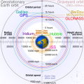
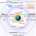
English: Comparison of GPS, GLONASS, Galileo and COMPASS (medium Earth orbit satellites) orbits with International Space Station, Hubble Space Telescope, geostationary and graveyard orbits, and the nominal size of the Earth.


For this diagram, the 3-dimensional aspect of orbits have been flattened. For instance, the view of the Earth depicted is looking down to the North Pole which makes the orbit representations appear to be equatorial. While this is accurate for geostationary orbits, other orbits listed are actually at significant inclinations. The inclination of Iridium orbits is at 86.4° which is nearly perpendicular to the diagrammed plane. Looking down to the North Pole from this zenith, a polar orbit of 90° inclination would actually appear as a straight line.
Français : Comparaison des orbites GPS, GLONASS, Galileo, Iridium et Beidou avec celles de la Station spatiale internationale et Hubble ainsi que l'orbite géostationnaire, l'orbite de rebut et la taille de la Terre.


Pour ce diagramme, l'aspect tridimensionnel des orbites a été ignoré : tout est aplati. La Terre est représentée avec le pôle Nord au centre, ce qui fait que les orbites semblent équatoriales. Ceci est correct dans le cas des orbites géostationnaires, mais les autres sont en réalité inclinées. Les satellites Iridium sont le cas le plus extrême, avec 86,4° d'inclinaison, les plaçant presque à la perpendiculaire du plan représenté. Si leur orbite était représentée de façon fidèle, nous ne verrions qu'une ligne droite sur ce diagramme.
מקור נוצר על־ידי מעלה היצירה
יוצר cmglee
גרסאות אחרות

[עריכה]

English: Animated
Español: Animada
Македонски: Анимирано
Русский: Мультипликация
Українська: Анімація
English: Static
Македонски: Обична слика
Русский: Обычная картинка
Українська: Статичне зображення
SVGהתפתחות 
InfoField
 
.קוד המקור של קובץ SVG זה הוא תקין
 
Other tools עם‎‎ נוצרה ה גרפיקה וקטורית
 
 This diagram is translated using SVG switch elements: all translations are stored in the same file.

הערכה

Media of the day This file was selected as the media of the day for 12 August 2020. It was captioned as follows:
English: A detailed and informative diagram that brings to life where different satellites (e.g. the International Space Station vs. the GPS satellites) are physically located relative to Earth
Other languages
Čeština: Detailní diagram ukazující, kde se na oběžné dráze kolem Země fyzicky nacházejí různé uměle vyrobené satelity, např. Mezinárodní vesmírná stanice nebo součásti sysému GPS.
English: A detailed and informative diagram that brings to life where different satellites (e.g. the International Space Station vs. the GPS satellites) are physically located relative to Earth
Français : Diagramme animé présentant les principales orbites des satellites artificiels autour de la Terre.

Featured media
This is a featured media on Wikimedia Commons and is considered one of the finest files.

If you have a file of similar quality that can be published under a suitable copyright license, be sure to upload it, tag it, and nominate it.

ויקיפדיה

 This is a featured picture on the אנגלית language Wikipedia (Featured pictures) and is considered one of the finest images.

אם לדעתכם ראוי שקובץ זה יהיה מומלץ גם בוויקישיתוף, הרגישו חופשיים להציע אותו.

אם יש ברשותכם תמונה עם איכות דומה שניתן לפרסמה תחת רישיון זכויות יוצרים מתאים, אנא העלו אותה, תייגו אותה, והציעו אותה להמלצה.

רישיון

אני, בעל זכויות היוצרים על היצירה הזאת, מפרסם אותה בזאת תחת הרישיונות הבאים:
w:he:Creative Commons
ייחוס שיתוף זהה
הקובץ הזה מתפרסם לפי תנאי רישיון קריאייטיב קומונז ייחוס-שיתוף זהה 3.0 לא מותאם.
הנכם רשאים:
  • לשתף – להעתיק, להפיץ ולהעביר את העבודה
  • לערבב בין עבודות – להתאים את העבודה
תחת התנאים הבאים:
  • ייחוס – יש לתת ייחוס הולם, לתת קישור לרישיון, ולציין אם נעשו שינויים. אפשר לעשות את זה בכל צורה סבירה, אבל לא בשום צורה שמשתמע ממנה שמעניק הרישיון תומך בך או בשימוש שלך.
  • שיתוף זהה – אם תיצרו רמיקס, תשנו, או תבנו על החומר, חובה עליכם להפיץ את התרומות שלך לפי תנאי רישיון זהה או תואם למקור.
GNU head מוענקת בכך הרשות להעתיק, להפיץ או לשנות את המסמך הזה, לפי תנאי הרישיון לשימוש חופשי במסמכים של גנו, גרסה 1.2 או כל גרסה מאוחרת יותר שתפורסם על־ידי המוסד לתוכנה חופשית; ללא פרקים קבועים, ללא טקסט עטיפה קדמית וללא טקסט עטיפה אחורית. עותק של הרישיון כלול בפרק שכותרתו הרישיון לשימוש חופשי במסמכים של גנו.
הנכם מוזמנים לבחור את הרישיון הרצוי בעיניכם.
Annotations
InfoField
This image is annotated: View the annotations at Commons

כיתובים

נא להוסיף משפט שמסביר מה הקובץ מייצג
Earth satellite orbits

image/svg+xml

checksum אנגלית

2cf5d382b563a0eac7ecd7322d221f0fb0d6bbbb

הוגדר לפי: SHA-1 אנגלית

43,502 בית

512 פיקסל

512 פיקסל

היסטוריית הקובץ

ניתן ללחוץ על תאריך/שעה כדי לראות את הקובץ כפי שנראה באותו זמן.

(החדשות ביותר | הישנות ביותר) צפייה ב: (10 הבאות | ) (10 | 20 | 50 | 100 | 250 | 500)
תאריך/שעהתמונה ממוזערתממדיםמשתמשהערה
נוכחית07:48, 27 בפברואר 2021תמונה ממוזערת לגרסה מ־07:48, 27 בפברואר 2021‪512 × 512‬ (42 ק"ב)GlrxFix SVG errors: systemLanguage attr on desc element; misuse of switch element; use SVG 2.0 rules; delete DOCTYPE
17:49, 24 בספטמבר 2020תמונה ממוזערת לגרסה מ־17:49, 24 בספטמבר 2020‪512 × 512‬ (43 ק"ב)DrhymeFile uploaded using svgtranslate tool (https://svgtranslate.toolforge.org/). Added translation for ko.
17:44, 24 בספטמבר 2020תמונה ממוזערת לגרסה מ־17:44, 24 בספטמבר 2020‪512 × 512‬ (40 ק"ב)DrhymeFile uploaded using svgtranslate tool (https://svgtranslate.toolforge.org/). Added translation for ko.
17:35, 24 בספטמבר 2020תמונה ממוזערת לגרסה מ־17:35, 24 בספטמבר 2020‪512 × 512‬ (36 ק"ב)DrhymeFile uploaded using svgtranslate tool (https://svgtranslate.toolforge.org/). Added translation for ko.
22:41, 22 בספטמבר 2020תמונה ממוזערת לגרסה מ־22:41, 22 בספטמבר 2020‪512 × 512‬ (29 ק"ב)CmgleeReverted to version as of 18:10, 19 August 2020 (UTC) as text is now misaligned and descriptions are removed
14:31, 21 בספטמבר 2020תמונה ממוזערת לגרסה מ־14:31, 21 בספטמבר 2020‪512 × 512‬ (23 ק"ב)Leonel SohnsValid SVG.
21:10, 19 באוגוסט 2020תמונה ממוזערת לגרסה מ־21:10, 19 באוגוסט 2020‪512 × 512‬ (29 ק"ב)RavenpuffSpecify supplementary systemLanguage="en" in switch tags as per Commons guidance
04:11, 19 באוגוסט 2020תמונה ממוזערת לגרסה מ־04:11, 19 באוגוסט 2020‪512 × 512‬ (25 ק"ב)CmgleeFix broken hover effects and redundant text.
20:55, 30 ביוני 2020תמונה ממוזערת לגרסה מ־20:55, 30 ביוני 2020‪512 × 512‬ (33 ק"ב)Galaktoschange http: to https: (except in doctype or xmlns) and wikipedia.org to en.wikipedia.org
22:43, 23 ביוני 2020תמונה ממוזערת לגרסה מ־22:43, 23 ביוני 2020‪512 × 512‬ (33 ק"ב)CmgleeTry again
(החדשות ביותר | הישנות ביותר) צפייה ב: (10 הבאות | ) (10 | 20 | 50 | 100 | 250 | 500)

הדפים הבאים משתמשים בקובץ הזה:

שימוש גלובלי בקובץ

אתרי הוויקי השונים הבאים משתמשים בקובץ זה:

צפו בשימושים בקובץ זה במיזמי ויקימדיה נוספים.

מטא־נתונים