קובץ:Dallas County Texas Incorporated Areas Dallas highlighted.svg

גודל התצוגה המקדימה הזאת מסוג PNG של קובץ ה־SVG הזה: 800 × 457 פיקסלים. רזולוציות אחרות: 320 × 183 פיקסלים | 640 × 366 פיקסלים | 1,024 × 585 פיקסלים | 1,280 × 731 פיקסלים | 2,560 × 1,463 פיקסלים.
לקובץ המקורי (קובץ SVG, הגודל המקורי: 1,050 × 600 פיקסלים, גודל הקובץ: 248 ק"ב)
| זהו קובץ שמקורו במיזם ויקישיתוף. תיאורו בדף תיאור הקובץ המקורי (בעברית) מוצג למטה. |
תקציר
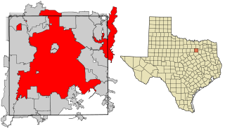
| תיאור | This map shows the incorporated areas in Dallas County, Texas. Dallas is highlighted in red. I created it in Inkscape using data from the following links: North Central Texas Council of Governments Maps Website, Dallas County Commissioner District Map (PDF) |
| תאריך יצירה | |
| מקור | My own work, based on government information. Though I strove to be as accurate in the detail as possible, the information shown is not guaranteed to be completely accurate. |
| יוצר | Ixnayonthetimmay |
| אישורים והיתרים (שימוש חוזר בקובץ זה) |
Public Domain |
| גרסאות אחרות | See Category:Maps of Dallas County, Texas for other versions of this image. |
רישיון
| ברצוני, בעלי זכויות היוצרים על יצירה זו, לשחרר יצירה זו לנחלת הכלל. זה תקף בכל העולם. יש מדינות שבהן הדבר אינו אפשרי על פי חוק, אם כך: אני מעניק לכל אחד את הזכות להשתמש בעבודה זו לכל מטרה שהיא, ללא תנאים כלשהם, אלא אם כן תנאים כאלה נדרשים על פי חוק. |
היסטוריית הקובץ
ניתן ללחוץ על תאריך/שעה כדי לראות את הקובץ כפי שנראה באותו זמן.
| תאריך/שעה | תמונה ממוזערת | ממדים | משתמש | הערה | |
|---|---|---|---|---|---|
| נוכחית | 21:27, 9 באוגוסט 2007 | | 600 × 1,050 (248 ק"ב) | Ixnayonthetimmay | == Summary == {{Information |Description=This map shows the incorporated areas in Dallas County, Texas. Dallas is highlighted in red. I created it in [[en:Inkscape|Inkscape] |
שימוש בקובץ
הדף הבא משתמש בקובץ הזה:
שימוש גלובלי בקובץ
אתרי הוויקי השונים הבאים משתמשים בקובץ זה:
- שימוש באתר als.wikipedia.org
- שימוש באתר ar.wikipedia.org
- שימוש באתר bn.wikipedia.org
- שימוש באתר br.wikipedia.org
- שימוש באתר ckb.wikipedia.org
- שימוש באתר de.wikipedia.org
- שימוש באתר en.wikipedia.org
- שימוש באתר fa.wikipedia.org
- שימוש באתר fi.wikipedia.org
- שימוש באתר fo.wikipedia.org
- שימוש באתר fr.wikipedia.org
- שימוש באתר fy.wikipedia.org
- שימוש באתר id.wikipedia.org
- שימוש באתר io.wikipedia.org
- שימוש באתר it.wikipedia.org
- שימוש באתר ja.wikipedia.org
- שימוש באתר ln.wikipedia.org
- שימוש באתר lv.wikipedia.org
- שימוש באתר ml.wikipedia.org
- שימוש באתר ms.wikipedia.org
- שימוש באתר my.wikipedia.org
- שימוש באתר nl.wikipedia.org
- שימוש באתר no.wikipedia.org
- שימוש באתר pnb.wikipedia.org
- שימוש באתר pt.wikipedia.org
- שימוש באתר qu.wikipedia.org
- שימוש באתר ro.wikipedia.org
- שימוש באתר sco.wikipedia.org
- שימוש באתר sc.wikipedia.org
- שימוש באתר sl.wikipedia.org
- שימוש באתר smn.wikipedia.org
- שימוש באתר srn.wikipedia.org
- שימוש באתר sv.wikipedia.org
- שימוש באתר ta.wikipedia.org
- שימוש באתר te.wikipedia.org
- שימוש באתר th.wikipedia.org
- שימוש באתר tl.wikipedia.org
- שימוש באתר tr.wikipedia.org
- שימוש באתר ug.wikipedia.org
- שימוש באתר ur.wikipedia.org
- שימוש באתר vi.wikipedia.org
- שימוש באתר yo.wikipedia.org