קובץ:Dampier Mosquito.gif
Dampier_Mosquito.gif (500 × 375 פיקסלים, גודל הקובץ: 14 ק"ב, סוג MIME: image/gif)
| זהו קובץ שמקורו במיזם ויקישיתוף. תיאורו בדף תיאור הקובץ המקורי (בעברית) מוצג למטה. |
| תיאור |
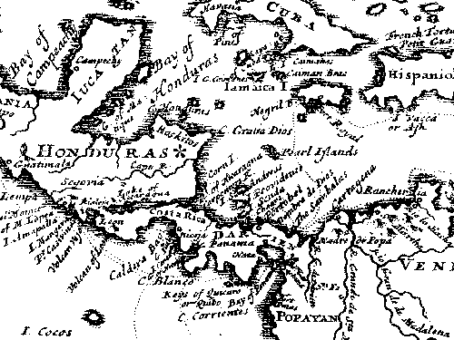
English: This map is from "A New Voyage Round the World", published in 1697 by William Dampier, the English sea captain, naturalist, and occasional pirate.
The Miskito coast is marked with a star. Dampier and his associate, the surgeon Lionel Wafer describe the Miskito peoples in the period 1690-1700. These tribal groups, often mixed with runaway slaves, formed a distinct culture in the coastal region, sometimes forming alliances with pirates against Spanish authorities in the 16th-18th centuries. |
| מקור | |
| יוצר |
רישיון
|
יצירה זו נמצאת בנחלת הכלל במדינת המקור ובמדינות אחרות בהם תקופת זכויות היוצרים היא משך חיי היוצר ו-70 שנה (או פחות) מפטירתו.
| |
| הקובץ הזה זוהה כקובץ חופשי מכל מגבלה ידועה תחת חוק זכויות היוצרים, כולל כל הזכויות הקשורות והסמוכות. | |
יומן העלאה מקורי
All following user names refer to en.wikipedia.
- 2007-06-29 02:41 Victor falk 500×375× (13914 bytes) This map is from "A New Voyage Round the World", published in 1697 by William Dampier, the English sea captain, naturalist, and occasional pirate. The Miskito coast is marked with a star. Dampier and his associate, the surgeon Lionel Wafer describe the
היסטוריית הקובץ
ניתן ללחוץ על תאריך/שעה כדי לראות את הקובץ כפי שנראה באותו זמן.
| תאריך/שעה | תמונה ממוזערת | ממדים | משתמש | הערה | |
|---|---|---|---|---|---|
| נוכחית | 12:42, 16 באוקטובר 2009 | | 375 × 500 (14 ק"ב) | Urdangaray | {{Information |Description={{en|This map is from "A New Voyage Round the World", published in 1697 by William Dampier, the English sea captain, naturalist, and occasional pirate. The Miskito coast is marked with a star. Dampier and his associate, the su |
שימוש בקובץ
הדף הבא משתמש בקובץ הזה:
שימוש גלובלי בקובץ
אתרי הוויקי השונים הבאים משתמשים בקובץ זה:
- שימוש באתר az.wikipedia.org
- שימוש באתר en.wikipedia.org
- שימוש באתר es.wikipedia.org
- שימוש באתר gl.wikipedia.org
- שימוש באתר id.wikipedia.org
- שימוש באתר tr.wikipedia.org
- שימוש באתר uk.wikipedia.org
- שימוש באתר zh.wikipedia.org