EastJerusalemMapHE1a.PNG(582 × 593 פיקסלים, גודל הקובץ: 369 ק"ב, סוג MIME‏: image/png)

ויקישיתוף זהו קובץ שמקורו במיזם ויקישיתוף. תיאורו בדף תיאור הקובץ המקורי (בעברית) מוצג למטה.

תקציר

תיאור

[עריכה]

Deutsch: Karte Jerusalems:
 
Westjerusalem und Skopusberg
 
Waffenstillstandslinie von 1949
 
Altstadt
 
Arabische Viertel in Ostjerusalem
 
Stadtgrenze bis 1967
 
Jüdische Viertel in Ostjerusalem
 
Stadtgrenze
 
Jüdische Gebiete im Westjordanland
 
Arabische Gebiete im Westjordanland
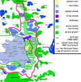
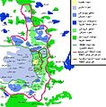
English: Map of Jerusalem:
 
West Jerusalem and Mount Scopus
 
1949 armistice line
 
Old City, fully annexed by Israel
 
East Jerusalem, occupied Arab areas, annexed by Israel
 
Pre-1967 municipal boundary
 
East Jerusalem, Jewish colonies, annexed by Israel
 
Current Israeli extended boundary of the municipality and of the district of Jerusalem
 
West Bank, Jewish colonies in the new district of Samaria and Judea (zone C)
 
West Bank, occupied Arab areas (zone A, partially controled by the Palestinian National Authority)
Español: Mapa de Jerusalén:
 
Jerusalén Oeste y Monte Scopus
 
Frontera de armisticio de 1949
 
Ciudad Vieja
 
Jerusalén Este, áreas árabes
 
Frontera anterior a 1967
 
Jerusalén Este, áreas judías
 
Frontera de Jerusalén
 
Cisjordania, áreas judías
 
Cisjordania, áreas árabes
Français : Carte de Jérusalem :
 
Jérusalem-Ouest et Mont Scopus
 
Ligne d'armistice de 1949
 
Vieille ville, entièrement annexée par Israël
 
Jérusalem-Est, secteurs arabes occupés par Israël
 
Frontière municipale avant 1967
 
Jérusalem-Est, colonies juives annexées par Israël après 1967
 
Frontière actuelle d'extension israélienne de la municipalité et du district de Jérusalem
 
Cisjordanie, colonies juives dans le nouveau district israélien de Samarie et de Judée (zone C)
 
Cisjordanie, secteurs arabes occupés (zone A, partiellement contrôlée par l'Autorité nationale palestinienne)
תאריך יצירה
מקור
image extraction process
התמונה שבקובץ זה נחתכה מקובץ אחר
 : EastJerusalemMapHE.jpg
original file
יוצר Drork, Eddau
גרסאות אחרות

[עריכה]

רישיון

w:he:Creative Commons
ייחוס שיתוף זהה
קובץ זה מופיע תחת הרישיון Creative Commons ייחוס-שיתוף זהה 3.0 לא מותאם.
הנכם רשאים:
  • לשתף – להעתיק, להפיץ ולהעביר את העבודה
  • לערבב בין עבודות – להתאים את העבודה
תחת התנאים הבאים:
  • ייחוס – יש לתת ייחוס הולם, לתת קישור לרישיון, ולציין אם נעשו שינויים. אפשר לעשות את זה בכל צורה סבירה, אבל לא בשום צורה שמשתמע ממנה שמעניק הרישיון תומך בך או בשימוש שלך.
  • שיתוף זהה – אם תיצרו רמיקס, תשנו, או תבנו על החומר, חובה עליכם להפיץ את התרומות שלך לפי תנאי רישיון זהה או תואם למקור.

כיתובים

נא להוסיף משפט שמסביר מה הקובץ מייצג

פריטים שמוצגים בקובץ הזה

מוצג

היסטוריית הקובץ

ניתן ללחוץ על תאריך/שעה כדי לראות את הקובץ כפי שנראה באותו זמן.

תאריך/שעהתמונה ממוזערתממדיםמשתמשהערה
נוכחית19:38, 30 ביולי 2009תמונה ממוזערת לגרסה מ־19:38, 30 ביולי 2009‪593 × 582‬ (369 ק"ב)Eddau~commonswiki{{Information |Description={{en|1=Map of East Jerusalem}} |Source=Modefication of the Wiki Common map EastJerusalemMapHE.jpg |Author=Drork (Modefication by Eddau) |Date=2007 May 25 (Modefication 2009 July 30) |Permission=S

הדף הבא משתמש בקובץ הזה: