קובץ:Ebensee concentration camp prisoners 1945.jpg

גודל התצוגה המקדימה הזאת: 800 × 587 פיקסלים. רזולוציות אחרות: 320 × 235 פיקסלים | 640 × 470 פיקסלים | 1,024 × 752 פיקסלים | 1,280 × 940 פיקסלים | 2,560 × 1,879 פיקסלים | 2,843 × 2,087 פיקסלים.
לקובץ המקורי (2,843 × 2,087 פיקסלים, גודל הקובץ: 926 ק"ב, סוג MIME: image/jpeg)
| זהו קובץ שמקורו במיזם ויקישיתוף. תיאורו בדף תיאור הקובץ המקורי (בעברית) מוצג למטה. |
|
◄ 1 2 3 4 5 6 7 8 9 10 11 12 13 14 15 16 17 18 19 20 21 22 23 24 25 26 ►
תקציר
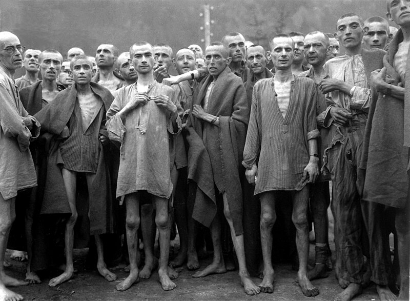
| תיאור |
English: Starved prisoners, nearly dead from hunger, pose in concentration camp in Ebensee, Austria. Ebensee was a sub-camp of the main camp 'Mauthausen' near the town of the same name. The camp was reputedly used for "scientific" experiments. It was liberated by the 80th Division of the U.S. Army.
Deutsch: Unterernährte Gefangene, fast tot vor Hunger, posieren im Konzentrationslager Ebensee, Österreich. Das Lager wurde angeblich für "wissenschaftliche" Experimente verwendet. Es wurde von der 80. Division der U.S. Army befreit. |
|||
| תאריך יצירה | צולם ב- 7 במאי 1945 | |||
| מקור |
|
|||
| יוצר | Lt. Arnold E. Samuelson | |||
| אישורים והיתרים (שימוש חוזר בקובץ זה) |
National Archives FAQ | |||
| גרסאות אחרות |
.jpg)
| מיקום המצלמה | | תמונה זו ותמונות נוספות במיקום: OpenStreetMap |
|---|
רישיון
This file is a work of a U.S. Army soldier or employee, taken or made as part of that person's official duties. As a work of the U.S. federal government, it is in the public domain in the United States.
|
 |
היסטוריית הקובץ
ניתן ללחוץ על תאריך/שעה כדי לראות את הקובץ כפי שנראה באותו זמן.
| תאריך/שעה | תמונה ממוזערת | ממדים | משתמש | הערה | |
|---|---|---|---|---|---|
| נוכחית | 03:18, 30 בדצמבר 2006 | | 2,087 × 2,843 (926 ק"ב) | Wikifreund | {{:Tour:Nazi final solution}} {{Information |Description=Starved prisoners, nearly dead from hunger, pose in concentration camp in Ebensee, Austria. The camp was reputedly used for "scientific" experiments. It was liberated by the 80th Division. May 7, 1 |
| 00:43, 28 במאי 2006 |  | 440 × 600 (74 ק"ב) | Jkelly | {{Information |Description= Starved prisoners, nearly dead from hunger, pose in concentration camp in Ebensee, Austria. The camp was reputedly used for "scientific" experiments. It was liberated by the 80th Division. |Source= [http://arcweb.archives.gov/a |
שימוש בקובץ
הדפים הבאים משתמשים בקובץ הזה:
שימוש גלובלי בקובץ
אתרי הוויקי השונים הבאים משתמשים בקובץ זה:
- שימוש באתר af.wikipedia.org
- שימוש באתר ar.wikipedia.org
- שימוש באתר az.wikipedia.org
- שימוש באתר bg.wikipedia.org
- שימוש באתר bn.wikipedia.org
- שימוש באתר bo.wikipedia.org
- שימוש באתר ca.wikipedia.org
- שימוש באתר ceb.wikipedia.org
- שימוש באתר cs.wikipedia.org
- שימוש באתר da.wikipedia.org
- שימוש באתר de.wikipedia.org
- שימוש באתר el.wikipedia.org
- שימוש באתר en.wikipedia.org
- List of subcamps of Mauthausen
- 80th Division (United States)
- Joaquim Amat-Piniella
- Wikipedia:Today's featured article/July 2006
- Wikipedia:Today's featured article/July 9, 2006
- Ebensee concentration camp
- Identification of inmates in Nazi concentration camps
- Wikipedia:Featured pictures thumbs/08
- Arnold E. Samuelson
- Wikipedia:Featured picture candidates/Survivors of Mauthausen concentration camp
- Wikipedia:Featured picture candidates/October-2007
- Wikipedia:Wikipedia Signpost/2007-10-08/Features and admins
- Wikipedia:Picture of the day/February 2008
- Template:POTD/2008-02-03
- Wikipedia:Featured pictures/History/World War II
- Wikipedia:Wikipedia Signpost/2007-10-08/SPV
- Talk:World War II/Infobox/Archive 2
- Comparison of Nazism and Stalinism
- User:OnBeyondZebrax/sandbox/The Holocaust
- Moshe Ha-Elion
- Wikipedia:WikiProject Military history/Featured content
- Portal:History/Recognized content
- Wikipedia:Wikipedia Signpost/Single/2007-10-08
- שימוש באתר eo.wikipedia.org
- שימוש באתר es.wikipedia.org
- שימוש באתר et.wikipedia.org
- שימוש באתר fi.wikipedia.org
- שימוש באתר fi.wikinews.org