קובץ:Europe 1848 map en.png

גודל התצוגה המקדימה הזאת: 800 × 526 פיקסלים. רזולוציות אחרות: 320 × 211 פיקסלים | 640 × 421 פיקסלים | 1,024 × 674 פיקסלים | 1,280 × 842 פיקסלים | 2,284 × 1,503 פיקסלים.
לקובץ המקורי (2,284 × 1,503 פיקסלים, גודל הקובץ: 1.22 מ"ב, סוג MIME: image/png)
| זהו קובץ שמקורו במיזם ויקישיתוף. תיאורו בדף תיאור הקובץ המקורי (בעברית) מוצג למטה. |
תקציר
| תיאור |
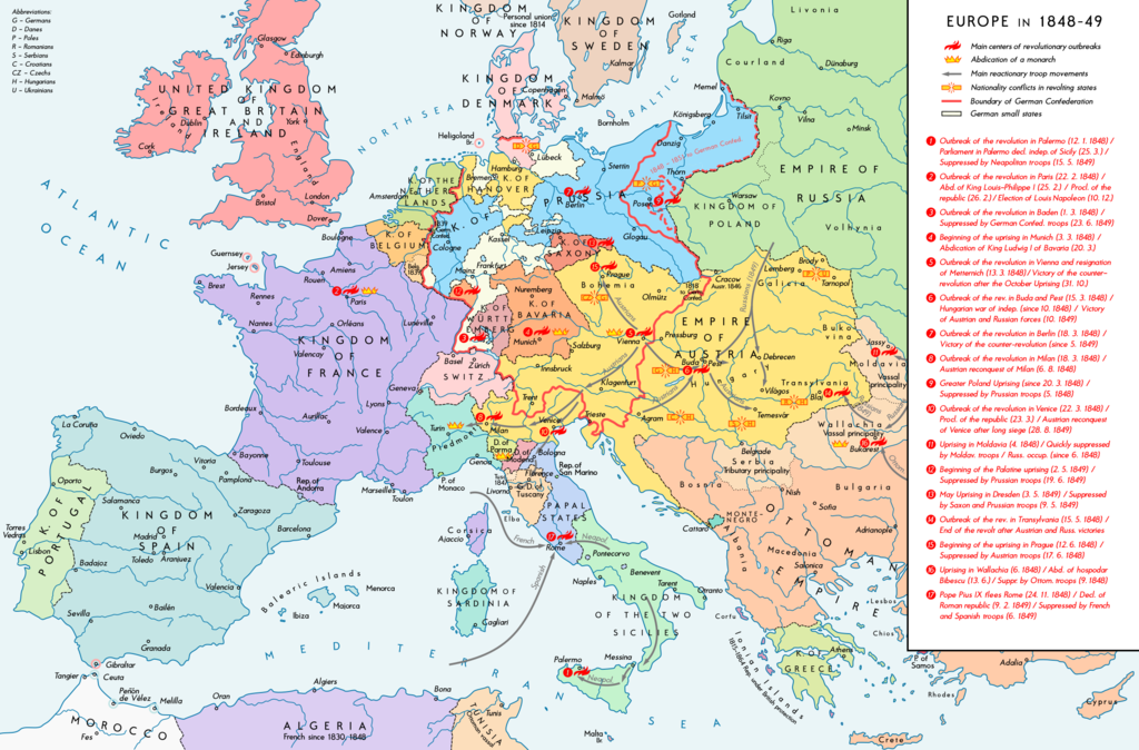
English: Europe 1848-49. Historical map with main revolutionary centres, important reactionary troop movements, states with abdications and national conflicts. Please don't alter the map, when you think there something not written or depicted correctly. Leave a message at the talk page of the file. After a verification and a possible discussion, i will upload a new map version with all new changes. This prevents an unnecessary waste of disc space and ensures a good result, aesthetically and contentwise. - The author. Deutsch: Europa 1848/49. Historische Karte mit wichtigen revolutionären Orten, Hauptschlagrichtungen konterrevolutionärer Truppen, Staaten mit Abdankungen von Monarchen und Nationalitätenkonflikten. Bitte die Karte bei Änderungs- und Korrekturwünschen nicht selbst verändern, sondern eine Anmerkung im Diskussionsbereich der Bilddatei hinterlassen. Nach einer Prüfung und ggfs. Diskussion werden evtl. Änderungen von mir zusammengefasst eingearbeitet. Das vermeidet unnötige Speicherplatz-Verschwendung und gewährleistet ein ästhetisch ansprechendes und inhaltlich korrektes Ergebnis. - Der Urheber. |
| תאריך יצירה | |
| מקור |
נוצר על־ידי מעלה היצירה. Source of Information: Historical atlases – Ramsay Muir, George Philip (ed.): Philip's New School Atlas of Universal History, George Philip & Son, Ltd., London 1928 – Dr. Walter Leisering (ed.): Putzger Historischer Weltatlas, Cornelsen Verlag, Berlin 1992, ISBN 3-464-00176-8 – Bayerischer Schulbuch-Verlag (ed.): Großer Historischer Weltatlas, Dritter Teil, Neuzeit, Bayerischer Schulbuch-Verlag, München 1981, ISBN 3-7627-6021-7 – Prof. Dr. Vadim Oswalt u. Prof. Dr. Hans Ulrich Rudolf (ed.): Klett-Perthes Atlas zur Weltgeschichte, Ernst Klett Verlag, Stuttgart 2011, ISBN 978-3-12-828194-0 – Zentralinstitut für Geschichte der Akademie der Wissenschaften der DDR (ed.): Atlas zur Geschichte, Band 1, VEB Hermann Haack, Gotha 1989, ISBN 3-7301-0040-8 – Domokos György (ed.): Történelmi atlasz a középiskolák számára, Kartográfiai Vállalat. Budapest, Budapest 1989, ISBN 963-351-422-3 Other publications – Mike Rapport: 1848. Revolution in Europa, Wissenschaftliche Buchgesellschaft, Lizenzausgabe des Konrad Theiss Verlags, 2011, ISBN 978-3-534-23963-4 |
| יוצר | Alexander Altenhof |
| גרסאות אחרות |
|


Recompressed without quality loss with OptiPNG (1.51 MB > 1.20 MB)
רישיון
אני, בעל זכויות היוצרים על עבודה זו, מפרסם בזאת את העבודה תחת הרישיון הבא:
הקובץ הזה מתפרסם לפי תנאי רישיון קריאייטיב קומונז ייחוס-שיתוף זהה 4.0 בין־לאומי.
- הנכם רשאים:
- לשתף – להעתיק, להפיץ ולהעביר את העבודה
- לערבב בין עבודות – להתאים את העבודה
- תחת התנאים הבאים:
- ייחוס – יש לתת ייחוס הולם, לתת קישור לרישיון, ולציין אם נעשו שינויים. אפשר לעשות את זה בכל צורה סבירה, אבל לא בשום צורה שמשתמע ממנה שמעניק הרישיון תומך בך או בשימוש שלך.
- שיתוף זהה – אם תיצרו רמיקס, תשנו, או תבנו על החומר, חובה עליכם להפיץ את התרומות שלך לפי תנאי רישיון זהה או תואם למקור.
היסטוריית הקובץ
ניתן ללחוץ על תאריך/שעה כדי לראות את הקובץ כפי שנראה באותו זמן.
| תאריך/שעה | תמונה ממוזערת | ממדים | משתמש | הערה | |
|---|---|---|---|---|---|
| נוכחית | 02:38, 15 באפריל 2017 | | 1,503 × 2,284 (1.22 מ"ב) | KaterBegemot | Minor changes |
| 01:50, 12 בספטמבר 2016 |  | 1,503 × 2,284 (1.21 מ"ב) | KaterBegemot | Changed border of Serbia | |
| 01:34, 12 בספטמבר 2016 |  | 1,503 × 2,284 (1.21 מ"ב) | KaterBegemot | Changed color of Greece, corrected border at Tarnopol, minor text corrections | |
| 18:17, 29 באוגוסט 2016 |  | 1,503 × 2,284 (1.21 מ"ב) | KaterBegemot | {{Information |Description ={{en|1=Europe 1848-49. Historical map with main revolutionary centres, important reactionary troop movements, states with abdications and national conflicts.<br> ''Please don't alter the map, when you think there somethin... |
שימוש בקובץ
הדף הבא משתמש בקובץ הזה:
שימוש גלובלי בקובץ
אתרי הוויקי השונים הבאים משתמשים בקובץ זה:
- שימוש באתר ar.wikipedia.org
- שימוש באתר ast.wikipedia.org
- שימוש באתר az.wikipedia.org
- שימוש באתר el.wikipedia.org
- שימוש באתר en.wikipedia.org
- שימוש באתר hr.wikipedia.org
- שימוש באתר hu.wikipedia.org
- שימוש באתר it.wikipedia.org
- שימוש באתר ja.wikipedia.org
- שימוש באתר ka.wikipedia.org
- שימוש באתר km.wikipedia.org
- שימוש באתר lt.wikipedia.org
- שימוש באתר mk.wikipedia.org
- שימוש באתר pnb.wikipedia.org
- שימוש באתר ru.wikipedia.org
- שימוש באתר sq.wikipedia.org
- שימוש באתר uk.wikipedia.org
- שימוש באתר ur.wikipedia.org
- שימוש באתר vi.wikipedia.org