קובץ:Famine en URSS 1933.jpg
לקובץ המקורי (649 × 905 פיקסלים, גודל הקובץ: 610 ק"ב, סוג MIME: image/jpeg)
| זהו קובץ שמקורו במיזם ויקישיתוף. תיאורו בדף תיאור הקובץ המקורי (בעברית) מוצג למטה. |
תקציר
| תיאור |
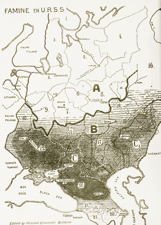
English: Famine in USSR, 1933. Areas of most disastrous famine marked with black.
Explanation of symbols on the map: A - grain-consuming regions, B - grain-producing regions. C - former land of Don, Kuban and Terek cossacks, C1 - former land of Ural and Orenburg cossacks. 1. Kola Peninsula, 2. Northern region, 3. Karelia, 4. Komi, 5. Leningrad Oblast, 6. Ivanovo Oblast, 7. Moscow Oblast, 8. Nizhny Novgorod region, 9. Western Oblast. 10. Byelorussia, 11. Central Black Earth Region, 12. Ukraine, 13. Central Volga region, 14. Tataria, 15. Bashkiria, 16. Ural region, 17. Lower Volga region, 18. North Caucasus Krai, 19. Georgia, 20. Azerbaijan, 21. Armenia.Русский: Объяснение обозначений на карте: A - районы потребляющей полосы, B - районы производящей полосы. C - бывшая территория донских, кубанских и терских казаков, C1 - бывшая территория уральских и оренбургских казаков.
1. Кольский полуостров, 2. Северный край, 3. Карелия, 4. Область Коми, 5. Ленинградская (Петербургская) область, 6. Ивановская промышленная область, 7. Московская область, 8. Нижегородский край, 9. Западная область. 10. Белоруссия, 11. Центрально-Чернозёмная область, 12. Украина, 13. Средне-Волжский край, 14. Татария, 15. Башкирия, 16. Уральская область, 17. Нижневолжский край, 18. Северо-Кавказский край, 19. Грузия, 20. Азербайджан, 21. Армения. |
||||
| תאריך יצירה | |||||
| מקור |
1. A. Markoff "Famine in USSR" [1] 2. приложение к N 4-5 эмигрантского журнала "За рулем", август-сентябрь 1933 года. Перепечатка из Русского экономического бюллетеня, 9. [2] |
||||
| יוצר | неизв. | ||||
| אישורים והיתרים (שימוש חוזר בקובץ זה) |
|
||||
| גרסאות אחרות |
|
||||


היסטוריית הקובץ
ניתן ללחוץ על תאריך/שעה כדי לראות את הקובץ כפי שנראה באותו זמן.
| תאריך/שעה | תמונה ממוזערת | ממדים | משתמש | הערה | |
|---|---|---|---|---|---|
| נוכחית | 14:19, 2 במרץ 2014 | | 905 × 649 (610 ק"ב) | Soerfm | Color, contrast |
| 12:17, 16 ביולי 2010 |  | 905 × 649 (193 ק"ב) | DonaldDuck | {{Information |Description=Карта главных районов голода в СССР. Чем гуще штриховка - тем сильнее размеры бедствия. Объяснение обозначений на карте:A - ра |
שימוש בקובץ
הדפים הבאים משתמשים בקובץ הזה:
שימוש גלובלי בקובץ
אתרי הוויקי השונים הבאים משתמשים בקובץ זה:
- שימוש באתר az.wikipedia.org
- שימוש באתר ba.wikipedia.org
- שימוש באתר be-tarask.wikipedia.org
- שימוש באתר bg.wikipedia.org
- שימוש באתר cs.wikipedia.org
- שימוש באתר de.wikipedia.org
- שימוש באתר en.wikipedia.org
- History of Russia
- Joseph Stalin
- Soviet Union
- Collectivization in the Soviet Union
- Holodomor
- Droughts and famines in Russia and the Soviet Union
- Soviet famine of 1930–1933
- Portal:Genocide/Selected article
- Portal:Genocide/Selected article/2
- Mass killings under communist regimes
- Portal:Soviet Union
- Collective farming
- Excess mortality in the Soviet Union under Joseph Stalin
- User:Adamdead/sandbox
- Abraham Markoff
- User:BlueSwurl/sandbox
- User:Pawelboch/sandbox
- User:Vivaelcelta/Mass killings under communist regimes
- שימוש באתר en.wikiversity.org
- שימוש באתר es.wikipedia.org
- שימוש באתר et.wikipedia.org
- שימוש באתר eu.wikipedia.org
- שימוש באתר fa.wikipedia.org
- שימוש באתר fr.wikipedia.org
- שימוש באתר fy.wikipedia.org
- שימוש באתר id.wikipedia.org