קובץ:Frankish kingdoms in 628.jpg

לקובץ המקורי (1,239 × 1,149 פיקסלים, גודל הקובץ: 355 ק"ב, סוג MIME: image/jpeg)
| זהו קובץ שמקורו במיזם ויקישיתוף. תיאורו בדף תיאור הקובץ המקורי (בעברית) מוצג למטה. |
תקציר
| תיאור |
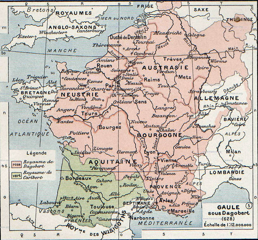
English: The map comes from Vidal-Lablache, Atlas général d'histoire et de géographie (1894). It shows the Frankish kingdoms in 628 AD.
Français : Gaule sous Dagobert (628). Paul Vidal de La Blache, Atlas général d'histoire et de géographie (1894). |
||||||||||||||||||||
| תאריך יצירה | |||||||||||||||||||||
| מקור | Paul Vidal de La Blache, Atlas général d'histoire et de géographie (1894). | ||||||||||||||||||||
| יוצר |
|
||||||||||||||||||||

רישיון
This image is in the public domain because it is a mere mechanical scan or photocopy of a public domain original, or – from the available evidence – is so similar to such a scan or photocopy that no copyright protection can be expected to arise. The original itself is in the public domain for the following reason:
This tag is designed for use where there may be a need to assert that any enhancements (eg brightness, contrast, colour-matching, sharpening) are in themselves insufficiently creative to generate a new copyright. It can be used where it is unknown whether any enhancements have been made, as well as when the enhancements are clear but insufficient. For known raw unenhanced scans you can use an appropriate {{PD-old}} tag instead. For usage, see Commons:When to use the PD-scan tag.  | ||||
יומן העלאה מקורי
- 2007-08-19 21:37 Srnec 1239×1149×8 (363198 bytes) The map comes from Vidal-Lablache, ''Atlas général d'histoire et de géographie'' (1894). {{PD-art-life-70}}
היסטוריית הקובץ
ניתן ללחוץ על תאריך/שעה כדי לראות את הקובץ כפי שנראה באותו זמן.
| תאריך/שעה | תמונה ממוזערת | ממדים | משתמש | הערה | |
|---|---|---|---|---|---|
| נוכחית | 23:19, 26 בנובמבר 2007 | | 1,149 × 1,239 (355 ק"ב) | Obersachse | {{Information |Description={{en|The map comes from Vidal-Lablache, ''Atlas général d'histoire et de géographie'' (1894).}} |Source=Transfered from [http://en.wikipedia.org en.wikipedia] |Date=2007-08-19 (original upload date) |Author=Original uploader |
שימוש בקובץ
הדף הבא משתמש בקובץ הזה:
שימוש גלובלי בקובץ
אתרי הוויקי השונים הבאים משתמשים בקובץ זה:
- שימוש באתר af.wikipedia.org
- שימוש באתר als.wikipedia.org
- שימוש באתר arz.wikipedia.org
- שימוש באתר azb.wikipedia.org
- שימוש באתר be.wikipedia.org
- שימוש באתר bg.wikipedia.org
- שימוש באתר br.wikipedia.org
- שימוש באתר ca.wikipedia.org
- שימוש באתר de.wikipedia.org
- שימוש באתר el.wikipedia.org
- שימוש באתר en.wikipedia.org
- שימוש באתר eo.wikipedia.org
- שימוש באתר es.wikipedia.org
- שימוש באתר eu.wikipedia.org
- שימוש באתר fr.wikipedia.org
- שימוש באתר gl.wikipedia.org
- שימוש באתר hy.wikipedia.org
- שימוש באתר id.wikipedia.org
- שימוש באתר it.wikipedia.org
- שימוש באתר ko.wikipedia.org
- שימוש באתר nl.wikipedia.org
- שימוש באתר pt.wikipedia.org