קובץ:GulaMons SifMons northeast.jpg

גודל התצוגה המקדימה הזאת: 750 × 600 פיקסלים. רזולוציות אחרות: 300 × 240 פיקסלים | 600 × 480 פיקסלים | 960 × 768 פיקסלים | 1,280 × 1,024 פיקסלים | 2,560 × 2,048 פיקסלים | 5,000 × 4,000 פיקסלים.
לקובץ המקורי (5,000 × 4,000 פיקסלים, גודל הקובץ: 1.87 מ"ב, סוג MIME: image/jpeg)
| זהו קובץ שמקורו במיזם ויקישיתוף. תיאורו בדף תיאור הקובץ המקורי (בעברית) מוצג למטה. |
תקציר
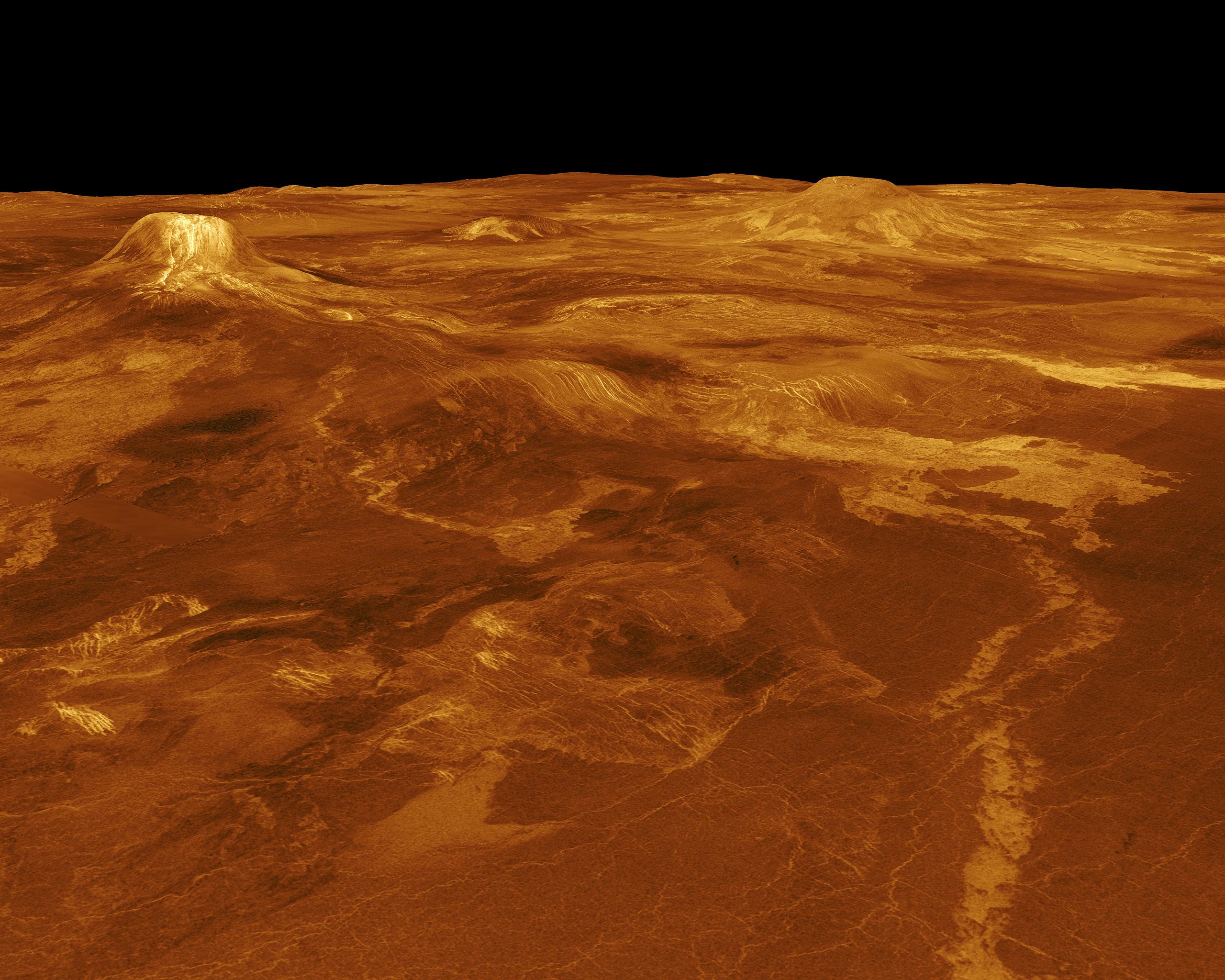
| תיאור | A portion of western Eistla Regio is displayed in this three-dimensional perspective view of the surface of Venus. The viewpoint is located 1,100 kilometers (682 miles) northeast of Gula Mons at an elevation of 7.5 kilometers (4.6 miles). Lava flows extend for hundreds of kilometers across the fractured plains shown in the foreground to the base of Gula Mons. The viewpoint is to the southwest with Gula Mons appearing at the left just below the horizon. Gula Mons, a 3 kilometers (1.8 miles) high volcano, is located at approximately 22 degrees north latitude, 359 degrees east longitude. Sif Mons, a volcano with a diameter of 300 kilometers (180 miles) and a height of 2 kilometers (1.2 miles), appears to the right of Gula Mons. The distance between Sif Mons and Gula Mons is approximately 730 kilometers (453 miles). Magellan synthetic aperture radar data is combined with radar altimetry to develop a three-dimensional map of the surface. Ray tracing (rays as if from a light source are cast in a computer to intersect the surface) simulate a perspective view. Simulated color and a digital elevation map developed by Randy Kirk of the U.S. Geological Survey, are used to enhance small scale structure. The simulated hues are based on color images recorded by the Soviet Venera 13 and 14 spacecraft. The image was produced at the JPL Multimission Image Processing Laboratory by Eric De Jong, Jeff Hall and Myche McAuley, and is a single frame from a video released at a March 5, 1991, JPL news conference. |
| מקור | http://photojournal.jpl.nasa.gov/catalog/PIA00102 |
| יוצר | JPL/NASA |
This image or video was catalogued by Jet Propulsion Laboratory of the United States National Aeronautics and Space Administration (NASA) under Photo ID: PIA00102. This tag does not indicate the copyright status of the attached work. A normal copyright tag is still required. See Commons:Licensing. Other languages:
|
רישיון
| קובץ זה נמצא ברשות הציבור מכיוון שהוא נוצר על ידי נאס"א. מדיניות זכויות היוצרים של נאס"א קובעת ש"חומרים של NASA אינם מוגנים בזכויות יוצרים אלא אם צוין אחרת". (דף מדיניות זכויות היוצרים ב-NASA או מדיניות שימוש בתמונות ב-JPL). | ||
 |
אזהרות:
|
היסטוריית הקובץ
ניתן ללחוץ על תאריך/שעה כדי לראות את הקובץ כפי שנראה באותו זמן.
| תאריך/שעה | תמונה ממוזערת | ממדים | משתמש | הערה | |
|---|---|---|---|---|---|
| נוכחית | 00:40, 26 בנובמבר 2007 | | 4,000 × 5,000 (1.87 מ"ב) | Lotse | {{Information |Description=A portion of western Eistla Regio is displayed in this three-dimensional perspective view of the surface of Venus. The viewpoint is located 1,100 kilometers (682 miles) northeast of Gula Mons at an elevation of 7.5 kilometers (4 |
שימוש בקובץ
הדף הבא משתמש בקובץ הזה:
שימוש גלובלי בקובץ
אתרי הוויקי השונים הבאים משתמשים בקובץ זה:
- שימוש באתר en.wikipedia.org
- שימוש באתר zh.wikipedia.org