קובץ:Dennis 2005-07-07 1550Z.jpg

לקובץ המקורי (5,600 × 7,200 פיקסלים, גודל הקובץ: 3.42 מ"ב, סוג MIME: image/jpeg)
| זהו קובץ שמקורו במיזם ויקישיתוף. תיאורו בדף תיאור הקובץ המקורי (בעברית) מוצג למטה. |
תקציר
| תיאור |
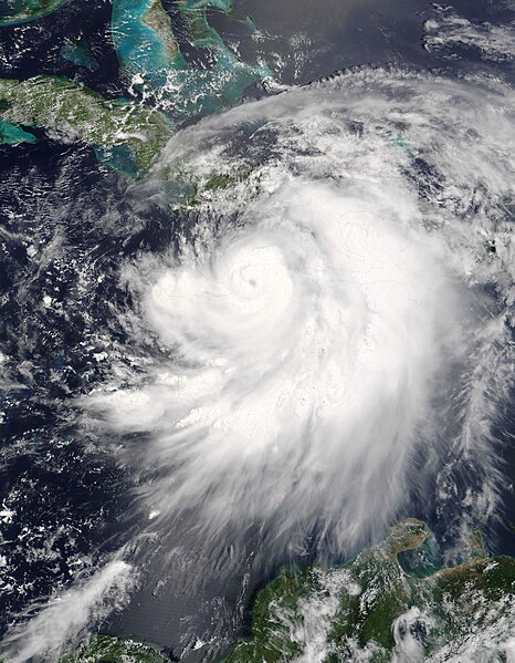
English: Hurricane Dennis threaded its way between Jamaica and Haiti on a direct course for Cuba on July 7, 2005. The storm now has the distinctive hurricane form, with a well-defined eye surrounded by bands of swirling clouds. At 10:50 a.m. local time (15:50 UTC), when the Moderate Resolution Imaging Spectroradiometer (MODIS) on NASA's Terra satellite took this image, Dennis was just below a Category 3 hurricane, with winds of 175 kilometers per hour (110 miles per hour) and stronger gusts. Less than an hour before this image was taken, the storm's small dark eye was about 105 kilometers (65 miles) northeast of Kingston, Jamaica, and 170 kilometers (105 miles) south-southeast of Guantanamo, Cuba. The National Hurricane Center reports that Dennis is traveling northwest at about 24 kilometers per hour (15 mph). A storm of this size is a threat not just because of its powerful winds: Dennis is expected to produce heavy rain and coastal and inland flooding. Five to ten inches of rain may fall over Haiti, the Dominican Republic, Jamaica, Cuba, and the Cayman Islands, with as much as 15 inches falling in parts of Jamaica. Heavy rainfall can trigger flash floods and mudslides in mountainous regions. The storm will probably also raise tide levels by five to seven feet and generate large and dangerous waves. Français : l'Ouragan Dennis trace sa voie entre la Jamaïque et Haiti et se dirige vers Cuba le 7 juillet 2005. La dépression a maintenant toutes les caractéristiques d'un cyclone, et en particulier un œuil bien défini. Au moment ou la photo a été prise, l'ouragan allait atteindre le niveau 3, avec des vents de 175 km/h. Une heure avant que la photo ne soit prise, l'œuil du cyclone était à mi-chemin entre Kingston, en Jamaïque et Guantanamo, à Cuba. Les cyclones présentent une grande menace dans la zone caraibe non seulement à cause des vents violents, des grandes vagues qu'ils provoquent et des ondes de tempête; mais aussi des pluies diluviennes qui s'abbattent sur leur sillage (plus de 350 mm pour Dennis), et qui entrainent des crues brutales et des coulées de boue. |
|||||
| תאריך יצירה | ||||||
| מקור | http://earthobservatory.nasa.gov/NaturalHazards/natural_hazards_v2.php3?img_id=12941 | |||||
| יוצר | NASA image courtesy Jeff Schmaltz, MODIS Land Rapid Response Team at NASA GSFC | |||||
| אישורים והיתרים (שימוש חוזר בקובץ זה) |
|

הערכה
|
תמונה זו נבחרה כתמונת היום בתאריך 11 באוגוסט 2005. כותרתה: English: Hurricane Dennis on July 7 2005 שפות אחרות:
Brezhoneg : Skeudenn dre loarell ar gorventenn Dennis d'ar 7 a viz Gouere 2005 Čeština: Hurikán Dennis 7. července 2005. Cymraeg: Gorwynt Dennis, 7 Gorffennaf 2005. Dansk: Satellitbillede af orkanen Dennis den 7. juli 2005. Deutsch: Satellitenbild des Hurrikans Dennis am 7. Juli 2005 English: Hurricane Dennis on July 7 2005 Español: Huracán Dennis el 7 de julio del 2005. Français : Image satellite de l'ouragan Dennis, le 7 juillet 2005 Latina: Dionysius furacanum, 7. Iulii 2005 Nederlands: Orkaan Dennis op 7 Juli 2005 Norsk bokmål: Satelittbilde av orkanen Dennis den 7. juli 2005. Norsk nynorsk: Satelittbilde av orkanen Dennis den 7. juli 2005. Polski: Huragan Dennis, 7 lipca 2005 Português: Furacão Dennis a 7 de Julho, 2005 Slovenčina: Hurikán Dennis 7. júla 2005. Slovenščina: Satelitski posnetek hurikana Dennis, 7. julija 2005 Suomi: Hurrikaani Dennis 7.7.2005 Svenska: Satellitbild av orkanen Dennis den 7 juli 2005 Русский: Спутниковый снимок урагана Дэннис, 7 июля 2005 日本語: ハリケーン「デニス」 2005年7月7日 中文: 2005年7月7日的飓风丹尼斯卫星照片 |
היסטוריית הקובץ
ניתן ללחוץ על תאריך/שעה כדי לראות את הקובץ כפי שנראה באותו זמן.
| תאריך/שעה | תמונה ממוזערת | ממדים | משתמש | הערה | |
|---|---|---|---|---|---|
| נוכחית | 03:32, 9 ביולי 2005 | | 7,200 × 5,600 (3.42 מ"ב) | Tom | shaving off a few MB |
| 03:26, 9 ביולי 2005 |  | 7,200 × 5,600 (5.33 מ"ב) | Tom | {{PD-USGov}} http://earthobservatory.nasa.gov/Newsroom/NewImages/Images/Dennis_TMO_2005188_lrg.jpg |
שימוש בקובץ
הדף הבא משתמש בקובץ הזה:
שימוש גלובלי בקובץ
אתרי הוויקי השונים הבאים משתמשים בקובץ זה:
- שימוש באתר af.wikipedia.org
- שימוש באתר ba.wikipedia.org
- שימוש באתר bg.wikipedia.org
- שימוש באתר de.wikipedia.org
- שימוש באתר de.wiktionary.org
- שימוש באתר en.wikipedia.org
- Portal:Caribbean
- Portal:Tropical cyclones/Featured article/Hurricane Dennis
- Wikipedia:Today's featured article/February 2006
- Wikipedia:Today's featured article/February 6, 2006
- Portal:Tropical cyclones/Anniversaries/July
- Portal:Tropical cyclones/Anniversaries/July/8
- Portal:Geography/Featured picture archive/2005
- Portal:Jamaica
- List of the wettest tropical cyclones by country
- User:Daniel Mietchen/Science communication gallery
- Effects of Hurricane Dennis in Jamaica
- Effects of Hurricane Dennis in Haiti
- Template:Did you know nominations/Effects of Hurricane Dennis in Haiti
- User:LeToadman/sandbox
- User:RedLambda/UBX
- User:RedLambda/UBX/Meteorology
- שימוש באתר en.wiktionary.org
- שימוש באתר fi.wikipedia.org
- שימוש באתר fr.wikipedia.org
- שימוש באתר ia.wikipedia.org
- שימוש באתר ko.wikipedia.org
- שימוש באתר ku.wikipedia.org
- שימוש באתר li.wiktionary.org
- שימוש באתר nn.wikipedia.org
- שימוש באתר no.wikipedia.org
- שימוש באתר pl.wikipedia.org
- שימוש באתר pl.wiktionary.org
- שימוש באתר pt.wikipedia.org
- שימוש באתר ru.wikipedia.org
- שימוש באתר sk.wikipedia.org
- שימוש באתר sq.wikipedia.org
- שימוש באתר su.wikipedia.org
- שימוש באתר sv.wikipedia.org