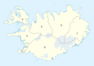
קובץ:Iceland, administrative divisions - Nmbrs.svg

גודל התצוגה המקדימה הזאת מסוג PNG של קובץ ה־SVG הזה: 800 × 567 פיקסלים. רזולוציות אחרות: 320 × 227 פיקסלים | 640 × 454 פיקסלים | 1,024 × 726 פיקסלים | 1,280 × 908 פיקסלים | 2,560 × 1,815 פיקסלים | 1,186 × 841 פיקסלים.
לקובץ המקורי (קובץ SVG, הגודל המקורי: 1,186 × 841 פיקסלים, גודל הקובץ: 233 ק"ב)
| זהו קובץ שמקורו במיזם ויקישיתוף. תיאורו בדף תיאור הקובץ המקורי (בעברית) מוצג למטה. |
תקציר


.svg)


_(Paris_zoom).svg)
.svg)
,_administrative_divisions_-_de_-_colored_(multizoom).svg)
_-_colored.svg)
.svg)
,_administrative_divisions_-_Nmbrs_(multizoom).svg)
,_administrative_divisions_-_de_-_colored.svg)
_-_de_-_colored.svg)

.svg)

.svg)
רישיון
אני, בעל זכויות היוצרים על היצירה הזאת, מפרסם אותה בזאת תחת הרישיונות הבאים:
הקובץ הזה מתפרסם לפי תנאי רישיון קריאייטיב קומונז ייחוס-שיתוף זהה 3.0 לא מותאם.
- הנכם רשאים:
- לשתף – להעתיק, להפיץ ולהעביר את העבודה
- לערבב בין עבודות – להתאים את העבודה
- תחת התנאים הבאים:
- ייחוס – יש לתת ייחוס הולם, לתת קישור לרישיון, ולציין אם נעשו שינויים. אפשר לעשות את זה בכל צורה סבירה, אבל לא בשום צורה שמשתמע ממנה שמעניק הרישיון תומך בך או בשימוש שלך.
- שיתוף זהה – אם תיצרו רמיקס, תשנו, או תבנו על החומר, חובה עליכם להפיץ את התרומות שלך לפי תנאי רישיון זהה או תואם למקור.

|
מוענקת בכך הרשות להעתיק, להפיץ או לשנות את המסמך הזה, לפי תנאי הרישיון לשימוש חופשי במסמכים של גנו, גרסה 1.2 או כל גרסה מאוחרת יותר שתפורסם על־ידי המוסד לתוכנה חופשית; ללא פרקים קבועים, ללא טקסט עטיפה קדמית וללא טקסט עטיפה אחורית. עותק של הרישיון כלול בפרק שכותרתו הרישיון לשימוש חופשי במסמכים של גנו. |
הנכם מוזמנים לבחור את הרישיון הרצוי בעיניכם.

|
I'd greatly appreciate, that you attribute this media file to Wikimedia Commons, if used outside Wikipedia or Commons. For use in publications such as books, newspapers, blogs, websites, please insert here the following line:
|
היסטוריית הקובץ
ניתן ללחוץ על תאריך/שעה כדי לראות את הקובץ כפי שנראה באותו זמן.
| תאריך/שעה | תמונה ממוזערת | ממדים | משתמש | הערה | |
|---|---|---|---|---|---|
| נוכחית | 09:21, 10 ביוני 2021 | | 841 × 1,186 (233 ק"ב) | Bjarki S | Hornafjörður transferred from eastern to southern region |
| 03:26, 20 בנובמבר 2018 |  | 841 × 1,186 (232 ק"ב) | A Red Cherry | Added labels/compass and legend, as requested | |
| 20:44, 19 בנובמבר 2018 |  | 841 × 1,186 (226 ק"ב) | A Red Cherry | Somebody can be added the numbers, later. What's more important is to ensure that the map is correct; the prior information you have added is simply wrong. | |
| 19:46, 19 בנובמבר 2018 |  | 841 × 1,186 (318 ק"ב) | NordNordWest | Reverted to version as of 11:40, 15 June 2012 (UTC) where are the numbers? | |
| 06:21, 19 בנובמבר 2018 |  | 841 × 1,186 (226 ק"ב) | A Red Cherry | Many border shifts; updated to a newer SVG locator map | |
| 14:40, 15 ביוני 2012 |  | 841 × 1,186 (318 ק"ב) | TUBS |
שימוש בקובץ
הדף הבא משתמש בקובץ הזה:
שימוש גלובלי בקובץ
אתרי הוויקי השונים הבאים משתמשים בקובץ זה:
- שימוש באתר af.wikipedia.org
- שימוש באתר an.wikipedia.org
- שימוש באתר en.wikipedia.org
- שימוש באתר frr.wikipedia.org
- שימוש באתר hu.wikipedia.org
- שימוש באתר id.wikipedia.org
- שימוש באתר is.wikipedia.org
- שימוש באתר li.wikipedia.org
- שימוש באתר ru.wikipedia.org
- שימוש באתר zh.wikipedia.org