קובץ:LA2-Europe-UTM-zones.png

גודל התצוגה המקדימה הזאת: 553 × 599 פיקסלים. רזולוציות אחרות: 221 × 240 פיקסלים | 443 × 480 פיקסלים | 960 × 1,040 פיקסלים.
לקובץ המקורי (960 × 1,040 פיקסלים, גודל הקובץ: 219 ק"ב, סוג MIME: image/png)
| זהו קובץ שמקורו במיזם ויקישיתוף. תיאורו בדף תיאור הקובץ המקורי (בעברית) מוצג למטה. |
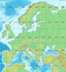
Map of Europe, showing the latitude and longitude zones of the en:Universal Transverse Mercator coordinate system, from 29S to 38W.
Bounding box West -12°, South 32°, East 48°, North 72°. Center at 52°00′N 18°00′E / 52.00°N 18.00°E.
This image is in the public domain because it came from the site https://www.demis.nl/products/web-map-server/examples/ and was released by the copyright holder. Permission is granted to copy, distribute and/or modify this map since it is based on free of copyright images from: www.demis.nl. See also approval email on de.wp and its clarification.
|
| This work has been released into the public domain by its copyright holder, www.demis.nl. This applies worldwide. יש מדינות שבהן הדבר אינו אפשרי על פי חוק, אם כך: www.demis.nl מעניק לכל אחד את הזכות להשתמש ביצירה הזאת לכל מטרה, ללא שום תנאי, אלא אם כן תנאים כאלה נדרשים לפי החוק.
|
היסטוריית הקובץ
ניתן ללחוץ על תאריך/שעה כדי לראות את הקובץ כפי שנראה באותו זמן.
| תאריך/שעה | תמונה ממוזערת | ממדים | משתמש | הערה | |
|---|---|---|---|---|---|
| נוכחית | 02:10, 2 בספטמבר 2006 | | 1,040 × 960 (219 ק"ב) | LA2 | Map of Europe, showing the latitude and longitude zones of the en:Universal Transverse Mercator coordinate system, from 29S to 38W. Bounding box West -12°, South 32°, East 49°, North 72°. Center at {{coor d|52.00000|N|18.50000|E|scale:24000000}} |
שימוש בקובץ
הדף הבא משתמש בקובץ הזה:
שימוש גלובלי בקובץ
אתרי הוויקי השונים הבאים משתמשים בקובץ זה:
- שימוש באתר ar.wikipedia.org
- שימוש באתר ca.wikipedia.org
- שימוש באתר da.wikipedia.org
- שימוש באתר de.wikipedia.org
- שימוש באתר en.wikipedia.org
- שימוש באתר es.wikipedia.org
- שימוש באתר fa.wikipedia.org
- שימוש באתר fi.wikipedia.org
- שימוש באתר fr.wikipedia.org
- שימוש באתר gl.wikipedia.org
- שימוש באתר hu.wikipedia.org
- שימוש באתר ja.wikipedia.org
- שימוש באתר nl.wikipedia.org
- שימוש באתר no.wikipedia.org
- שימוש באתר pl.wikipedia.org
- שימוש באתר pt.wikipedia.org
- שימוש באתר sr.wikipedia.org
- שימוש באתר sv.wikipedia.org
- שימוש באתר th.wikipedia.org