קובץ:Map indicating Hudson Strait, Nunavut, Canada.png
אין גרסה ברזולוציה גבוהה יותר.
Map_indicating_Hudson_Strait,_Nunavut,_Canada.png (410 × 370 פיקסלים, גודל הקובץ: 52 ק"ב, סוג MIME: image/png)
| זהו קובץ שמקורו במיזם ויקישיתוף. תיאורו בדף תיאור הקובץ המקורי (בעברית) מוצג למטה. |
תקציר
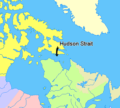
Map indicating Hudson Strait, Nunavut, Canada.
Nunavut
Greenland
Quebec
Newfoundland and Labrador
Manitoba
Ontario
© Her Majesty the Queen in Right of Canada, Department of Natural Resources. All rights reserved.
Licence Agreement
רישיון

|
The copyright holder of this work allows anyone to use it for any purpose including unrestricted redistribution, commercial use, and modification.
Usage notes:
|
היסטוריית הקובץ
ניתן ללחוץ על תאריך/שעה כדי לראות את הקובץ כפי שנראה באותו זמן.
| תאריך/שעה | תמונה ממוזערת | ממדים | משתמש | הערה | |
|---|---|---|---|---|---|
| נוכחית | 16:55, 21 במרץ 2006 | | 370 × 410 (52 ק"ב) | David Kernow~commonswiki | == Summary == Map indicating Hudson Strait, Nunavut, Canada. {{legend|#ffff66|Nunavut}} {{legend|#ffffcc|Greenland}} {{legend|#d5fe94|Quebec}} {{legend|#ecebb6|Newfoundland and Labrador}} {{legend|#ccccff|Manitoba}} {{legend|#ffcccc|O |
שימוש בקובץ
הדף הבא משתמש בקובץ הזה:
שימוש גלובלי בקובץ
אתרי הוויקי השונים הבאים משתמשים בקובץ זה:
- שימוש באתר ar.wikipedia.org
- שימוש באתר az.wikipedia.org
- שימוש באתר ba.wikipedia.org
- שימוש באתר bg.wikipedia.org
- שימוש באתר bn.wikipedia.org
- שימוש באתר ca.wikipedia.org
- שימוש באתר cs.wikipedia.org
- שימוש באתר da.wikipedia.org
- שימוש באתר de.wikipedia.org
- שימוש באתר en.wikipedia.org
- שימוש באתר eo.wikipedia.org
- שימוש באתר eu.wikipedia.org
- שימוש באתר fa.wikipedia.org
- שימוש באתר fi.wikipedia.org
- שימוש באתר fr.wikipedia.org
- שימוש באתר gl.wikipedia.org
- שימוש באתר hr.wikipedia.org
- שימוש באתר id.wikipedia.org
- שימוש באתר it.wikipedia.org
- שימוש באתר ka.wikipedia.org
- שימוש באתר la.wikipedia.org
- שימוש באתר li.wikipedia.org
- שימוש באתר lt.wikipedia.org
- שימוש באתר mhr.wikipedia.org
- שימוש באתר ml.wikipedia.org
- שימוש באתר nl.wikipedia.org
- שימוש באתר nn.wikipedia.org
- שימוש באתר no.wikipedia.org
- שימוש באתר pl.wikipedia.org
- שימוש באתר pt.wikipedia.org
- שימוש באתר ru.wikipedia.org
- שימוש באתר simple.wikipedia.org
- שימוש באתר sk.wikipedia.org
- שימוש באתר sl.wikipedia.org
- שימוש באתר sr.wikipedia.org
- שימוש באתר sv.wikipedia.org
- שימוש באתר sw.wikipedia.org
- שימוש באתר uz.wikipedia.org
- שימוש באתר vi.wikipedia.org
- שימוש באתר war.wikipedia.org