קובץ:Map of Central Asia with trade routes and movements, von Richthofen.png
גודל התצוגה המקדימה הזאת: 800 × 483 פיקסלים. רזולוציות אחרות: 320 × 193 פיקסלים | 640 × 386 פיקסלים | 1,024 × 618 פיקסלים | 1,280 × 772 פיקסלים | 2,034 × 1,227 פיקסלים.
לקובץ המקורי (2,034 × 1,227 פיקסלים, גודל הקובץ: 4.8 מ"ב, סוג MIME: image/png)
| זהו קובץ שמקורו במיזם ויקישיתוף. תיאורו בדף תיאור הקובץ המקורי (בעברית) מוצג למטה. |
תקציר
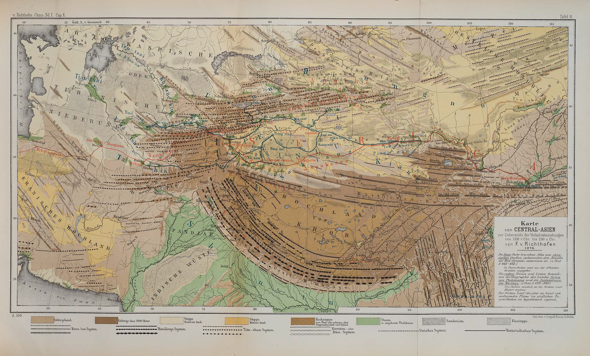
| תיאור | Map of Central Asia for overview of trade routes and movements from 128 BC to 150 AD |
| תאריך יצירה |
Dated 1876 Published 1877 |
| מקור |
F. von Richthofen (1877). China: Ergebnisse eigener Reisen und darauf gegründeter Studien. Band 1, Einleitender Theil [China: Expedition results and studies based thereupon. Volume 1, Introductory Part]. Berlin: Verlag von Dietrich Reimer. As reproduced in James D. Sidaway & Chih Yuan Woon (2017). Chinese Narratives on “One Belt, One Road” (一带一路) in Geopolitical and Imperial Contexts. The Professional Geographer 69(4), 591-603. doi: 10.1080/00330124.2017.1288576 |
| יוצר | F. von Richthofen (1833–1905) |
| גרסאות אחרות |
.png)
רישיון
|
יצירה זו נמצאת בנחלת הכלל במדינת המקור ובמדינות אחרות בהם תקופת זכויות היוצרים היא משך חיי היוצר ו-100 שנה (או פחות) מפטירתו.
| |
| הקובץ הזה זוהה כקובץ חופשי מכל מגבלה ידועה תחת חוק זכויות היוצרים, כולל כל הזכויות הקשורות והסמוכות. | |
| Annotations | This image is annotated: View the annotations at Commons |
היסטוריית הקובץ
ניתן ללחוץ על תאריך/שעה כדי לראות את הקובץ כפי שנראה באותו זמן.
| תאריך/שעה | תמונה ממוזערת | ממדים | משתמש | הערה | |
|---|---|---|---|---|---|
| נוכחית | 11:14, 24 בנובמבר 2018 | | 1,227 × 2,034 (4.8 מ"ב) | Cold Season | {{Information |Description= Map of Central Asia for overview of trade routes and movements. |Source= Von Richthofen, F. (1877). ''China: Ergebnisse eigener Reisen und darauf gegründeter Studien''. Band 1, Einleitender Theil [China: Expedition results and studies based thereupon. Volume 1, Introductory Part]. Berlin: Verlag von Dietrich Reimer. As reproduced in James D. Sidaway & Chih Yuan Woon (2017) Chinese Narratives on “One Belt, One Road” (一带一路) in Geopolitical and Imperial Contexts, ''T... |
שימוש בקובץ
הדף הבא משתמש בקובץ הזה:
שימוש גלובלי בקובץ
אתרי הוויקי השונים הבאים משתמשים בקובץ זה:
- שימוש באתר en.wikipedia.org
- שימוש באתר et.wikipedia.org
- שימוש באתר fa.wikipedia.org
- שימוש באתר ko.wikipedia.org
- שימוש באתר pt.wikipedia.org
- שימוש באתר sl.wikipedia.org
- שימוש באתר th.wikipedia.org