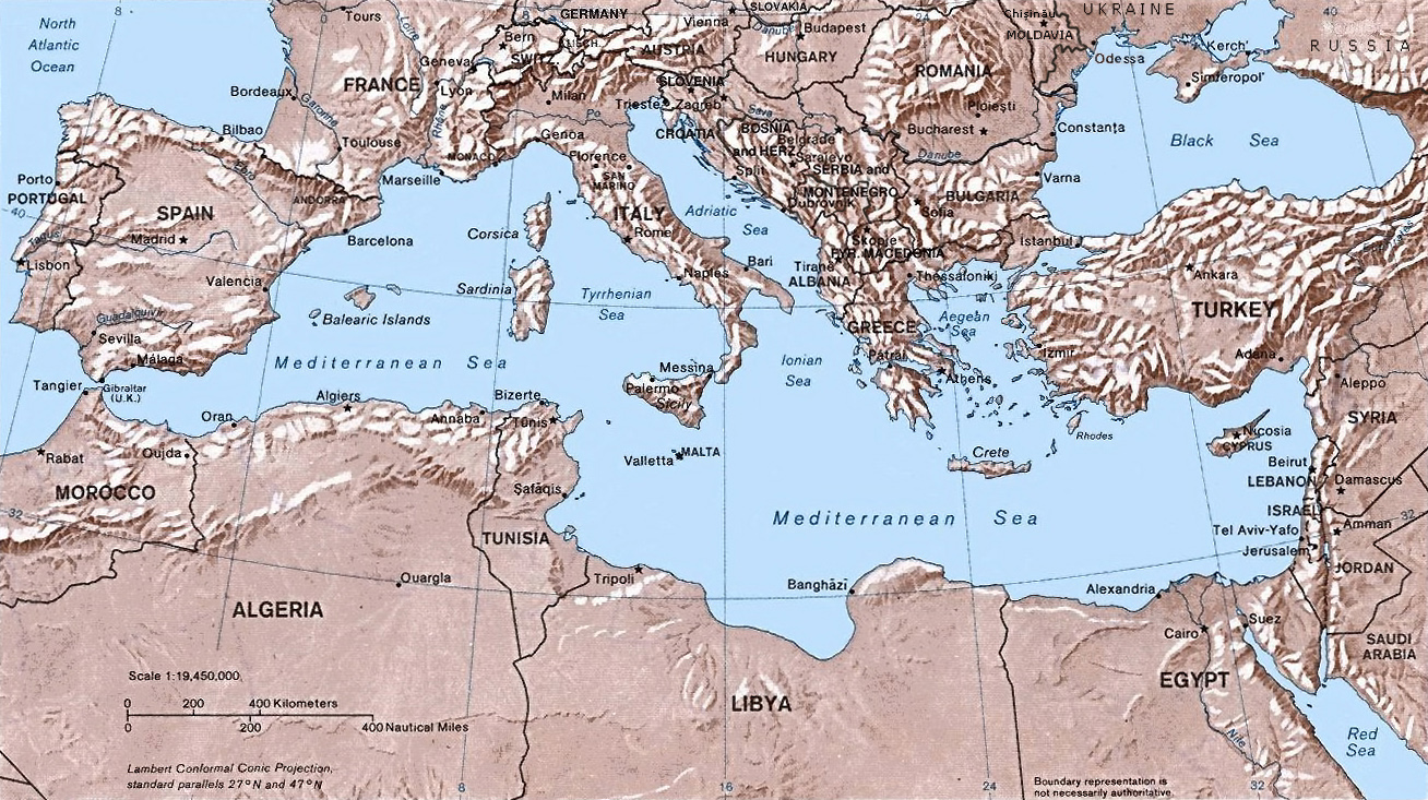
קובץ:Mediterranean Relief.jpg
גודל התצוגה המקדימה הזאת: 800 × 448 פיקסלים. רזולוציות אחרות: 320 × 179 פיקסלים | 640 × 359 פיקסלים | 1,308 × 733 פיקסלים.
לקובץ המקורי (1,308 × 733 פיקסלים, גודל הקובץ: 635 ק"ב, סוג MIME: image/jpeg)
| זהו קובץ שמקורו במיזם ויקישיתוף. תיאורו בדף תיאור הקובץ המקורי (בעברית) מוצג למטה. |

|
יש ליצור מחדש את התמונה map הזו באמצעות גרפיקה וקטורית כדוגמת קובץ SVG. לפעולה זו מספר יתרונות, כפי שניתן לקרוא (באנגלית) בדף Commons:Media for cleanup. אם ברשותכם קובץ SVG, אנא העלו אותו. לאחר מכן, החליפו תבנית זו בתבנית
{{vector version available|שם הקובץ.svg}} |


- Shaded relief Map of the Mediterranean Sea - and its Basin and Landforms.
- The original map was created in 1982 by the Central Intelligence Agency ([1], specifically [2]).
- This version was produced by w:User:Joy, who originally uploaded it to the English Wikipedia:
- 23:46, 28 Sep 2004 . . Joy (343433 bytes) (an update after 22 years :) added borders and names for the ex-yu republics (si,hr,ba,cs,mk); corrected names for de,sk; dropped su name but didn't bother drawing the md/uk/ru borders or names because they're not near the topic at hand, and it's tiresome)
![[2]](http://www.lib.utexas.edu/maps/europe/mediterranean_rel82.jpg)
This work is in the public domain in the United States because it is a work prepared by an officer or employee of the United States Government as part of that person’s official duties under the terms of Title 17, Chapter 1, Section 105 of the US Code.
Note: This only applies to original works of the Federal Government and not to the work of any individual U.S. state, territory, commonwealth, county, municipality, or any other subdivision. This template also does not apply to postage stamp designs published by the United States Postal Service since 1978. (See § 313.6(C)(1) of Compendium of U.S. Copyright Office Practices). It also does not apply to certain US coins; see The US Mint Terms of Use.
|
 | |
| הקובץ הזה זוהה כקובץ חופשי מכל מגבלה ידועה תחת חוק זכויות היוצרים, כולל כל הזכויות הקשורות והסמוכות. | ||
היסטוריית הקובץ
ניתן ללחוץ על תאריך/שעה כדי לראות את הקובץ כפי שנראה באותו זמן.
| תאריך/שעה | תמונה ממוזערת | ממדים | משתמש | הערה | |
|---|---|---|---|---|---|
| נוכחית | 17:32, 6 במאי 2016 | | 733 × 1,308 (635 ק"ב) | Julieta39 | Actualised the borders |
| 00:38, 31 במאי 2015 |  | 733 × 1,308 (614 ק"ב) | Subtropical-man | Reverted to version as of 18:25, 29 August 2011 | |
| 03:59, 1 בספטמבר 2011 |  | 800 × 1,428 (400 ק"ב) | Gwillhickers | Larger image, better sharpness | |
| 03:58, 1 בספטמבר 2011 |  | 800 × 1,428 (400 ק"ב) | Gwillhickers | Larger ima | |
| 21:25, 29 באוגוסט 2011 |  | 733 × 1,308 (614 ק"ב) | Subtropical-man | ||
| 01:21, 25 באוגוסט 2011 |  | 800 × 1,428 (400 ק"ב) | Gwillhickers | better sharpness, color tone | |
| 04:01, 27 ביוני 2010 |  | 733 × 1,308 (614 ק"ב) | Ras67 | rotated and cropped | |
| 23:22, 4 ביוני 2010 |  | 739 × 1,325 (288 ק"ב) | Cropbot | upload cropped version, operated by User:diaa_abdelmoneim. Summary: cropped | |
| 22:22, 21 בדצמבר 2005 |  | 792 × 1,332 (274 ק"ב) | Lhgodoy~commonswiki | Noise removal in original image | |
| 23:59, 4 בדצמבר 2004 |  | 792 × 1,332 (335 ק"ב) | Alfio | Map of the Mediterranean Sea |
שימוש בקובץ
הדפים הבאים משתמשים בקובץ הזה:
שימוש גלובלי בקובץ
אתרי הוויקי השונים הבאים משתמשים בקובץ זה:
- שימוש באתר af.wikipedia.org
- שימוש באתר am.wikipedia.org
- שימוש באתר arc.wikipedia.org
- שימוש באתר ar.wikipedia.org
- שימוש באתר arz.wikipedia.org
- שימוש באתר ast.wikipedia.org
- שימוש באתר as.wikipedia.org
- שימוש באתר az.wikipedia.org
- שימוש באתר az.wiktionary.org
- שימוש באתר be.wikipedia.org
- שימוש באתר bo.wikipedia.org
- שימוש באתר bs.wikipedia.org
- שימוש באתר ca.wikipedia.org
- שימוש באתר ceb.wikipedia.org
- שימוש באתר cv.wikipedia.org
- שימוש באתר cy.wikipedia.org
- שימוש באתר da.wikipedia.org
- שימוש באתר de.wikipedia.org
- שימוש באתר dsb.wikipedia.org
- שימוש באתר dty.wikipedia.org
- שימוש באתר el.wikipedia.org
- שימוש באתר en.wikipedia.org
- שימוש באתר en.wiktionary.org
- שימוש באתר eo.wikipedia.org
- שימוש באתר es.wikipedia.org