קובץ:Moyen Orient 13e siècle.svg

לקובץ המקורי(קובץ SVG, הגודל המקורי: 1,885 × 1,354 פיקסלים, גודל הקובץ: 4.03 מ"ב)

הצגת תמונה זו בשפה .
ויקישיתוף זהו קובץ שמקורו במיזם ויקישיתוף. תיאורו בדף תיאור הקובץ המקורי (בעברית) מוצג למטה.
Translate this file
SVG עושה שימוש בטקסט שניתן לתרגם בקלות לשפתך. לפרטים נוספים.

עבור תמונות SVG, ניתן להשתמש ב[toolforge:svgtranslate/File:Moyen_Orient_13e_si%C3%A8cle.svglink כלי עזר] כדי לתרגם את התמונה לשפתך.

 
. Inkscape עם‎‎ נוצרה ה תמונה
תיאור
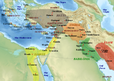
Català: Mapa que mostra l'extensió aproximada dels principals regnes de l'Orient Mitjà durant el segle XIII aC, amb les principals ciutats i jaciments arqueològics, i algunes regions.
English: Map showing the approximate extension of the main kingdoms of the Middle East durint the 13th century BCE, with the main cities and archaeological sites, and some regions.
Français : Carte montrant l'extension approximative des principaux royaumes du Moyen-Orient au XIIIe siècle av. J.-C., avec la localisation des villes et sites archéologiques principaux, ainsi que de certaines régions.
תאריך יצירה (UTC)
מקור
יוצר
גרסאות אחרות
Other related versions: [עריכה]
Derivative works of this file:  Moyen Orient 13e siècle.png
Translate this file
SVG עושה שימוש בטקסט שניתן לתרגם בקלות לשפתך. לפרטים נוספים.

עבור תמונות SVG, ניתן להשתמש ב[toolforge:svgtranslate/File:Moyen_Orient_13e_si%C3%A8cle.svglink כלי עזר] כדי לתרגם את התמונה לשפתך.

This file is translated using SVG <switch> elements. All translations are stored in the same file! Learn more.

For most Wikipedia projects, you can embed the file normally (without a lang parameter). The Wikipedia will use its language if the SVG file supports that language. For example, the German Wikipedia will use German if the SVG file has German. To embed this file in a particular language use the lang parameter with the appropriate language code, e.g. [[File:Moyen Orient 13e siècle.svg|lang=en]] for the English version. Do not specify a lang parameter if it is not needed. The parameter may prevent the use of a subsequent translation.

To translate the text into your language, you can use the SVG Translate tool. Alternatively, you can download the file to your computer, add your translations using whatever software you're familiar with, and re-upload it with the same name. You will find help in Graphics Lab if you're not sure how to do this.

זוהי תמונה מרוטשת, זאת אומרת שהתמונה שונתה בצורה דיגיטלית מהמקור. Modifications: Ajout des royaumes, sites archéologiques et régions.. את התמונה המקורית ניתן לראות ב: Middle East topographic map-blank.svg. השינוי בוצע על ידי Zunkir.

אני, בעל זכויות היוצרים על היצירה הזאת, מפרסם אותה בזאת תחת הרישיונות הבאים:
w:he:Creative Commons
ייחוס שיתוף זהה
הקובץ הזה מתפרסם לפי תנאי רישיונות קריאייטיב קומונז ייחוס-שיתוף זהה 3.0 לא מותאם, 2.5 כללי, 2.0 כללי ו־1.0 כללי.
הנכם רשאים:
  • לשתף – להעתיק, להפיץ ולהעביר את העבודה
  • לערבב בין עבודות – להתאים את העבודה
תחת התנאים הבאים:
  • ייחוס – יש לתת ייחוס הולם, לתת קישור לרישיון, ולציין אם נעשו שינויים. אפשר לעשות את זה בכל צורה סבירה, אבל לא בשום צורה שמשתמע ממנה שמעניק הרישיון תומך בך או בשימוש שלך.
  • שיתוף זהה – אם תיצרו רמיקס, תשנו, או תבנו על החומר, חובה עליכם להפיץ את התרומות שלך לפי תנאי רישיון זהה או תואם למקור.
GNU head מוענקת בכך הרשות להעתיק, להפיץ או לשנות את המסמך הזה, לפי תנאי הרישיון לשימוש חופשי במסמכים של גנו, גרסה 1.2 או כל גרסה מאוחרת יותר שתפורסם על־ידי המוסד לתוכנה חופשית; ללא פרקים קבועים, ללא טקסט עטיפה קדמית וללא טקסט עטיפה אחורית. עותק של הרישיון כלול בפרק שכותרתו הרישיון לשימוש חופשי במסמכים של גנו.
הנכם מוזמנים לבחור את הרישיון הרצוי בעיניכם.

יומן העלאה מקורי

This image is a derivative work of the following images:

  • File:Middle_East_topographic_map-blank.svg licensed with Cc-by-sa-3.0,2.5,2.0,1.0, GFDL
    • 2010-11-03T17:52:56Z Sémhur 3097x1938 (10510751 Bytes) == {{int:filedesc}} == {{Information |Description={{Multilingual description |en= Blank physical map of the [[:en:Middle East|Middle East]] |fr= Carte physique vierge du [[:fr:Moyen-Orient|Moyen-Orient]]. }} |Source={{own}}.

Uploaded with derivativeFX

כיתובים

נא להוסיף משפט שמסביר מה הקובץ מייצג
Approximate extended display map of major kingdoms in the Middle East in the 13th century BC. AD, with the location of the main cities and archaeological sites, as well as certain regions.

פריטים שמוצגים בקובץ הזה

מוצג

image/svg+xml

היסטוריית הקובץ

ניתן ללחוץ על תאריך/שעה כדי לראות את הקובץ כפי שנראה באותו זמן.

תאריך/שעהתמונה ממוזערתממדיםמשתמשהערה
נוכחית19:02, 22 בפברואר 2024תמונה ממוזערת לגרסה מ־19:02, 22 בפברואר 2024‪1,354 × 1,885‬ (4.03 מ"ב)ManlleusFile uploaded using svgtranslate tool (https://svgtranslate.toolforge.org/). Added translation for ca.
18:36, 22 בפברואר 2024תמונה ממוזערת לגרסה מ־18:36, 22 בפברואר 2024‪1,354 × 1,885‬ (3.97 מ"ב)Manlleusfixed text labels for translation
23:29, 28 באוקטובר 2011תמונה ממוזערת לגרסה מ־23:29, 28 באוקטובר 2011‪1,354 × 1,885‬ (3.97 מ"ב)ZunkirPolice et remaniements mineurs.
13:15, 14 ביולי 2011תמונה ממוזערת לגרסה מ־13:15, 14 ביולי 2011‪1,354 × 1,885‬ (3.97 מ"ב)ZunkirAjout du pays de Lukka.
14:01, 14 בנובמבר 2010תמונה ממוזערת לגרסה מ־14:01, 14 בנובמבר 2010‪1,354 × 1,885‬ (3.97 מ"ב)Zunkir{{Information |Description={{Multilingual description |fr= Carte montrant l'extension approximative des principaux royaumes du Moyen-Orient au XIIIe siècle av. J.-C., avec la localisation des villes et sites archéologiques principaux, ainsi que de certa

הדף הבא משתמש בקובץ הזה:

שימוש גלובלי בקובץ

מטא־נתונים