קובץ:NPS theodore-roosevelt-regional-map.jpg

אין גרסה ברזולוציה גבוהה יותר.
NPS_theodore-roosevelt-regional-map.jpg (550 × 394 פיקסלים, גודל הקובץ: 142 ק"ב, סוג MIME: image/jpeg)
| זהו קובץ שמקורו במיזם ויקישיתוף. תיאורו בדף תיאור הקובץ המקורי (בעברית) מוצג למטה. |
תקציר
| תיאור |
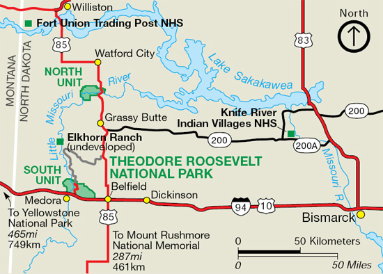
English: Regional map of Theodore Roosevelt National Park, showing its location in reference to I-94, other major roads, other national park sites, and towns in this area of western North Dakota. |
| תאריך יצירה | |
| מקור | U.S. National Park Service (http://npmaps.com/wp-content/uploads/theodore-roosevelt-regional-map.jpg) |
| יוצר | U.S. National Park Service, restoration/cleanup by Matt Holly |
רישיון
| This image or media file contains material based on a work of a National Park Service employee, created as part of that person's official duties. As a work of the U.S. federal government, such work is in the public domain in the United States. See the NPS website and NPS copyright policy for more information. |
היסטוריית הקובץ
ניתן ללחוץ על תאריך/שעה כדי לראות את הקובץ כפי שנראה באותו זמן.
| תאריך/שעה | תמונה ממוזערת | ממדים | משתמש | הערה | |
|---|---|---|---|---|---|
| נוכחית | 12:43, 17 במאי 2017 | | 394 × 550 (142 ק"ב) | RKBot | =={{int:filedesc}}== {{Information |description= {{en|1=Regional map of Theodore Roosevelt National Park, showing its location in reference to I-94, other major roads, other national park sites, and towns in this area of western North Dakota.}} |date=... |
שימוש בקובץ
הדף הבא משתמש בקובץ הזה:
שימוש גלובלי בקובץ
אתרי הוויקי השונים הבאים משתמשים בקובץ זה:
- שימוש באתר de.wikipedia.org
- שימוש באתר it.wikipedia.org