קובץ:Nordkapp map.png
גודל התצוגה המקדימה הזאת: 800 × 509 פיקסלים. רזולוציות אחרות: 320 × 204 פיקסלים | 640 × 408 פיקסלים | 837 × 533 פיקסלים.
לקובץ המקורי (837 × 533 פיקסלים, גודל הקובץ: 400 ק"ב, סוג MIME: image/png)
| זהו קובץ שמקורו במיזם ויקישיתוף. תיאורו בדף תיאור הקובץ המקורי (בעברית) מוצג למטה. |
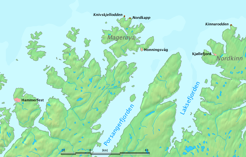
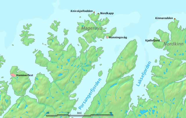
Map of North Cape region, Norway.
The map shows Nordkapp, Kinnarodden (northernmost point of mainland Europe, located on Nordkinn peninsula) and Knivskjellodden (northernmost point of Europe, located on the island of Magerøya).
Work by Markus Bernet, background map courtesy of www.demis.nl[dead link].
This image is in the public domain because it came from the site https://www.demis.nl/products/web-map-server/examples/ and was released by the copyright holder. Permission is granted to copy, distribute and/or modify this map since it is based on free of copyright images from: www.demis.nl. See also approval email on de.wp and its clarification.
|
| This work has been released into the public domain by its copyright holder, www.demis.nl. This applies worldwide. יש מדינות שבהן הדבר אינו אפשרי על פי חוק, אם כך: www.demis.nl מעניק לכל אחד את הזכות להשתמש ביצירה הזאת לכל מטרה, ללא שום תנאי, אלא אם כן תנאים כאלה נדרשים לפי החוק.
|
היסטוריית הקובץ
ניתן ללחוץ על תאריך/שעה כדי לראות את הקובץ כפי שנראה באותו זמן.
| תאריך/שעה | תמונה ממוזערת | ממדים | משתמש | הערה | |
|---|---|---|---|---|---|
| נוכחית | 14:45, 26 במרץ 2006 | | 533 × 837 (400 ק"ב) | MRB | Map of North Cape region, Norway. The map shows '''Nordkapp''', '''Kinnarodden''' (northernmost point of ''mainland'' Europe, located on Nordkinn peninsula) and '''Knivskjellodden''' (northernmost point of Europe, located on the island of Magerøya). W |
שימוש בקובץ
הדף הבא משתמש בקובץ הזה:
שימוש גלובלי בקובץ
אתרי הוויקי השונים הבאים משתמשים בקובץ זה:
- שימוש באתר az.wikipedia.org
- שימוש באתר bg.wikipedia.org
- שימוש באתר cy.wikipedia.org
- שימוש באתר da.wikipedia.org
- שימוש באתר de.wikipedia.org
- שימוש באתר de.wiktionary.org
- שימוש באתר el.wikipedia.org
- שימוש באתר en.wikipedia.org
- שימוש באתר es.wikipedia.org
- שימוש באתר et.wikipedia.org
- שימוש באתר fa.wikipedia.org
- שימוש באתר fi.wikipedia.org
- שימוש באתר fr.wikipedia.org
- שימוש באתר fy.wikipedia.org
- שימוש באתר gl.wikipedia.org
- שימוש באתר hr.wikipedia.org
- שימוש באתר hu.wikipedia.org
- שימוש באתר it.wikipedia.org
- שימוש באתר kw.wikipedia.org
- שימוש באתר nl.wikipedia.org