קובץ:Old baton rouge.jpg

גודל התצוגה המקדימה הזאת: 750 × 600 פיקסלים. רזולוציות אחרות: 300 × 240 פיקסלים | 600 × 480 פיקסלים | 960 × 768 פיקסלים | 1,280 × 1,024 פיקסלים | 1,440 × 1,152 פיקסלים.
לקובץ המקורי (1,440 × 1,152 פיקסלים, גודל הקובץ: 193 ק"ב, סוג MIME: image/jpeg)
| זהו קובץ שמקורו במיזם ויקישיתוף. תיאורו בדף תיאור הקובץ המקורי (בעברית) מוצג למטה. |
תקציר
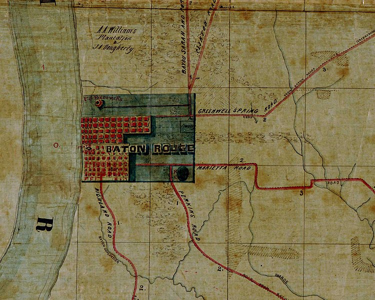
Map of old Baton Rouge. Detail from "Map of the region east and north of Baton Rouge, showing batteries on the Mississippi north of Port Hudson". According to the Library of Congress catalog entry, the creation date of the map is "1863?"; that is, this date is probable but not certain.
Original work
http://hdl.loc.gov/loc.gmd/g4014b.cw1007000
רישיון
This work is in the public domain in the United States because it is a work prepared by an officer or employee of the United States Government as part of that person’s official duties under the terms of Title 17, Chapter 1, Section 105 of the US Code.
Note: This only applies to original works of the Federal Government and not to the work of any individual U.S. state, territory, commonwealth, county, municipality, or any other subdivision. This template also does not apply to postage stamp designs published by the United States Postal Service since 1978. (See § 313.6(C)(1) of Compendium of U.S. Copyright Office Practices). It also does not apply to certain US coins; see The US Mint Terms of Use.
|
 | |
| הקובץ הזה זוהה כקובץ חופשי מכל מגבלה ידועה תחת חוק זכויות היוצרים, כולל כל הזכויות הקשורות והסמוכות. | ||

|
map זה זמין במחלקת {{{division_name}}} תחת מספר מזהה: g4014b.cw1007000. תבנית זו אינה מעידה על מצב זכויות היוצרים של היצירה. לתבנית זו יש לצרף תבנית רישיון מתאימה.
|
היסטוריית הקובץ
ניתן ללחוץ על תאריך/שעה כדי לראות את הקובץ כפי שנראה באותו זמן.
| תאריך/שעה | תמונה ממוזערת | ממדים | משתמש | הערה | |
|---|---|---|---|---|---|
| נוכחית | 05:32, 16 באוגוסט 2007 | | 1,152 × 1,440 (193 ק"ב) | Kkmurray | Map of old Baton Rouge. Detail from "Map of the region east and north of Baton Rouge, showing batteries on the Mississippi north of Port Hudson". ==Original work== http://hdl.loc.gov/loc.gmd/g4014b.cw1007000 [Map of the region east and north of Baton |
שימוש בקובץ
הדף הבא משתמש בקובץ הזה:
שימוש גלובלי בקובץ
אתרי הוויקי השונים הבאים משתמשים בקובץ זה:
- שימוש באתר en.wikipedia.org
- שימוש באתר it.wikipedia.org