קובץ:Orbits around earth scale diagram.svg

גודל התצוגה המקדימה הזאת מסוג PNG של קובץ ה־SVG הזה: 600 × 600 פיקסלים. רזולוציות אחרות: 240 × 240 פיקסלים | 480 × 480 פיקסלים | 768 × 768 פיקסלים | 1,024 × 1,024 פיקסלים | 2,048 × 2,048 פיקסלים | 4,300 × 4,300 פיקסלים.
לקובץ המקורי (קובץ SVG, הגודל המקורי: 4,300 × 4,300 פיקסלים, גודל הקובץ: 5 ק"ב)
| זהו קובץ שמקורו במיזם ויקישיתוף. תיאורו בדף תיאור הקובץ המקורי (בעברית) מוצג למטה. |
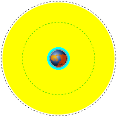
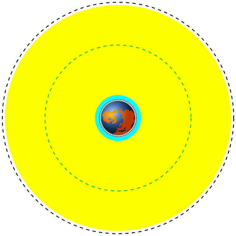
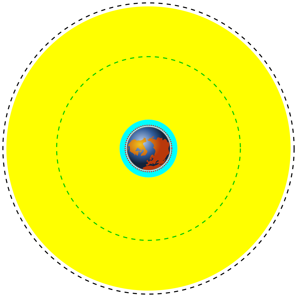
| English | Deutsch | Français | Marker | Distance above earth (km) | Distance from center of earth (km) |
|---|---|---|---|---|---|
| Earth | Erde | Terre | Blue/brown image | 0 | 6370 |
| Low Earth Orbit (LEO) | Low Earth Orbit | Orbite terrestre basse | Cyan area | 160 to 2,000 | 6,530 to 8,370 |
| Medium Earth Orbit (MEO) | Medium Earth Orbit | Orbite moyenne de la terre | Yellow area | 2,000 to 34,780 | 8,370 to 41,150 |
| International Space Station (ISS) | Internationale Raumstation | Station spatiale internationale | Red dotted line | 370 | 6,741 |
| Global Positioning System (GPS) satellites | Globales Positionsbestimmungssystem | Système de positionnement mondial | Green dash-dot line | 20,230 | 26,600 |
| Geostationary Orbit (GEO) | Geostationäre Umlaufbahn | Orbite géostationnaire | Black dashed line | 35,794 | 42,164 |
| תיאור |
English: A scale diagram showing earth and various orbits above it.
Deutsch: Skalendiagramm der Erde und verschiedener Umlaufbahnen.
Français : Diagramme échelle montrant la terre et des orbites. |
||
| תאריך יצירה | |||
| מקור | Created by Commons user Mike1024, Earth based on File:Worldmap northern.svg | ||
| יוצר | Image of earth: Gringer. Scale orbits: Mike1024 | ||
| אישורים והיתרים (שימוש חוזר בקובץ זה) |
This image is based on a public domain image (File:Worldmap northern.svg) and is released into the public domain.
|
12121
היסטוריית הקובץ
ניתן ללחוץ על תאריך/שעה כדי לראות את הקובץ כפי שנראה באותו זמן.
| תאריך/שעה | תמונה ממוזערת | ממדים | משתמש | הערה | |
|---|---|---|---|---|---|
| נוכחית | 22:06, 30 במרץ 2014 | | 4,300 × 4,300 (5 ק"ב) | XZise | fixed rotation of Earth (is now looking from above) |
| 18:27, 30 במרץ 2014 |  | 4,300 × 4,300 (3 ק"ב) | XZise | manually rewritten from scratch thus dramatically reduced file size | |
| 02:19, 17 בינואר 2008 |  | 3,009 × 3,009 (19 ק"ב) | Mike1024 | {| class="wikitable" style="text-align:center" |- ! English !! Deutsch !! Français !! Marker !! Distance above earth (km) |!!Distance from center of earth (km) |- ! Earth !! Erde !! Terre | Blue/brown image || 0 | |
שימוש בקובץ
הדפים הבאים משתמשים בקובץ הזה:
שימוש גלובלי בקובץ
אתרי הוויקי השונים הבאים משתמשים בקובץ זה:
- שימוש באתר ar.wikipedia.org
- שימוש באתר ast.wikipedia.org
- שימוש באתר bn.wikipedia.org
- שימוש באתר ca.wikipedia.org
- שימוש באתר cs.wikipedia.org
- שימוש באתר da.wikipedia.org
- שימוש באתר de.wikipedia.org
- שימוש באתר el.wikipedia.org
- שימוש באתר en.wikipedia.org
- שימוש באתר en.wikiversity.org
- שימוש באתר eo.wikipedia.org
- שימוש באתר es.wikipedia.org
- שימוש באתר et.wikipedia.org
- שימוש באתר eu.wikipedia.org
- שימוש באתר fa.wikipedia.org
- שימוש באתר fi.wikipedia.org
- שימוש באתר fr.wikipedia.org
- שימוש באתר gu.wikipedia.org
- שימוש באתר hi.wikipedia.org
- שימוש באתר hr.wikipedia.org
- שימוש באתר hu.wikipedia.org
- שימוש באתר it.wikipedia.org
- שימוש באתר ja.wikipedia.org