קובץ:Paris-cite-haussmann.jpg
אין גרסה ברזולוציה גבוהה יותר.
Paris-cite-haussmann.jpg (602 × 402 פיקסלים, גודל הקובץ: 99 ק"ב, סוג MIME: image/jpeg)
| זהו קובץ שמקורו במיזם ויקישיתוף. תיאורו בדף תיאור הקובץ המקורי (בעברית) מוצג למטה. |
תקציר
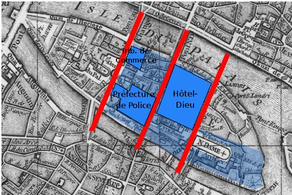
Paris, Ile de la Cité. A map based on the 1771 Robert de Vaugondy plan (cf File:Paris-cite-vaugondy-1771.jpg) and shows in dark blue the buildings, in light blue the public spaces and in red the streets created by Haussmann.
Derivated on a Gallica pic.
| Previous public domain rationale, no longer applicable | ||
|---|---|---|
|
היסטוריית הקובץ
ניתן ללחוץ על תאריך/שעה כדי לראות את הקובץ כפי שנראה באותו זמן.
| תאריך/שעה | תמונה ממוזערת | ממדים | משתמש | הערה | |
|---|---|---|---|---|---|
| נוכחית | 01:05, 17 בפברואר 2006 | | 402 × 602 (99 ק"ב) | Thbz | Paris, Ile de la Cité. A map based on the 1771 Vaugondy plan (cf Image:Paris-cite-vaugondy-1771.jpg) and shows in dark blue the buildings, in light blue the public spaces and in red the streets created by Haussmann. Derivated on a Gallica pic. {{G |
שימוש בקובץ
הדף הבא משתמש בקובץ הזה:
שימוש גלובלי בקובץ
אתרי הוויקי השונים הבאים משתמשים בקובץ זה:
- שימוש באתר ca.wikipedia.org
- שימוש באתר cs.wikipedia.org
- שימוש באתר en.wikipedia.org
- שימוש באתר fi.wikipedia.org
- שימוש באתר fr.wikipedia.org
- שימוש באתר it.wikipedia.org
- שימוש באתר ja.wikipedia.org
- שימוש באתר ru.wikipedia.org
- שימוש באתר uk.wikipedia.org