קובץ:Plan Rome- Regiones.png

גודל התצוגה המקדימה הזאת: 752 × 600 פיקסלים. רזולוציות אחרות: 301 × 240 פיקסלים | 602 × 480 פיקסלים | 963 × 768 פיקסלים | 1,128 × 900 פיקסלים.
לקובץ המקורי (1,128 × 900 פיקסלים, גודל הקובץ: 200 ק"ב, סוג MIME: image/png)
| זהו קובץ שמקורו במיזם ויקישיתוף. תיאורו בדף תיאור הקובץ המקורי (בעברית) מוצג למטה. |
| תיאור |
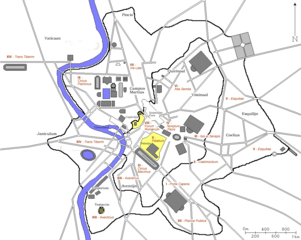
Nederlands: Kaart van antiek Rome. |
||
| תאריך יצירה | 2006/2007 | ||
| מקור |
Nederlands: Kaart is afkomstig van Franstalige Wikipedia en door Joris1919 naar een Nederlandse versie bewerkt. |
||
| יוצר | fr:User:ColdEel en nl:Gebruiker:Joris1919 | ||
| אישורים והיתרים (שימוש חוזר בקובץ זה) |
|
||
| גרסאות אחרות | fr:Image:AmphitheatreCastrense_planrome.png |
היסטוריית הקובץ
ניתן ללחוץ על תאריך/שעה כדי לראות את הקובץ כפי שנראה באותו זמן.
| תאריך/שעה | תמונה ממוזערת | ממדים | משתמש | הערה | |
|---|---|---|---|---|---|
| נוכחית | 22:18, 30 באפריל 2007 | | 900 × 1,128 (200 ק"ב) | Joris | {{Information |Description=Map of ancient Rome. |Source=Originally created for French Wikipedia Franstalige Wikipedia and edited by me to a Dutch version. |Date=2006/2007 |Author=fr:User:ColdEel en [[: |
| 22:16, 30 באפריל 2007 |  | 900 × 1,128 (200 ק"ב) | Joris | {{Information |Description=Map of ancient Rome. |Source=Originally created for French Wikipedia Franstalige Wikipedia and edited by me to a Dutch version. |Date=2006/2007 |Author=fr:User:ColdEel en [[: | |
| 18:08, 21 במרץ 2007 |  | 900 × 1,128 (206 ק"ב) | Joris | {{Information |Description=Kaart van antiek Rome. |Source=Kaart is afkomstig van Franstalige Wikipedia en door Joris1919 naar een Nederlandse versie bewerkt. |Date=2006/2007 |Author=fr:User:ColdEel en | |
| 13:11, 3 במרץ 2007 |  | 900 × 1,128 (114 ק"ב) | Evil berry | {{Information |Description=Kaart van antiek Rome. |Source=Kaart is afkomstig van Franstalige Wikipedia en door Joris1919 naar een Nederlandse versie bewerkt. |Date=2006/2007 |Author=fr:User:ColdEel en |
שימוש בקובץ
הדף הבא משתמש בקובץ הזה:
שימוש גלובלי בקובץ
אתרי הוויקי השונים הבאים משתמשים בקובץ זה:
- שימוש באתר cs.wikipedia.org
- שימוש באתר de.wikipedia.org
- שימוש באתר el.wikipedia.org
- שימוש באתר en.wikipedia.org
- שימוש באתר ja.wikipedia.org
- שימוש באתר la.wikipedia.org
- שימוש באתר nl.wikipedia.org
- שימוש באתר pt.wikipedia.org
- שימוש באתר ro.wikipedia.org
- שימוש באתר zh.wikipedia.org