קובץ:RegionsHungary.png
אין גרסה ברזולוציה גבוהה יותר.
RegionsHungary.png (760 × 500 פיקסלים, גודל הקובץ: 122 ק"ב, סוג MIME: image/png)
| זהו קובץ שמקורו במיזם ויקישיתוף. תיאורו בדף תיאור הקובץ המקורי (בעברית) מוצג למטה. |

|
יש ליצור מחדש את התמונה locator map הזו באמצעות גרפיקה וקטורית כדוגמת קובץ SVG. לפעולה זו מספר יתרונות, כפי שניתן לקרוא (באנגלית) בדף Commons:Media for cleanup. אם ברשותכם קובץ SVG, אנא העלו אותו. לאחר מכן, החליפו תבנית זו בתבנית
{{vector version available|שם הקובץ.svg}} |
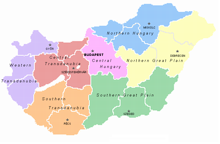
A map of the seven statistical regions of Hungary with their regional centres. It was made by User:Alensha by modifying the maps of the counties that also can be found here. If it means that the copyright is mine then I release it to public domain but if it belongs to the guy who made the pic Zalamegye.png from which it was modified, then it is GNU FDL.

|
מוענקת בכך הרשות להעתיק, להפיץ או לשנות את המסמך הזה, לפי תנאי הרישיון לשימוש חופשי במסמכים של גנו, גרסה 1.2 או כל גרסה מאוחרת יותר שתפורסם על־ידי המוסד לתוכנה חופשית; ללא פרקים קבועים, ללא טקסט עטיפה קדמית וללא טקסט עטיפה אחורית. עותק של הרישיון כלול בפרק שכותרתו הרישיון לשימוש חופשי במסמכים של גנו. |
| הקובץ הזה מתפרסם לפי תנאי רישיון קריאייטיב קומונז ייחוס-שיתוף זהה 3.0 לא מותאם. | ||
| ||
| תבנית רישוי זו הוספה לקובץ כחלק מעדכון רישיון GFDL. |
היסטוריית הקובץ
ניתן ללחוץ על תאריך/שעה כדי לראות את הקובץ כפי שנראה באותו זמן.
| תאריך/שעה | תמונה ממוזערת | ממדים | משתמש | הערה | |
|---|---|---|---|---|---|
| נוכחית | 16:09, 2 במרץ 2007 | | 500 × 760 (122 ק"ב) | Tene~commonswiki | Optimised (5) |
| 17:07, 21 במאי 2005 |  | 500 × 760 (164 ק"ב) | Alensha | A map of the seven statistical regions of Hungary with their regional centres. It was made by User:Alensha by modifying the maps of the counties that also can be found here. If it means that the copyright is mine then I release it to public domain but |
שימוש בקובץ
הדפים הבאים משתמשים בקובץ הזה:
שימוש גלובלי בקובץ
אתרי הוויקי השונים הבאים משתמשים בקובץ זה:
- שימוש באתר ast.wikipedia.org
- שימוש באתר az.wikipedia.org
- שימוש באתר be.wikipedia.org
- שימוש באתר bs.wikipedia.org
- שימוש באתר ca.wikipedia.org
- שימוש באתר da.wikipedia.org
- שימוש באתר de.wikipedia.org
- שימוש באתר el.wikipedia.org
- שימוש באתר en.wikipedia.org
- שימוש באתר es.wikipedia.org
- שימוש באתר fa.wikipedia.org
- שימוש באתר fr.wikipedia.org
- שימוש באתר gl.wikipedia.org
- שימוש באתר hr.wikipedia.org
- שימוש באתר kk.wikipedia.org
- שימוש באתר lt.wikipedia.org
- שימוש באתר mt.wikipedia.org
- שימוש באתר nl.wikipedia.org