קובץ:Reichskommissariat Ostland Administrative.png

גודל התצוגה המקדימה הזאת: 415 × 599 פיקסלים. רזולוציות אחרות: 166 × 240 פיקסלים | 333 × 480 פיקסלים | 532 × 768 פיקסלים | 710 × 1,024 פיקסלים | 1,420 × 2,048 פיקסלים | 2,856 × 4,120 פיקסלים.
לקובץ המקורי (2,856 × 4,120 פיקסלים, גודל הקובץ: 1.89 מ"ב, סוג MIME: image/png)
| זהו קובץ שמקורו במיזם ויקישיתוף. תיאורו בדף תיאור הקובץ המקורי (בעברית) מוצג למטה. |
תקציר
| תיאור |
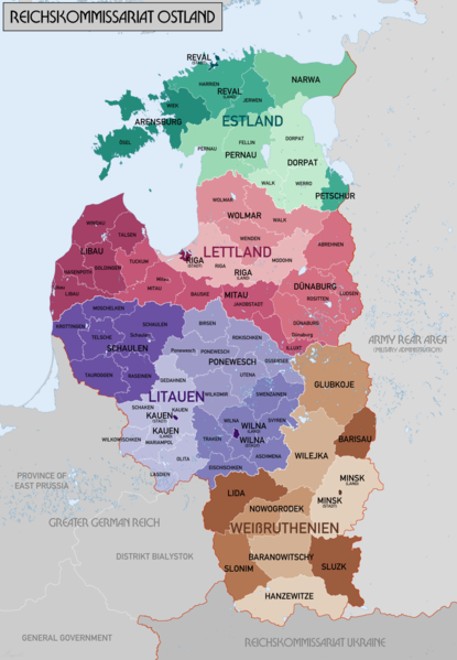
English: Administrative Map of Reichskommissariat Ostland |
| תאריך יצירה | |
| מקור | נוצר על־ידי מעלה היצירה |
| יוצר | XrysD |
| גרסאות אחרות |
Derivative works of this file: Gen Okrug Belarus Administrative.png Derivative works of this file: Generalbezirk Lettland.png |
רישיון
אני, בעל זכויות היוצרים על היצירה הזאת, מפרסם אותה בזאת תחת הרישיונות הבאים:

|
מוענקת בכך הרשות להעתיק, להפיץ או לשנות את המסמך הזה, לפי תנאי הרישיון לשימוש חופשי במסמכים של גנו, גרסה 1.2 או כל גרסה מאוחרת יותר שתפורסם על־ידי המוסד לתוכנה חופשית; ללא פרקים קבועים, ללא טקסט עטיפה קדמית וללא טקסט עטיפה אחורית. עותק של הרישיון כלול בפרק שכותרתו הרישיון לשימוש חופשי במסמכים של גנו. |
| הקובץ הזה מתפרסם לפי תנאי רישיון קריאייטיב קומונז ייחוס-שיתוף זהה 3.0 לא מותאם. | ||
| ||
| תבנית רישוי זו הוספה לקובץ כחלק מעדכון רישיון GFDL. |
| יוצרים זכויות (copyleft): יצירת האמנות הזאת חופשית; מותר לך להפיץ אותה או לשנות לפי תנאי רישיון אמנות חופשית (Free Art License). אפשר למצוא עותק של הרישיון הזה באתר Copyleft Attitude כמו גם באתרים אחרים. |
הנכם מוזמנים לבחור את הרישיון הרצוי בעיניכם.
היסטוריית הקובץ
ניתן ללחוץ על תאריך/שעה כדי לראות את הקובץ כפי שנראה באותו זמן.
| תאריך/שעה | תמונה ממוזערת | ממדים | משתמש | הערה | |
|---|---|---|---|---|---|
| נוכחית | 23:46, 20 בפברואר 2018 | | 4,120 × 2,856 (1.89 מ"ב) | XrysD | Changed map colours to use ColorBrewer Wikipedia recommended palette. |
| 16:33, 20 בפברואר 2018 |  | 4,120 × 2,856 (1.86 מ"ב) | XrysD | New version reduced legibility - e.g. borders in Riga District now invisible. | |
| 00:18, 16 בפברואר 2018 |  | 4,120 × 2,856 (2.62 מ"ב) | 1970gemini | fiat lux | |
| 20:47, 11 במאי 2017 |  | 4,120 × 2,856 (1.86 מ"ב) | XrysD | Fixed typo in source graphic and re-rendered output PNG to avoid loss of quality due to editing render rather than source. | |
| 17:58, 11 במאי 2017 |  | 4,120 × 2,856 (1.92 מ"ב) | Намѣсникъ | name of Dünaburg (not Dünaberg) corrected | |
| 19:25, 22 באפריל 2017 |  | 4,120 × 2,856 (1.71 מ"ב) | XrysD | Added missing labels | |
| 18:54, 22 באפריל 2017 |  | 4,120 × 2,856 (1.69 מ"ב) | XrysD | Completely new version. Source map data: [Karte des Deutschen Reiches (Grossblatter) 1:100k, Mapa Administracyjna Rzeczypospolitej Polska 1:300k, Verwaltungskarte_Weissruthenien_u.Ssmolensk_1M_Ausg.1_(B)_X.1942, 1:500k, Strassenkarte der Baltischen Lae... | |
| 19:50, 1 בספטמבר 2015 |  | 2,139 × 1,548 (1.04 מ"ב) | Poeticbent | added missing subdivisions | |
| 01:03, 20 בספטמבר 2008 |  | 2,139 × 1,548 (962 ק"ב) | XrysD | {{Information |Description={{en|1=Administrative Map of Reichskommissariat Ostland}} |Source=Own work by uploader |Author=XrysD |Date=19/09/2008 |Permission= |other_versions= }} <!--{{ImageUpload|full}}--> |
שימוש בקובץ
הדף הבא משתמש בקובץ הזה:
שימוש גלובלי בקובץ
אתרי הוויקי השונים הבאים משתמשים בקובץ זה:
- שימוש באתר ar.wikipedia.org
- שימוש באתר az.wikipedia.org
- שימוש באתר be-tarask.wikipedia.org
- שימוש באתר be.wikipedia.org
- שימוש באתר bs.wikipedia.org
- שימוש באתר ca.wikipedia.org
- שימוש באתר cs.wikipedia.org
- שימוש באתר da.wikipedia.org
- שימוש באתר de.wikipedia.org
- שימוש באתר en.wikipedia.org
- Reichskommissariat Ostland
- Demographic history of the Vilnius region
- Reichskommissariat
- German occupation of Lithuania during World War II
- Generalbezirk Litauen
- Wikipedia:WikiProject Military history/News/August 2012/Op-ed
- Generalbezirk Estland
- Generalbezirk Lettland
- Walther Schröder
- Karl Schäfer (SS-Brigadeführer)
- Generalbezirk Weißruthenien
- Talk:Lithuanian Territorial Defense Force/Archive 1
- שימוש באתר es.wikipedia.org
- שימוש באתר et.wikipedia.org
- שימוש באתר fi.wikipedia.org