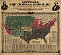
קובץ:Reynolds's Political Map of the United States 1856.jpg

גודל התצוגה המקדימה הזאת: 661 × 600 פיקסלים. רזולוציות אחרות: 265 × 240 פיקסלים | 529 × 480 פיקסלים | 846 × 768 פיקסלים | 1,128 × 1,024 פיקסלים | 2,257 × 2,048 פיקסלים | 7,813 × 7,090 פיקסלים.
לקובץ המקורי (7,813 × 7,090 פיקסלים, גודל הקובץ: 19.76 מ"ב, סוג MIME: image/jpeg)
היסטוריית הקובץ
ניתן ללחוץ על תאריך/שעה כדי לראות את הקובץ כפי שנראה באותו זמן.
| תאריך/שעה | תמונה ממוזערת | ממדים | משתמש | הערה | |
|---|---|---|---|---|---|
| נוכחית | 21:29, 16 באוגוסט 2023 |  | 7,090 × 7,813 (19.76 מ"ב) | Jengod | Autotune so brighter and easier to read |
| 10:28, 22 באפריל 2016 |  | 7,090 × 7,813 (35.27 מ"ב) | Khamar | Original improved in Adobe Photoshop by removing white strip through center where left and right sides of map join, removing some dark and white stripes from image, and nudging some of the text and lines back into alignment preserving as much of the ma... | |
| 04:40, 17 בדצמבר 2012 |  | 7,090 × 7,828 (16.56 מ"ב) | T3hBra1nWa5her | Higher resolution version from the [http://memory.loc.gov/cgi-bin/query/h?ammem/gmd:@field(NUMBER+@band(g3701e+ct000604)) Library of Congress Geography and Map Division Washington]. | |
| 16:15, 1 באוגוסט 2008 |  | 1,736 × 2,000 (709 ק"ב) | Bdamokos | {{Information |Description={{en|US map 1856 shows free and slave states and populations; this is "Reynolds's Political Map of the United States" (1856) from Library of Congress collection[http://lcweb2.loc.gov/ammem/aaohtml/exhibit/aopart3b.html] [[:en |
שימוש בקובץ
הדפים הבאים משתמשים בקובץ הזה:
שימוש גלובלי בקובץ
אתרי הוויקי השונים הבאים משתמשים בקובץ זה:
- שימוש באתר ar.wikipedia.org
- שימוש באתר ca.wikipedia.org
- שימוש באתר de.wikipedia.org
- שימוש באתר en.wikipedia.org
- שימוש באתר en.wikiquote.org
- שימוש באתר es.wikipedia.org
- שימוש באתר fa.wikipedia.org
- שימוש באתר fi.wikipedia.org
- שימוש באתר fr.wikipedia.org
- שימוש באתר hu.wikipedia.org
- שימוש באתר id.wikipedia.org
- שימוש באתר it.wikipedia.org
- שימוש באתר ja.wikipedia.org
- שימוש באתר ko.wikipedia.org
- שימוש באתר no.wikipedia.org
- שימוש באתר pl.wikipedia.org
- שימוש באתר pt.wikipedia.org
- שימוש באתר ro.wikipedia.org
- שימוש באתר ru.wikipedia.org
- שימוש באתר sh.wikipedia.org
- שימוש באתר simple.wikipedia.org
- שימוש באתר sv.wikipedia.org