קובץ:SDBayAreaNASA.jpg

גודל התצוגה המקדימה הזאת: 600 × 600 פיקסלים. רזולוציות אחרות: 240 × 240 פיקסלים | 480 × 480 פיקסלים | 768 × 768 פיקסלים | 1,024 × 1,024 פיקסלים | 2,048 × 2,048 פיקסלים | 4,055 × 4,055 פיקסלים.
לקובץ המקורי (4,055 × 4,055 פיקסלים, גודל הקובץ: 13.45 מ"ב, סוג MIME: image/jpeg)
| זהו קובץ שמקורו במיזם ויקישיתוף. תיאורו בדף תיאור הקובץ המקורי (בעברית) מוצג למטה. |
תקציר
| תיאור |
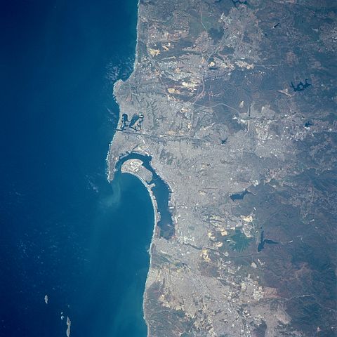
English: Three major features dominate this image of the southwest coast of California: the deep blue (dark) waters of the Pacific Ocean; the highly reflective, man-made urban and suburban environment along the coast; and the rugged, natural terrain of low mountain foothills of the Peninsular Ranges east of the urban development. The greater metropolitan area of San Diego (CA) and Tijuana (Mexico) with a combined population of approximately four million people can be identified as the lighter colored, highly reflective area on the image. Several types of infrastructure associated with the developed urban area are visible on this small-scale image. Reservoirs, including the lower Otay, Sweetwater, and St. Vicente Reservoirs, are the irregularly shaped, dark blue areas. The light-colored linear runways of Miramar Naval Air Station lie north of the densely populated area of San Diego. Interstate Highways 5 and 15 (light colored, linear features) radiate northward away from San Diego. The small square-shaped features along the edges of the bay are the many piers that jut into San Diego Bay. Mission Bay Harbor and Marina (dark area) is found along the coast north of the entrance to San Diego Bay. |
| תאריך יצירה | 20 באפריל 1998, 19:45:12 UTC |
| מקור | Image courtesy of Earth Sciences and Image Analysis Laboratory, NASA Johnson Space Center: NASA photo STS090-758-17 (mission STS090, roll 758, frame 17); high-resolution version from ftp://eol.jsc.nasa.gov/EFS_highres_STS090_STS090-758-17.JPG |
| יוצר | NASA |
| מיקום המצלמה | | תמונה זו ותמונות נוספות במיקום: OpenStreetMap |
|---|
רישיון
| קובץ זה נמצא ברשות הציבור מכיוון שהוא נוצר על ידי נאס"א. מדיניות זכויות היוצרים של נאס"א קובעת ש"חומרים של NASA אינם מוגנים בזכויות יוצרים אלא אם צוין אחרת". (דף מדיניות זכויות היוצרים ב-NASA או מדיניות שימוש בתמונות ב-JPL). | ||
 |
אזהרות:
|
| Annotations | This image is annotated: View the annotations at Commons |
היסטוריית הקובץ
ניתן ללחוץ על תאריך/שעה כדי לראות את הקובץ כפי שנראה באותו זמן.
| תאריך/שעה | תמונה ממוזערת | ממדים | משתמש | הערה | |
|---|---|---|---|---|---|
| נוכחית | 01:24, 1 ביולי 2012 | | 4,055 × 4,055 (13.45 מ"ב) | Closeapple | high-resolution version from ftp://eol.jsc.nasa.gov/EFS_highres_STS090_STS090-758-17.JPG |
| 03:16, 16 בפברואר 2011 |  | 639 × 639 (344 ק"ב) | 08OceanBeach SD | brightened | |
| 03:10, 24 בינואר 2011 |  | 639 × 639 (322 ק"ב) | 08OceanBeach SD | {{Information |Description ={{en|1=Satellite map of the San Diego Urban and Bay Area from the National Aeronautics and Space Administration. Three major features dominate this image of the southwest coast of California: |
שימוש בקובץ
הדף הבא משתמש בקובץ הזה:
שימוש גלובלי בקובץ
אתרי הוויקי השונים הבאים משתמשים בקובץ זה:
- שימוש באתר ceb.wikipedia.org
- שימוש באתר de.wikipedia.org
- שימוש באתר en.wikipedia.org
- שימוש באתר eo.wikipedia.org
- שימוש באתר es.wikipedia.org
- שימוש באתר fr.wikipedia.org
- שימוש באתר it.wikipedia.org
- שימוש באתר nl.wikipedia.org
- שימוש באתר pl.wikipedia.org
- שימוש באתר ru.wikipedia.org
- שימוש באתר www.wikidata.org