קובץ:Saint Chely Tarn.jpg
גודל התצוגה המקדימה הזאת: 800 × 360 פיקסלים. רזולוציות אחרות: 320 × 144 פיקסלים | 640 × 288 פיקסלים | 1,024 × 461 פיקסלים | 1,280 × 577 פיקסלים | 2,560 × 1,153 פיקסלים | 6,609 × 2,977 פיקסלים.
לקובץ המקורי (6,609 × 2,977 פיקסלים, גודל הקובץ: 13.36 מ"ב, סוג MIME: image/jpeg)
| זהו קובץ שמקורו במיזם ויקישיתוף. תיאורו בדף תיאור הקובץ המקורי (בעברית) מוצג למטה. |
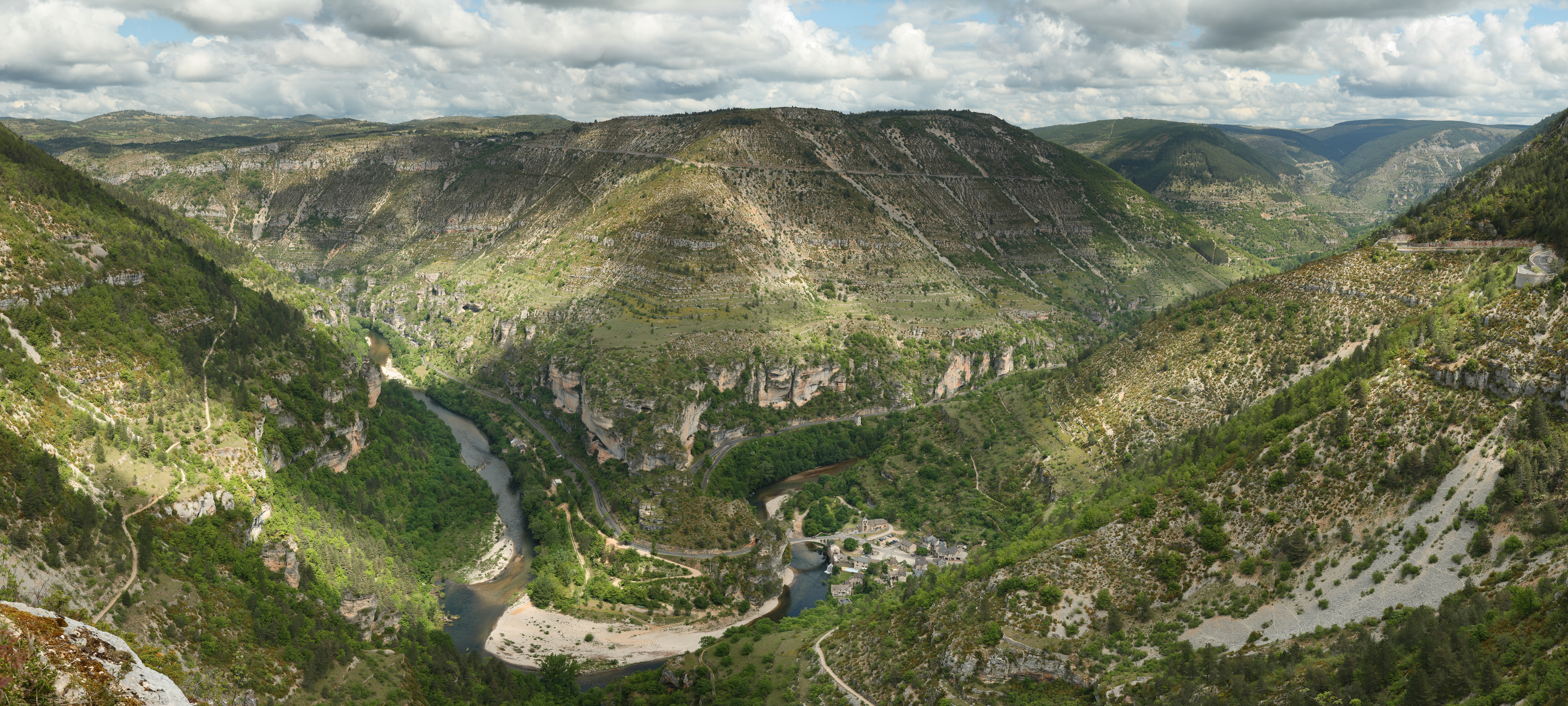
תמונה זו נבחרה כתמונת היום בתאריך 13 בפברואר 2010. כותרתה: English: View over the cirque of Pougnadoires and Saint-Chély-du-Tarn village, in the Tarn Gorges, from the cirque of Saint-Chély, France. שפות אחרות:
Bosanski: Pogled preko cirka Pougnadoires i sela Saint-Chély-du-Tarn, u kanjonu rijeke Tarn, iz cirka Saint-Chély, Francuska Català: Vista del circ glacial de Pougnadoires, en les gorgues del Tarn, al municipi occità de Santa Enimia, França. Dansk: Udsigt over kedeldalen Pougnadoires og landsbyen Saint-Chély-du-Tarn i Gorges du Tarn i Cevennerne i Frankrig. Deutsch: Die Gorges du Tarn mit dem Dorf Saint-Chély-du-Tarn English: View over the cirque of Pougnadoires and Saint-Chély-du-Tarn village, in the Tarn Gorges, from the cirque of Saint-Chély, France. Español: Vista del circo glaciar de Pougnadoires y del pueblo de Saint-Chély-du-Tarn, en las gargantas del rio Tarn, Francia. Français : Vue du cirque de Pougnadoires et du village de Saint-Chély-du-Tarn, dans les gorges du Tarn, France. Italiano: Panoramica del circo glaciale del Pougnadoires e del villaggio di Saint-Chély-du-Tarn, nelle Gole del Tarn, in Francia. Magyar: A Tarn folyó szurdokvölgyének panorámaképe a languedoc-roussilloni Saint-Chély-du-Tarn település közelében Nederlands: Gezicht over het keteldal (cirque) van de Franse dorpen Pougnadoires en Saint-Chély-du-Tarn in de Gorges du Tarn, gezien vanaf het keteldal van Saint-Chély Polski: Widok na dolinę rzeki Tarn we Francji. Svenska: Byn Saint-Chély-du-Tarn vid floden Tarns dalgång i Frankrike. Русский: Вид горного цирка Пуньядуар и села Сен-Шели-дю-Тарн, которое лежит в долине реки Тарн, Франция Українська: Вигляд гірського цирку Пундуар і села Сент-Шелі-дю-Тарн, яке лежить в тіснині річки Тарн, Франція. বাংলা : ফ্রান্সের টার্ন গর্জেসে অবস্থিত সেই শিলে দু-টার্ন গ্রামের একটি দৃশ্য। 中文: 法国塔尔恩峽谷普格纳杜瓦勒和塔尔恩的圣谢里村风景 中文(繁體): 法國塔爾恩峽谷普格納杜瓦勒和塔爾恩的聖謝里村風景 |
|
תקציר
| תיאור |
English: View over the cirque of Pougnadoires and Saint-Chély-du-Tarn village, in the Tarn Gorges, from the cirque of Saint-Chély. This picture features the road D 907bis which goes alongside the Tarn river all along the gorges. This picture is a mosaic of 14 pictures taken at 43mm, f/8.0, 1/250s and ISO 100. Stitching was done with Hugin and Enblend. Resulting hozirontal FOV is 118°.
Français : Vue du cirque de Pougnadoires et du village de Saint-Chély-du-Tarn, dans les gorges du Tarn. Cette photo a été prise d'un belvédère du bord de la D986, sur le cirque de Saint-Chély. On aperçoit sur le bas du versant opposé la départementale 907bis qui longe le Tarn dans ses gorges par la rive droite. Cette image a été réalisée à partir de 14 photos prises à 43mm, f/8.0, 1/250s et ISO 100. Le collage a été réalisé avec Hugin et Enblend. Le champ de vision horizontal résultant est de 118°. |
| תאריך יצירה | |
| מקור | נוצר על־ידי מעלה היצירה |
| יוצר | Benh LIEU SONG |
| מיקום המצלמה | | תמונה זו ותמונות נוספות במיקום: OpenStreetMap |
|---|
רישיון
אני, בעל זכויות היוצרים על עבודה זו, מפרסם בזאת את העבודה תחת הרישיון הבא:
הקובץ הזה מתפרסם לפי תנאי רישיון קריאייטיב קומונז ייחוס-שיתוף זהה 3.0 לא מותאם.
- הנכם רשאים:
- לשתף – להעתיק, להפיץ ולהעביר את העבודה
- לערבב בין עבודות – להתאים את העבודה
- תחת התנאים הבאים:
- ייחוס – יש לתת ייחוס הולם, לתת קישור לרישיון, ולציין אם נעשו שינויים. אפשר לעשות את זה בכל צורה סבירה, אבל לא בשום צורה שמשתמע ממנה שמעניק הרישיון תומך בך או בשימוש שלך.
- שיתוף זהה – אם תיצרו רמיקס, תשנו, או תבנו על החומר, חובה עליכם להפיץ את התרומות שלך לפי תנאי רישיון זהה או תואם למקור.
היסטוריית הקובץ
ניתן ללחוץ על תאריך/שעה כדי לראות את הקובץ כפי שנראה באותו זמן.
| תאריך/שעה | תמונה ממוזערת | ממדים | משתמש | הערה | |
|---|---|---|---|---|---|
| נוכחית | 21:12, 12 באוגוסט 2008 | | 2,977 × 6,609 (13.36 מ"ב) | Benh | Changed colors. I believe this is more true to what I saw. |
| 01:56, 8 ביוני 2008 |  | 2,970 × 6,609 (9.59 מ"ב) | Benh | {{Information |Description={{en|1=View over the cirque of Pougnadoire and Saint-Chély of Tarn village, in the Tarn Gorges, from the cirque of Saint-Chély. This picture features the road D 907bis which goes alongside the Tarn river all along the gorges.} |
שימוש בקובץ
הדפים הבאים משתמשים בקובץ הזה:
שימוש גלובלי בקובץ
אתרי הוויקי השונים הבאים משתמשים בקובץ זה:
- שימוש באתר ar.wikipedia.org
- שימוש באתר az.wikipedia.org
- שימוש באתר bn.wikipedia.org
- שימוש באתר ceb.wikipedia.org
- שימוש באתר crh.wikipedia.org
- שימוש באתר cs.wikipedia.org
- שימוש באתר cv.wikipedia.org
- שימוש באתר de.wikipedia.org
- שימוש באתר de.wikivoyage.org
- שימוש באתר el.wikipedia.org
- שימוש באתר en.wikipedia.org
- Lozère
- Massif Central
- Wikipedia:Featured pictures/Places/Panorama
- User talk:Blieusong
- Wikipedia:Featured pictures thumbs/12
- Wikipedia:Picture peer review/Archives/Apr-Jun 2008
- Saint-Chély-du-Tarn
- Wikipedia:Picture peer review/Saint Chely Tarn
- Wikipedia:Featured picture candidates/Saint Chely Tarn
- Wikipedia:Featured picture candidates/July-2008
- Wikipedia:Wikipedia Signpost/2008-07-07/Features and admins
- Wikipedia:Wikipedia Signpost/2008-07-07/SPV
- Wikipedia:Picture of the day/December 2008
- Template:POTD/2008-12-27
- Portal:Roads/Selected panorama
- Portal:Roads/Selected panorama/8
- User talk:Mostlyharmless/Archive 2
- Wikipedia:Wikipedia Signpost/Single/2008-07-07
- שימוש באתר eo.wikipedia.org
- שימוש באתר es.wikipedia.org
- שימוש באתר fr.wikipedia.org
- שימוש באתר fr.wikivoyage.org