קובץ:Sassanid-empire.gif
אין גרסה ברזולוציה גבוהה יותר.
Sassanid-empire.gif (600 × 480 פיקסלים, גודל הקובץ: 101 ק"ב, סוג MIME: image/gif)
| זהו קובץ שמקורו במיזם ויקישיתוף. תיאורו בדף תיאור הקובץ המקורי (בעברית) מוצג למטה. |
תקציר
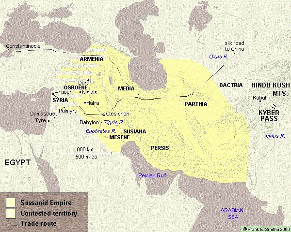
The normal borders of the great Sassanid Empire during much of its existence. (Map by Frank Smitha used by permission granted on December 15, 2006 by his agent, Marilynn Bell.)
רישיון

|
The copyright holder of this work allows anyone to use it for any purpose including unrestricted redistribution, commercial use, and modification.
Usage notes:
|
Atlas
This map should be added to the Wikimedia Atlas.
היסטוריית הקובץ
ניתן ללחוץ על תאריך/שעה כדי לראות את הקובץ כפי שנראה באותו זמן.
| תאריך/שעה | תמונה ממוזערת | ממדים | משתמש | הערה | |
|---|---|---|---|---|---|
| נוכחית | 10:50, 14 ביוני 2017 | | 480 × 600 (101 ק"ב) | Babak2000ir | The label: Persian Gulf is added. For the better historical context and more accuracy. |
| 10:48, 14 ביוני 2017 |  | 480 × 600 (21 ק"ב) | Babak2000ir | Reverted to version as of 23:13, 15 December 2006 (UTC) | |
| 10:46, 14 ביוני 2017 |  | 480 × 600 (101 ק"ב) | Babak2000ir | The label: Persian Gulf is added. For the better historical context and more accuracy. | |
| 02:13, 16 בדצמבר 2006 |  | 480 × 600 (21 ק"ב) | Larry Dunn | The normal borders of the great Sassanid Empire during much of its existence. |
שימוש בקובץ
הדף הבא משתמש בקובץ הזה:
שימוש גלובלי בקובץ
אתרי הוויקי השונים הבאים משתמשים בקובץ זה:
- שימוש באתר azb.wikipedia.org
- שימוש באתר el.wikipedia.org
- שימוש באתר en.wikipedia.org
- שימוש באתר fa.wikipedia.org
- שימוש באתר fr.wikipedia.org
- שימוש באתר it.wikipedia.org
- שימוש באתר ka.wikipedia.org
- שימוש באתר tr.wikipedia.org
- שימוש באתר uk.wikipedia.org