קובץ:SeamontDavidson expedition bathymetric-2002.jpg
אין גרסה ברזולוציה גבוהה יותר.
SeamontDavidson_expedition_bathymetric-2002.jpg (600 × 478 פיקסלים, גודל הקובץ: 59 ק"ב, סוג MIME: image/jpeg)
| זהו קובץ שמקורו במיזם ויקישיתוף. תיאורו בדף תיאור הקובץ המקורי (בעברית) מוצג למטה. |
תקציר
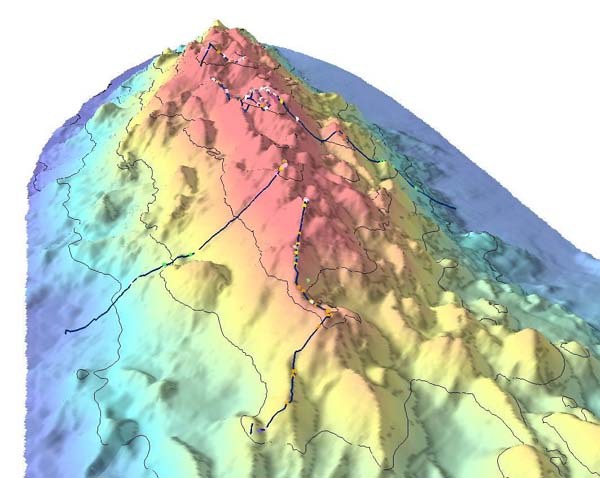
| תיאור |
English: Bathymetric showing details of part of Davidson Seamount. The lines indicate the path of the 2002 expedition, and the dots signifigant coral nurseries
Français : Relevé bathymétrique montrant les détails du relief sous-marin du Mont Davidson. les lignes indiquent les lieux étudiés par l'expédition de 2002, et les points désignent les surseries coralliennes |
| תאריך יצירה | import on Commons : 2010/10/30 |
| מקור | Direct link File page |
| יוצר | C. King/[1]/[2] |
| אישורים והיתרים (שימוש חוזר בקובץ זה) |
The above two organizations are a part of NOAA; thus it is public domain (see below) |
רישיון
This image is in the public domain because it contains materials that originally came from the U.S. National Oceanic and Atmospheric Administration, taken or made as part of an employee's official duties.
|
היסטוריית הקובץ
ניתן ללחוץ על תאריך/שעה כדי לראות את הקובץ כפי שנראה באותו זמן.
| תאריך/שעה | תמונה ממוזערת | ממדים | משתמש | הערה | |
|---|---|---|---|---|---|
| נוכחית | 11:21, 30 באוקטובר 2010 | | 478 × 600 (59 ק"ב) | Lamiot | {{Information |Description= {{en|Bathymetric showing details of part of Davidson Seamount. The lines indicate the path of the 2002 expedition, and the dots signifigant coral nurseries}} {{fr|Relevé bathymétrique montrant les détails du relief sous-mari |
שימוש בקובץ
הדף הבא משתמש בקובץ הזה:
שימוש גלובלי בקובץ
אתרי הוויקי השונים הבאים משתמשים בקובץ זה:
- שימוש באתר bs.wikipedia.org
- שימוש באתר en.wikipedia.org
- שימוש באתר fa.wikipedia.org
- שימוש באתר fr.wikipedia.org
- שימוש באתר gl.wikipedia.org
- שימוש באתר mk.wikipedia.org
- שימוש באתר nl.wikipedia.org
- שימוש באתר simple.wikipedia.org
- שימוש באתר sr.wikipedia.org
- שימוש באתר th.wikipedia.org
- שימוש באתר tr.wikipedia.org
- שימוש באתר tt.wikipedia.org
- שימוש באתר www.wikidata.org