קובץ:Soho - map 1.png
Soho_-_map_1.png (626 × 525 פיקסלים, גודל הקובץ: 422 ק"ב, סוג MIME: image/png)
| זהו קובץ שמקורו במיזם ויקישיתוף. תיאורו בדף תיאור הקובץ המקורי (בעברית) מוצג למטה. |
| תיאור |
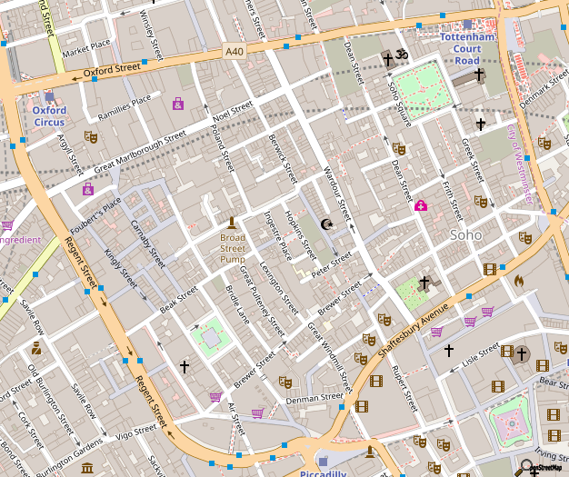
Map of Soho, London This map of London was created from OpenStreetMap project data, collected by the community. This map may be incomplete, and may contain errors. Don't rely solely on it for navigation. |
|||||||||
| תאריך יצירה | ||||||||||
| מקור | You may find a page on the OpenStreetMap wiki page for Soho | |||||||||
| יוצר |
OpenStreetMap contributors |
|||||||||
| אישורים והיתרים (שימוש חוזר בקובץ זה) |
OpenStreetMap data is available under the Open Database License (details). Map tiles are licensed under the Creative Commons Attribution-ShareAlike 2.0 license (CC-BY-SA 2.0).
הקובץ הזה מתפרסם לפי תנאי רישיון קריאייטיב קומונז ייחוס-שיתוף זהה 2.0 כללי.
|
|||||||||
| Geotemporal data | ||||||||||
| Bounding box |
|
|||||||||
| Georeferencing | If inappropriate please set warp_status = skip to hide. | |||||||||
To see a more up-to-date OpenStreetMap view of this area: http://www.openstreetmap.org/#map=16/51.5129/-0.1343
...or generate this exact image: http://staticmap.openstreetmap.de/staticmap.php?center=51.5131,-0.13546&zoom=16&size=626x525
This map is available as SVG from the OpenStreetMap-Server however the file is 4.3MB big and uses 1.2GB of RAM for rendering in Inkscape 0.46, so it's better to keep this version. Here's the SVG link: http://tile.openstreetmap.org/cgi-bin/export?bbox=-0.14283,51.50958,-0.12871,51.51714&scale=6800&format=svg
היסטוריית הקובץ
ניתן ללחוץ על תאריך/שעה כדי לראות את הקובץ כפי שנראה באותו זמן.
| תאריך/שעה | תמונה ממוזערת | ממדים | משתמש | הערה | |
|---|---|---|---|---|---|
| נוכחית | 17:06, 29 באוקטובר 2018 | | 525 × 626 (422 ק"ב) | Wvdp | updates from osm |
| 21:05, 23 בדצמבר 2017 |  | 525 × 626 (415 ק"ב) | Wvdp | update | |
| 14:57, 2 בנובמבר 2015 |  | 525 × 626 (396 ק"ב) | FranklyMyDear... | Significant cartographic style change to the roads | |
| 00:55, 15 ביולי 2015 |  | 525 × 626 (360 ק"ב) | Harry Wood | update for 2015 with improved building coverage in the map data + more recent 'standard' OpenStreetMap style. Also "improving the resolution" back again closer to the native resolution | |
| 04:00, 5 בינואר 2013 |  | 1,735 × 2,248 (2.12 מ"ב) | John Aplessed | Improved resolution, updated design and contents, imaged zoomed out one level (original zoom level doesn't exist) | |
| 09:01, 9 בינואר 2008 |  | 525 × 626 (151 ק"ב) | Grenavitar | version without 401 label messed up | |
| 19:23, 18 בדצמבר 2007 |  | 531 × 601 (145 ק"ב) | IgnoredAmbience | ||
| 04:35, 27 בפברואר 2007 |  | 511 × 620 (65 ק"ב) | Edward | {{Information |Description=Map of w:Soho |Source=OpenStreetMap |Date=2007-02-27 |Author=Edward Betts |Permission={{cc-by-sa-2.0}} }} Category:Maps of London Category:OpenStreetMap maps |
שימוש בקובץ
הדפים הבאים משתמשים בקובץ הזה:
שימוש גלובלי בקובץ
אתרי הוויקי השונים הבאים משתמשים בקובץ זה:
- שימוש באתר ar.wikipedia.org
- שימוש באתר be.wikipedia.org
- שימוש באתר bg.wikipedia.org
- שימוש באתר ceb.wikipedia.org
- שימוש באתר da.wikipedia.org
- שימוש באתר de.wikipedia.org
- שימוש באתר el.wikipedia.org
- שימוש באתר en.wikipedia.org
- שימוש באתר en.wikinews.org
- שימוש באתר eo.wikipedia.org
- שימוש באתר fa.wikipedia.org
- שימוש באתר id.wikipedia.org
- שימוש באתר ja.wikipedia.org
- שימוש באתר km.wikipedia.org
- שימוש באתר kn.wikipedia.org
- שימוש באתר ko.wikipedia.org
- שימוש באתר no.wikipedia.org
- שימוש באתר pl.wikipedia.org
- שימוש באתר ru.wikipedia.org
- שימוש באתר simple.wikipedia.org
- שימוש באתר si.wikipedia.org
- שימוש באתר sk.wikipedia.org
- שימוש באתר sl.wikipedia.org
- שימוש באתר sr.wikipedia.org
- שימוש באתר te.wikipedia.org
- שימוש באתר tr.wikipedia.org
- שימוש באתר uk.wikipedia.org
- שימוש באתר war.wikipedia.org
- שימוש באתר www.wikidata.org
- שימוש באתר zh.wikipedia.org