קובץ:Southeast mediterranean annotated geography.jpg

גודל התצוגה המקדימה הזאת: 275 × 599 פיקסלים. רזולוציות אחרות: 110 × 240 פיקסלים | 220 × 480 פיקסלים | 831 × 1,809 פיקסלים.
לקובץ המקורי (831 × 1,809 פיקסלים, גודל הקובץ: 525 ק"ב, סוג MIME: image/jpeg)
| זהו קובץ שמקורו במיזם ויקישיתוף. תיאורו בדף תיאור הקובץ המקורי (בעברית) מוצג למטה. |
תקציר
| תיאור |
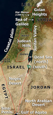
Annotated satellite image of Israel, the Palestinian territories and western Jordan, highlighting principal geographical features. Based on Image:Satellite image of Israel in January 2003.jpg If anyone wants to adapt this for a different language, please contact me (ChrisO) - I can send the original .PSD file. |
| תאריך יצירה | 27 במרץ 2007 (תאריך העלאה מקורי) |
| מקור | לא סופק מקור מכונה קריא. ההנחה היא כי היצירה נוצרה על ידי מעלה היצירה (בהתבסס על תבנית הרישיון). |
| יוצר | לא סופק יוצר ששמו ניתן לקריאה במכונה. בהתבסס על תביעות זכויות יוצרים, ההנחה היא כי ChrisO הוא היוצר. |
רישיון
| קובץ זה נמצא ברשות הציבור מכיוון שהוא נוצר על ידי נאס"א. מדיניות זכויות היוצרים של נאס"א קובעת ש"חומרים של NASA אינם מוגנים בזכויות יוצרים אלא אם צוין אחרת". (דף מדיניות זכויות היוצרים ב-NASA או מדיניות שימוש בתמונות ב-JPL). | ||
 |
אזהרות:
|
| ברצוני, בעלי זכויות היוצרים על יצירה זו, לשחרר יצירה זו לנחלת הכלל. זה תקף בכל העולם. יש מדינות שבהן הדבר אינו אפשרי על פי חוק, אם כך: אני מעניק לכל אחד את הזכות להשתמש בעבודה זו לכל מטרה שהיא, ללא תנאים כלשהם, אלא אם כן תנאים כאלה נדרשים על פי חוק. |
היסטוריית הקובץ
ניתן ללחוץ על תאריך/שעה כדי לראות את הקובץ כפי שנראה באותו זמן.
| תאריך/שעה | תמונה ממוזערת | ממדים | משתמש | הערה | |
|---|---|---|---|---|---|
| נוכחית | 00:24, 28 במרץ 2007 | | 1,809 × 831 (525 ק"ב) | ChrisO | Annotated satellite image of Israel, the Palestinian territories and western Jordan, highlighting principal geographical features. Based on Image:Satellite image of Israel in January 2003.jpg ''If anyone wants to adapt this for a different language |
שימוש בקובץ
![]() אין בוויקיפדיה דפים המשתמשים בקובץ זה.
אין בוויקיפדיה דפים המשתמשים בקובץ זה.
שימוש גלובלי בקובץ
אתרי הוויקי השונים הבאים משתמשים בקובץ זה:
- שימוש באתר ca.wikipedia.org
- שימוש באתר da.wikipedia.org
- שימוש באתר en.wikipedia.org
- שימוש באתר es.wikipedia.org
- שימוש באתר fr.wikipedia.org
- שימוש באתר ha.wikipedia.org
- שימוש באתר incubator.wikimedia.org
- שימוש באתר it.wikipedia.org
- שימוש באתר jv.wikipedia.org
- שימוש באתר ko.wikipedia.org
- שימוש באתר pt.wikipedia.org
- שימוש באתר su.wikipedia.org
- שימוש באתר uk.wikipedia.org
- שימוש באתר www.wikidata.org