קובץ:Trinity Test Fireball 16ms.jpg
גודל התצוגה המקדימה הזאת: 800 × 539 פיקסלים. רזולוציות אחרות: 320 × 216 פיקסלים | 640 × 432 פיקסלים | 1,024 × 690 פיקסלים | 1,483 × 1,000 פיקסלים.
לקובץ המקורי (1,483 × 1,000 פיקסלים, גודל הקובץ: 215 ק"ב, סוג MIME: image/jpeg)
| זהו קובץ שמקורו במיזם ויקישיתוף. תיאורו בדף תיאור הקובץ המקורי (בעברית) מוצג למטה. |
|
This is an image of a place or building that is listed on the National Register of Historic Places in the United States of America. Its reference number is 66000493. |
|
תקציר
| תיאור |
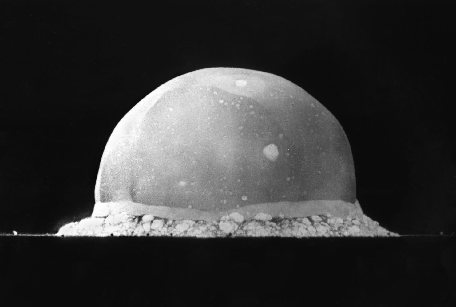
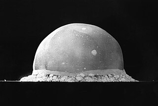
English: PA-98-0520 — Trinity Site explosion, 0.016 second after explosion, July 16, 1945. The viewed hemisphere's highest point in this image is about 200 meters high.
Türkçe: 16 Temmuz 1945 yılında New Mexico'daki Socorro'nın 56 km kadar güneydoğusunda şu an üzerinde komuta merkezi Alamogordo'da bulunan White Sands Missile Range'in bulunduğu yerde yapılmış Trinity patlamasının, infilak anından 0,016 sn sonra çekilmiş görüntüsüdür. Görüntülenen yarım kürenin en yüksek noktası yaklaşık 200 metre yüksekliğindedir.
Deutsch: Foto des Trinity-Tests, 16ms nach der Zündung am 16. Juli 1945. Die im Bild sichtbaren Feuerblase hat zu diesem Zeitpunkt eine Höhe von ca. 200 Metern. |
||||||
| תאריך יצירה | |||||||
| מקור | http://www.lanl.gov/orgs/pa/photos/images/PA-98-0520.jpeg | ||||||
| יוצר | Berlyn Brixner / Los Alamos National Laboratory | ||||||
| אישורים והיתרים (שימוש חוזר בקובץ זה) |
|
||||||

| מיקום המצלמה | | תמונה זו ותמונות נוספות במיקום: OpenStreetMap |
|---|
היסטוריית הקובץ
ניתן ללחוץ על תאריך/שעה כדי לראות את הקובץ כפי שנראה באותו זמן.
| תאריך/שעה | תמונה ממוזערת | ממדים | משתמש | הערה | |
|---|---|---|---|---|---|
| נוכחית | 05:13, 8 ביוני 2008 | | 1,000 × 1,483 (215 ק"ב) | File Upload Bot (Magnus Manske) | {{BotMoveToCommons|en.wikipedia}} {{Information |Description={{en|PA-98-0520 -- Trinity Site explosion, .016 seconds after explosion, July 16, 1945. :URL: http://www.lanl.gov/orgs/pa/photos/images/PA-98-0520.jpeg :Photo Credit: Los Alamos National Labora |
שימוש בקובץ
הדפים הבאים משתמשים בקובץ הזה:
- ניסוי בנשק גרעיני
- משתמש:Tomer T/תמונות שהצעתי
- ויקיפדיה:תמונה מומלצת/הוספה למומלצים/ארכיון 124
- ויקיפדיה:תמונה מומלצת/המלצות קודמות/ינואר 2020
- ויקיפדיה:תמונה מומלצת/המלצות קודמות/פברואר 2023
- תבנית:תמונה מומלצת 25 בינואר 2020
- תבנית:תמונה מומלצת 25 בפברואר 2023
- פורטל:מלחמת העולם השנייה/תמונה נבחרת/44
- פורטל:מלחמת העולם השנייה/תמונה נבחרת/גלריה
שימוש גלובלי בקובץ
אתרי הוויקי השונים הבאים משתמשים בקובץ זה:
- שימוש באתר ab.wikipedia.org
- שימוש באתר ar.wikipedia.org
- שימוש באתר arz.wikipedia.org
- שימוש באתר bcl.wikipedia.org
- שימוש באתר be-tarask.wikipedia.org
- שימוש באתר ca.wikipedia.org
- שימוש באתר ce.wikipedia.org
- שימוש באתר cs.wikipedia.org
- שימוש באתר cv.wikipedia.org
- שימוש באתר de.wikipedia.org
- שימוש באתר el.wikipedia.org
- שימוש באתר en.wikipedia.org
- Los Alamos National Laboratory
- White Sands Missile Range
- Anthropocene
- List of states with nuclear weapons
- Wikipedia:Selected anniversaries/July 16
- Portal:United States/Selected picture
- Portal:History
- Berlyn Brixner
- Portal:History/Featured picture
- Portal:North America/Selected picture
- User talk:Tillman
- User:Tillman
- Portal:United States/Anniversaries/July
- Portal:United States/Anniversaries/All
- List of National Historic Landmarks in New Mexico
- Wikipedia:Featured pictures thumbs/11
- Wikipedia:Picture peer review/Archives/Apr-Jun 2008
- Wikipedia:Featured pictures/History/USA History
- Wikipedia:Featured picture candidates/May-2008
- Wikipedia:WikiProject United States Government
- Wikipedia:Picture peer review/Trinity explosion, 1945