קובץ:Ain al-Assad air base, 8 jan 2020.png

גודל התצוגה המקדימה הזאת: 800 × 453 פיקסלים. רזולוציות אחרות: 320 × 181 פיקסלים | 640 × 362 פיקסלים | 1,024 × 580 פיקסלים | 1,280 × 724 פיקסלים | 2,000 × 1,132 פיקסלים.
לקובץ המקורי (2,000 × 1,132 פיקסלים, גודל הקובץ: 4.5 מ"ב, סוג MIME: image/png)
| זהו קובץ שמקורו במיזם ויקישיתוף. תיאורו בדף תיאור הקובץ המקורי (בעברית) מוצג למטה. |
תקציר
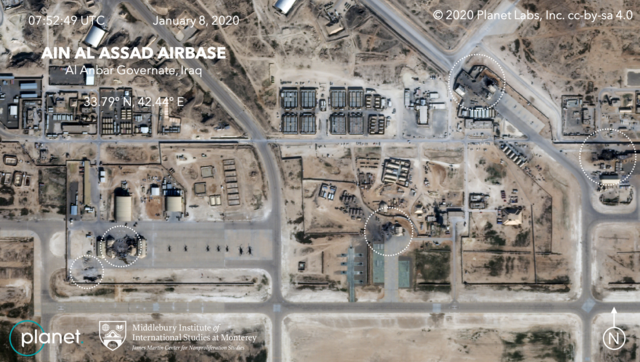
| תיאור | Satellite image, showing the damage to at least five structures at Ain al-Assad air base in Iraq in a series of precision missile strikes launched by Iran |
| תאריך יצירה | |
| מקור |
First upload: Brumfiel, Geoff; Welna, David (8 January 2020). Satellite Photos Reveal Extent Of Damage From Iranian Strike On Air Base In Iraq. NPR. Current upload: Garger, Kenneth (8 January 2020). Before-and-after satellite images show damage to Iraqi base hit by Iran. New York Post. |
| יוצר | Planet Labs, Inc. / Middlebury Institute of International Studies at Monterey |
| אישורים והיתרים (שימוש חוזר בקובץ זה) |
There is a copyright notice in the upper right of this image. "© 2020 Planet Labs, Inc. cc-by-sa 4.0" |
רישיון
הקובץ הזה מתפרסם לפי תנאי רישיון קריאייטיב קומונז ייחוס-שיתוף זהה 4.0 בין־לאומי.
ייחוס: Planet Labs, Inc.
- הנכם רשאים:
- לשתף – להעתיק, להפיץ ולהעביר את העבודה
- לערבב בין עבודות – להתאים את העבודה
- תחת התנאים הבאים:
- ייחוס – יש לתת ייחוס הולם, לתת קישור לרישיון, ולציין אם נעשו שינויים. אפשר לעשות את זה בכל צורה סבירה, אבל לא בשום צורה שמשתמע ממנה שמעניק הרישיון תומך בך או בשימוש שלך.
- שיתוף זהה – אם תיצרו רמיקס, תשנו, או תבנו על החומר, חובה עליכם להפיץ את התרומות שלך לפי תנאי רישיון זהה או תואם למקור.
היסטוריית הקובץ
ניתן ללחוץ על תאריך/שעה כדי לראות את הקובץ כפי שנראה באותו זמן.
| תאריך/שעה | תמונה ממוזערת | ממדים | משתמש | הערה | |
|---|---|---|---|---|---|
| נוכחית | 09:14, 9 בינואר 2020 | | 1,132 × 2,000 (4.5 מ"ב) | EnchanterTim | Higher resolution from: https://nypost.com/2020/01/08/before-and-after-satellite-images-show-damage-to-iraqi-base-hit-by-iran/ |
| 22:52, 8 בינואר 2020 |  | 449 × 800 (805 ק"ב) | Cold Season | {{Information |Description= Satellite image, showing the damage to at least five hangars and buildings at Ain al-Assad air base in Iraq in a series of precision missile strikes launched by Iran |Source= [https://www.npr.org/2020/01/08/794517031/satellite-photos-reveal-extent-of-damage-at-al-assad-air-base?t=1578512699906 Satellite Photos Reveal Extent Of Damage From Iranian Strike On Air Base In Iraq]. NPR. |Date= 8 January 2020 |Author= Planet Labs Inc./Middlebury Institute |Permission= |ot... |
שימוש בקובץ
הדף הבא משתמש בקובץ הזה:
שימוש גלובלי בקובץ
אתרי הוויקי השונים הבאים משתמשים בקובץ זה:
- שימוש באתר ar.wikipedia.org
- שימוש באתר be.wikipedia.org
- שימוש באתר ca.wikipedia.org
- שימוש באתר ckb.wikipedia.org
- שימוש באתר en.wikipedia.org
- שימוש באתר es.wikipedia.org
- שימוש באתר fa.wikipedia.org
- שימוש באתר fi.wikipedia.org
- שימוש באתר fr.wikipedia.org
- שימוש באתר id.wikipedia.org
- שימוש באתר ja.wikipedia.org
- שימוש באתר ka.wikipedia.org
- שימוש באתר ko.wikipedia.org
- שימוש באתר nl.wikipedia.org
- שימוש באתר nl.wikinews.org
- שימוש באתר pnb.wikipedia.org
- שימוש באתר pt.wikipedia.org
- שימוש באתר ru.wikipedia.org
- שימוש באתר ru.wikinews.org
- שימוש באתר so.wikipedia.org
- שימוש באתר uk.wikipedia.org
- שימוש באתר ur.wikipedia.org
- שימוש באתר vi.wikipedia.org
- שימוש באתר www.wikidata.org
- שימוש באתר zh.wikipedia.org